Wednesday, December 31, 2008

Map of the Week - Stay Indoors!

I'm not a regular at NOAA's weather pages so I don't know how typical this is but today's weather map sure looks scary-and colorful too! The legend was hard to copy and paste and is hard to read anyway. You can click the image to get to their interactive map and see what you should be scared of in your back yard. We've got advisories on boats, wind, avalanches, floods, fire, gales, snow storms (I'm watching one as I type), cold and fog. Even Hawaii's in on the action with surf advisories. The ten plagues! One of the safest places to be today is Alaska.
Have a great New Year, stay warm and dry!

Wednesday, December 24, 2008

Map of the Week-Christmas Lights

With all the do it yourself map technology available it's surprising how few maps of Christmas lights I've been able to find. The best one for sheer volume is the Chicagoland Christmas Lights page.

The locations are color coded and you can click them for more information. Unfortunately no pictures come up but some of them have web links such as Nick's Lights. Thank you Nick Diaz. Happy holidays!

Wednesday, December 17, 2008

Map of the Week-Are You Happy?

This map shows "subjective well being" and is based on data from Eric Weiner's The Geography of Bliss. So maybe you thought Disney World was the happiest place on earth but you're wrong! It's Denmark!

I have not read this book so I don't know what all the criteria are but the caption references Happy Denmark's free education and health care as well as spending on the elderly and children. I agree that governments should spend on the elderly and children but am a bit skeptical that spending = happiness.


The map was produced by a geography student at
the University of Oregon and appeared in their alumni magazine. Thanks to Michael5000 for another great submission. Yes it only takes me 5-6 months to get reader's submissions out!

Tuesday, December 16, 2008

Map Of Maryland Counties

Maryland is a state in the United States, located in the Mid Atlantic region. It
borders Pennsylvania to the north, Delaware to the east, and Virginia, West Virginia, and the District of Columbia to the south and west.

It is a small state, only 101 miles (145 kilometers) wide, and 249 miles (400 km) long, ranked 42nd in the US for geographical size. In population it is ranked 19th in the US, with a total population of 5,618,344. Interestingly, it has the highest median income of any US state.

The largest city is Baltimore, with a population of 637,455, and a metropolitan area of 2.6 million. It is also part of the extended conurbation called the Baltimore-Washington Metropolitan Area of around 8.1 million people.


Here are some map of Maryland counties for free.

Free map of Maryland Counties.


Maryland county map for free printout.


Map of Maryland counties for free download.


Another map of Maryland's counties for print or download.


Here is a free detailed map of State of Maryland for download.


Free map of state of Maryland for travellers.


I hope you found a map of Maryland counties that's suitable for your purposes. Thanks for visiting. Be sure to bookmark/subsribe/follow this blog so you can find new map collections any time.

Printable Maps North Carolina

The US state of North Carolina is located on the Atlantic coast in the southeastern United States. To the south lie South Carolina and Georgia, to the west lies Tennessee, and to the north lies Virginia.

The capital city of North Carolina is Raleigh with a population of 380,173. The largest city is Charlotte with a population of 671,588, with a extended metropolitan area housing 2,491,650 residents.

Below are a number of Printable maps North Carolina for free.


Here you can download one of the best North Carolina atlas maps I've been able to track down.

Detailed North Carolina Atlas Maps for free.


Here you can find a detailed street map of North Carolina.

Detailed street map of North Carolina.


Here's another free road map of North Carolina in detail showing major highways and freeways.

Free detailed road maps of North Carolina.


Here's a map of cities in North Carolina, the major cities that are county seats.

Maps of cities in North Carolina along with counties.


I hope these printable maps North Carolina downloads were useful. Happy travels down south!

Thursday, December 11, 2008

Map of the Week-Filling Empty Space

King Abdullah University of Science and Technology (KAUST) is being built on an empty desert landscape around the village of Thuwal, Saudi Arabia. They have put together this interactive map (takes a minute or two to load) as a recruiting tool. In their own words:
"Just launched this month, the map offers students, faculty, research partners and community members the opportunity to explore the university via an immersive and cutting edge digital map, highlighting everything from residential flats, lab and research facilities, sustainability features, community services, recreational facilities, flyover video and more.
Currently the interactive map's main purpose is that of a recruiting tool, something which differentiates it from virtually every other campus map. Rather than showing students how to get from point A to point B, however, the map serves to share the KAUST story with them. Also, KAUST is using the map to showcase its commitment to sustainability by highlighting the green aspects of every building."

The map allows you to switch between the plans for the university and an aerial view (left) and is "the only physical link to an entire institution which does not yet exist."


This empty piece of desert is rapidly being transformed as this recent photo shows.

Soon it will look like this:

Thanks to Jason Hellman of Fleishman-Hillard for the above comments.

Thursday, December 4, 2008

The Daily Masshole Obstacle Course

I frequently complain about my commute. Yes it's "only" 8 miles but 8 miles of stress. It is much more stressful than my job and probably the main thing that leaves me drained at night. In addition to the usual problems of heavy traffic, construction, bad roads and "Masshole" drivers, the route itself is a crazy serpentine pattern-there is no straight line to get me there.
Below is a map of my route through eastern Massachusetts. I've generalized it a bit and left off place names to make it less obvious where I live and work. Green text indicates southbound issues, purple northbound and black means the problem is in both directions.

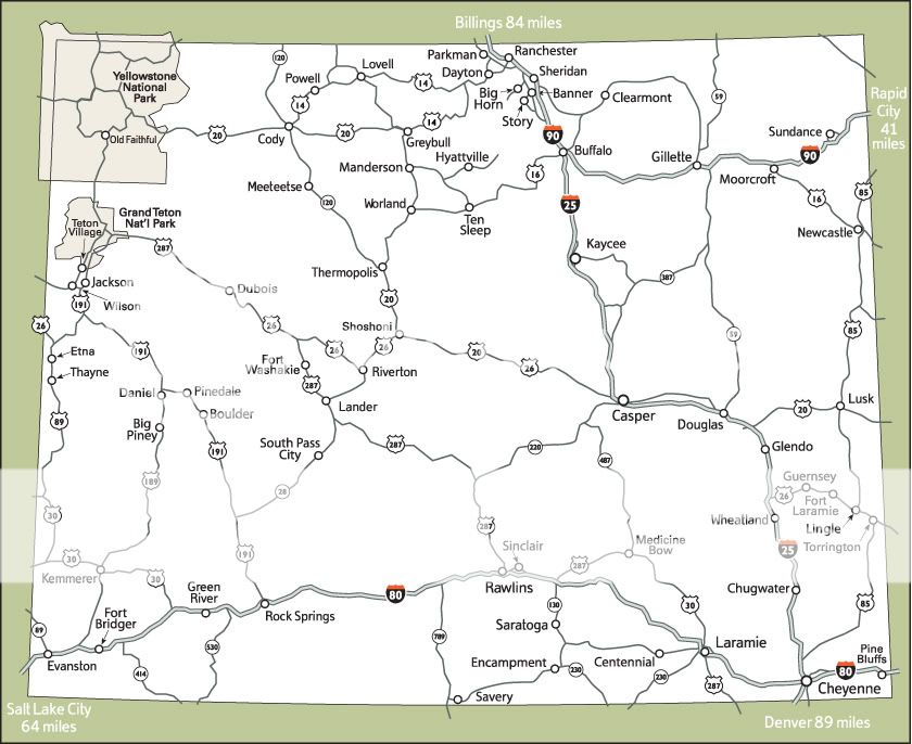
The 8 mile route takes me 25 minutes with no traffic, 35-40 minutes typically and can be up to an hour in bad traffic situations. I can ride my bicycle there in 40-45 minutes when I don't get whacked. Public transit is a 3 bus system and takes an hour and 20 minutes. Walking? I haven't tried that one yet.

Sunday, November 23, 2008

Map Of The State Delaware

You have found the right page if you are looking for a map of the state Delaware.

Delware is a state on the east cost of the USA, bordering Pennsylvania, Maryland, and New Jersey. It is the second smallest state after Rhode Island, with a total area of 2,490 square miles (6,452 km²). It does, however, have the sixth highest population density with a population of 864,764, or 442.6 per square mile (170.87 per km²).

Delaware is divided into three counties: Sussex, Kent, and New Castle, with 60% of the population living in New Castle. The capital city is Dover, with a population of 35,811. The largest city is Wilmington, with a population of 72,826.

Here is one detailed Delaware map showing highways and roads.
Free detailed Delaware Map for visitors and commuters.

Here is another map of the state of Delaware, showing roads, counties, and cities.
Good map of the state of Delaware for free.


Here is a physical map of Delaware showing topography.
Free simple physical map of Delaware.


Were you able to find a good map of the state Delaware up above? Thanks for having a look at these maps. Be sure to bookmark or subscribe to the feed so you can check out more printable map collections in the future. See you next time!

Thursday, November 20, 2008

Map of the Week-Cotton Pickin' Democrats!

Yes these images have made the rounds of many other map blogs and yes I was supposedly done with Election 2008 but this is interesting. In my November 5th post I alluded to the county patterns and the possible race factor among others. Now we have courtesy of Allen Gathman from Southeast Missouri State University (Go Redhawks!) an explanation. He compared an 1860 map of cotton production to the pattern of southern counties that voted for Obama on this page. The Strangemaps blog took this a step further and actually overlaid the two maps. Each dot from the 1860 map represents 2000 bales of cotton.


There is the obvious racial component as the cotton belt counties have a higher concentration of African Americans. However, the Vigorous North blog takes this even another step beyond to show how the shallow ocean waters of the Cretaceous Period influenced the soil types and thus the suitability for cotton and thus the racial settlement patterns and thus the election results in the cotton belt counties.

The Map Of Minnesota State

Minnesota is a state in the Midwestern area of the United States of America. It is the northermost state in the continental US (ie. excluding Alaska which is further north of course), lying on the shores of Lake Superior and bordering Canada to the north. It is bordered to the west by North Dakota and South Dakota, Iowa to the south, Wisconsin to the east, and also shares a water border with Michigan.

It is the twefth largest US state by size, having a total area of 87,014 square miles
(225,365 km²). It is the 21st most populous state, with a population of 5,197,621. Almost 60% of those people live in the Minneapolis-Saint Paul metropolitan area (aka The Twin Cities).

Below you can find various versions of the map of Minnesota state.


This is one of the best road maps for Minnesota state that I've found.

Printable road maps for minnesota commuters.


Here's another small Minnesota highway maps for print.

Detailed Minnesota highway maps to print.


This is Superior National Forest Map Minnesota.


Superior National Forest map Minnesota.


This is the map of Minnesota state that I used to prepare for my business trip to a conference there.


Here is the map of Minnesota state for print or download.


I hope you found the maps of Minnesota above to be useful for reference and as a travel companion. Next time you go on a trip make sure to sure the map collections here! See you next time!

Wednesday, November 19, 2008

Printable State Of Ohio Map

If you are looking for a printable state of Ohio map, you've come to the right place! Ohio is a state in the Midwestern region of the United States of America. "Ohio" also means "Good morning" Japanese (as if you care!).

It is the 34th largest state in the USA, with a total area of 44,825 square miles
(116,096 km²). It borders Michigan to the north, Indiana to the west, Kentucky to the south, West Virgina to the southeast, and Pennsylvania to the northeast.

It is the 7th most populous state in the USA, with an estimated population of 11,466,917. Its largest city and captial is Columbus, with a population of 747,755 and a metropolitan area of 1,754,337. The metropolitan areas of Cincinatti and Cleveland are actually larger, despite the cities themselves having smaller populations than Columbus. Greater Cincinatti has a population of 2,133,678, BUT the urban is located not only in Ohio but also stretches across the borders into Indiana and Kentucky. The largest metropolitan area located completely in Ohio is Greater Cleveland with a population of 2,096,471.

Note that some of these map files are larger than they appear once you download them (I squeezed them into the small space here but the source file is full size).


Here is a good map of Ohio cities and towns.

Free detailed map of Ohio cities and towns.


Here is a detailed map of Ohio with roads and highways.Large detailed map of Ohio state for with roads and highways.


Here is a simple and printable state of Ohio map to download.

Simple printable state of Ohio map file.


Here is another Ohio map including counties and the capital city.
Ohio map including counties and their borders.


I hope you found the above printable state of Ohio map images useful. Make sure to print them and bring them along on your visit to Ohio. Don't forget to bookmark or subscribe before you go. Have a great trip!

Tuesday, November 18, 2008

Online Maps North Dakota

North Dakota is a state in the Midwestern United States. It is bordered to the south by South Dakota, to the west by Montana, to the east by Minnesota, and to the north by the Canadian provinces of Saskatchewan and Manitoba.

It is the 48th most populous state, with a small population of only 640,000. But it is the 19th largest state by size, with an area of 70,762 square miles (183,272 km²).

The largest city in North Dakota is Fargo, with a population of around 100,000, and a metropolitan population of 192,417. The capital is Bismarck, with a population of 55,532.

Here you can find some online maps North Dakota for free download or printout.

First is a North Dakota County map.

Free North Dakota Country Map downloads.


Next is a Geographical map North Dakota.Geographical Map North Dakota.


Here is a North Dakota road map.
Online Maps North Dakota.


I hope the above North Dakota county map and geographical map North Dakota printables were useful. Don't forget to check out our other map collections before you go! And for future reference be sure to subscribe or bookmark. See you next time!

Thursday, November 13, 2008

Map of the Week-Strolling Baby Through Weird Alternate Realities


Here's a delightfully odd marketing strategy. Bugaboo strollers (right) has enlisted some avant-garde artists to make a series of day trip maps for cities in Europe, North America and Australia. They have points of interest you can click on to get more info. Apparently "third world" places such as Asia, Africa and Philadelphia don't rate with them.

One of the more interesting ones is Mina Monnee's Portland. I especially like how she wrapped the river around it.


I also like Prague by Dustin Arnold.

Robert Nakata has some of the most "artistic". Here are his renderings of Toronto and Brighton (England)

State Of Arkansas Map

Arkansas is a state in the southern USA. It is bordered by Louisiana to the south, Texas to the southwest, Oklahoma to the west, Missouri to the north, and Tennessee and Mississippi to the east.

The population of Arkansas is 2,834,797, making it the 32nd most populous US state. The capital and largest city is Little Rock, with a population of 187,452, and a metropolitan population of 666,401.

The total area of the state is 116.8 square miles (302.5 km²). The Arkansas River runs through the state, and Little Rock is located on the edge of the river.

Here is a detailed map of Arkansas. This is the thumbnail, but you can see the full map by clicking the thumbnail.

Thumbnail of detailed map of Arkansas.

Here is another few state of Arkansas map files to print or download. I hope you found them useful.State map of Arkansas counties.


Printable state of Arkansas map for travelers.


State of Arkansas map for visitors to the USA.


The state of Arkansas is a lovely place to visit, and I hope the above maps were helpful in planning your trip. Enjoy your stay in Arkansas!

Tuesday, November 11, 2008

Map Of Cities Counties In Oklahoma

Oklahoma is state in the southcentral area of the United States of America. It has a population of 3,617,316, making it the 28th most populous state. The largest city and capital is Oklahoma City, with 537,734 residents. The metroplitan area has approximately 1,192,989.

Oklahoma's total land area is 69,898 square miles (181,196 km²), making it the 20th largest state. Oklahoma is located north of Texas, west of Arkansas, south of Kansas, southwest of Missouri, and southeast of Colorado.

Below you will find a map of cities counties in Oklahoma state. Please download as print these out as you wish.


Grey map of cities counties in Oklahoma for travelers.


Road map of cities counties in Oklahoma.


Multicolored map of cities counties in Oklahoma state for out of state travelers.


Black and white map of cities and counties in Oklahoma for visiting tourists to print and carry.


I hope you found useful state map of cities and counties in Oklahoma. Be sure to subscribe or bookmark before you go.

Monday, November 10, 2008

Printable Map Of Wyoming

Wyoming is a state in the Western United States, which lies in the area of the Rocky Mountains, with the eastern section of the state lying in the High Plains area. It is the least populous state in the union, with only 522,830 people. It is, however, the tenth largest state by size. Its total land area is 97,818 square miles(253,348 km²).

The capital and largest city in Wyoming is Cheyenne, with a populous of 53,011. Don't feel bad if you've never heard of it. Most people haven't.

Wyoming lies south of Montana, west of South Dakota and Nebraska, north of Colorado, northeast of Utah, and east of Idaho.

For those of you planning on trekking out into this sparsely populated area, here you can find a printable map of Wyoming for reference during your travels.


Printable Maps Of Wyoming for travelers.


Wyoming map printable for reference.


Physical printable Maps of Wyoming for visitors.


Printable map of Wyoming state and its regions and counties.


It's my hope that you found a printable map of Wyoming up above that was helpful to you. Be sure to check out some other map themes and destination profiles before you go. See you later!