Friday, September 26, 2008

Map of the Week-The World According to UAlbany

I just got my alumni magazine from UAlbany aka SUNY Albany, Albany State, University at Albany (my school changes its name every other year). The cover has this world map, strangely reminiscent of the childrens' maps I showed a few weeks ago from the Barbara Petchenik Competition. Yes we're proud of our worldly outreach - we even found the other two places that are not NYC (Boston and Canada) and proudly label them on our map.
There's also a big suspension bridge linking the Rocky Mountains with the Pacific Ocean and a 150 mile tall palm tree growing in central Florida. We also moved Mount Fuji to Mongolia for your convenience!

Thursday, September 25, 2008

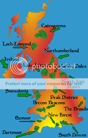
Map Of National Parks UK

Map of national parks UK, Cairngorms, Scotland.

There are 13 national parks throughout Great Britain, including 8 parks in England, 3 parks in Wales, and 2 parks in Scotland. In England, those 8 national parks occupy 7% of the total land area. Scotland's 2 national parks cover 7.3% of the total land area. And Wales' 3 national parks occupy 20% of the total land area!

The largest of the UK's national parks is Cairngorms National Park in Scotland, totalling 1467 square miles (2361 square km).

Below you can see a map of national parks UK. I hope you find map that is helpful and useful to you!

Map Of National Parks UK showing protected areas in green.


Map of national parks UK and their proximity to major cities.


Map of national parks UK showing the names of the parks.


Thank you for seeing these map of national parks UK informations. Please check again for new updates and map collections! See you next time!

UK Map Showing Counties

UK map showing counties in constituent countries.


The United Kingdom consists of 4 constituent countries, which are not independent countries, but "countries-within-a-country", autonomous entities that share citizenship, a national parliament, and defense forces. Culturally they are often considered separate nations, for example in European sports leagues. British pounds are the currency used in the constituent countries, though each countries has its own coins and bills with their own countries' symbols and cultural heritage reflected.

Each UK constituent country is divided into counties (though sometimes not referred to as counties, they function at the county level). There are 82 counties in England. Scotland has 33 counties. The country of Wales has 23 counties. And Northern Ireland has just 6.

Here you can find and print out a UK map showing counties in each of the constituent countries of England, Scotland, Wales, and Northern Ireland. Some maps also show Ireland (not a part of the UK).


UK Map Showing counties in England, Wales, Scotland, and Northern Ireland (Ireland as well).


Map of UK Counties in England, Scotland, and Wales. Blank counties map with no labelling.


UK Map Showing Counties in England and Wales.


This Map of UK counties also shows Ireland.

Map of UK Counties in Great Britain, Northern Ireland, and in addition Ireland (which is not in the UK).


I hope that up above you could find a UK map showing counties that was useful for you. Be sure to check back again soon for more map collections. See you next time!

Wednesday, September 24, 2008

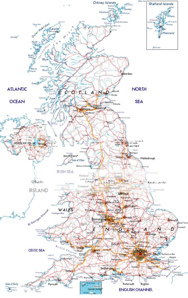
Detailed Street Map Of UK

Detailed Street map of UK. Here's an English country road in all its brilliance.

The United Kingdom of Great Britain and Northern Ireland, often referred to as the UK OR just Britain, consists of the four countries of England, Scotland, Wales, and Northern Ireland in a single union.

Here's a detailed street map of UK country to aid you in your travels there.


Detailed Street Map Of UK from Scotland to Northern Ireland.


I hope the above map was useful. If you want a more specific area to look at, you can find plenty more free road maps of UK regions online.

I will be searching for more detailed street map of UK, and when I find more I will add them. Check back again soon!

Sunday, September 21, 2008

France Geographic Map

Physical maps of France with its beautiful scenery.France is country located in Western Europe, but also maintaining some overseas territories and islands and islands. Mainland France extends from the English Channel and North Sea in the north to the Mediterranean in the south, and from the Rhine Valley to the Atlantic Ocean. France has a total land area of 674,843 km², making it the 40th largest country in the world.

France borders Belgium, Luxembourg, Germany, Switzerland, Italy, Monaco, Andorra, and Spain in Europe. The French overseas department of Saint Martin borders the Netherlands Antilles, and the French overseas department of French Guiana borders Brazil and Suriname.


Here you can find a France geographic map for further information and detail.

France geographic map from atlas scan.

Detailed France geographc map showing elevations.

High quality France geographic map with great fine detail.

United Nations-produced France Geogaphic Map.

This map shows the French overseas department of Saint Martin, which borders the Dutch territory of Sint Maarten (part of the Dutch Antilles).

France geographic map of overseas department Saint Martin.

This physical map shows the French overseas department of French Guiana, located in South America.

French Guiana overseas department geographic physical map.

I hope you found a useful France geographic map to download. Be sure to check back for future map collections of France, Europe, and the whole world. See you again next time!

Printable Maps Of California

Maps of San Diego California that are printable.California is a state in the United States, located on the Pacific coast. It is bordered by the state of Oregon to the north, Nevada to the east, Arizona to the southeast, and Mexico to the south. It is the third largest state with a total land area of 163,696 sq miles (423,970 km²). It's largest cities are Los Angeles, San Diego, San Jose, and San Francisco. It is the most populous US state, with a population of 36,553,215 (more than all of Canada!).

California was originally colonized by the Spanish in the 18th century, later to become part of Mexico. But California was lost to the United States in the Mexican-American War of 1846-1848.

Here are some printable maps of California that you may find useful for your school project, etc.


Printable maps of California showing major cities and towns on gray background.

Outline printable maps of California showing counties.

Printable maps of California showing the main towns and main highways.

Blank outline printable map of california for school tests.

Thanks for giving these printable maps of California a look! Be sure to check back for more map collections in the near future!

Saturday, September 20, 2008

Location Map Anaheim California

Location of Anaheim California map photo.Anaheim, California is located in Orange County, in the Greater Los Angeles area. Known worldwide as the home of Disneyland, Anaheim itself is a fairly major city boasting a population of 346,823 people, making it the 10th most populous city in California. Though part of the suburban sprawl of Los Angeles, it is located about 40 miles (65 km) away from Los Angeles, and is about an hour's drive. Indeed, L.A.'s urban and suburban sprawl is massive.

Anaheim has designated a commercial district of the city as "Anaheim Resort", including Disneyland, related shops and hotels in the area, the Anaheim Convention Center, Honda Center (home of the Anaheim Mighty Ducks), and Angel Stadium (home of the Los Angeles Angels of Anaheim). The city has undergone huge changes to attract tourists to Anaheim resort.

Here you can download a location map Anaheim California. I hope they're useful.

Location Map Anaheim California and Disneyland.

Location map Anaheim California and surrounding area in Orange County.

Location map of Anaheim in California, Orange county, near Los Angeles.

Location map of Anaheim California.

Location map: Anaheim California and Long Beach.

I hope you found a useful and informative location map. Anaheim California is a lovely town to visit and a source of pride for its residents.

Map Of Major Earthquakes In California

The Loma Pietra major Earthquake in San Francisco, California.The US state of California is extremely earthquake-prone due to its location on San Andreas fault line. This fault line forms the tectonic boundary between The Pacific plate and the North American plate. The land of the Pacific plate is moving to the northwest, while the land of the North American plate is moving to the southwest. The rate of movement is about 33-37 milimeters per year. The compression of this motion causes California's earthquakes.

California has frequent earthquakes of magnitude 6 or greater, and those of magnitude 7 or greater typically occur in every decade. Luckily most of these are not located near major population centers.

One of the most recent earthquakes to heavily affect a major population center was the Loma Prieta earthquake of 1989, which caused heavy damage, 63 deaths, and 3757 injuries, and left thousands more homeless.

Here you can choose a map of major earthquakes in California for further information and detail.


Map of major earthquakes in California showing 3 big ones.

Map of Major California earthquake history.

Map of major earthquakes in California with historical magnitude.

Detailed map of major earthquakes in California history. This is specificall Southern California.

Map of major earthquakes in California from 1769 to 2000. Magnitude range is displayed.

I hope you found the above map of major earthquakes in California useful and informative. Be sure to bookmark or subscribe because I add new map collections every day. See you soon!

Friday, September 19, 2008

Map Of 21 Missions Of California

21 Spanish Missions dot the California coast.The missions of California were Spanish settlements initiated by Spanish King Charles III and built between between 1769 and 1823. The Spanish had already claimed this land over 200 years earlier, but didn't start settling it until they heard of plans by other powers to settle the area. The missions were a way of laying claim to the area.

Missions were chosen as the first settlements as a way of creating a unified system of commerce for the whole area in advance of the founding of towns and cities. The Spanish decided to create farms, each located 1 day's journey away from the next. This would ensure a contiguous trade route along the coast (they were built near the coast to have easy access to future sea ports). But there were not yet any Spanish settlers in the area, so who would farm the lands? Newly converted Native Americas would farm the lands! That's why missions were chosen--to create an obedient labour force while fulfilling the Catholic mission of conversion at the same time (though I suspect the former was a more important factor!).

The missions were disastrous for the local natives, but helped shaped California into the state it is today.

Here are some map of 21 missions of California. I hope they're useful and informative!

Map of 21 Missions of California showing exact location.

21 missions map of California coast.

Map of 21 missions of California with their precise location.

21 missions map of California El Camino Real.

I hope you found these 21 missions map of california useful! Be sure to check back again for future map collections.

Thursday, September 18, 2008

Map: Counties California

The state of California in the USA has 58 counties. Every part of California belongs to one of the 58 counties, and the county is the default local government authority. So if you are outside of any city or town, you are in the county's jurisdiction.

As one would expect, the most populous county is Los Angeles county, with 9,519,338. The least populated county is Alpine County, with a population of 1,208! It is located on the border of The State of Nevada.


Here you can download a good Cali map. Counties California maps for download.

Printable map counties California locations.

Colored map counties California for SoCal travel.

Blue map of California counties.

Map: Counties of California with a closeup of central region.

Here's a Southern Califoria counties map or two for more specific info.

Southern California Counties Map.

Southern California counties map of Socal physical map.

Detailed Road Map Of California

Photo of a California road.The state of California occupies 160,000 square miles (414,000 km2) of land, making it the third largest state in the USA after Alaska and Texas. The state is 770 miles (1,240 km) long from north to south, and 250 miles (400 km) wide.

California is connected by an extensive and excellent system of state highways. Below you can find a detailed road map of California for your convenience and information.

Detailed road map of California and Nevada states.

Detailed road map of California.

I hope you found the above detailed road map of California useful! Be sure to check back often for more map collections of destinations in the USA and around the world.