Tuesday, November 24, 2009

Map of the Week- Lookout Mountain

On this day in 1863 Union and Confederate forces fought the Battle of Lookout Mountain. After losing a major battle at Chickamauga in September, Union forces gained control of this strategic overlook and the following day forced the Confederate troops off nearby Missionary Ridge. These battles enabled the Union Army to control most of Tennessee and set the stage for later campaigns in Georgia.


This battle and many others are nicely documented in maps for Wikipedia by amateur Civil War historian Hal Jesperson.


He also sells coffee mugs and t-shirts featuring his maps at Zazzle. Maybe someday he'll make a Lookout Mountain coffee mug that looks as nice as this one showing the Battle of Shiloh.

Sunday, November 22, 2009

Map of Isreal

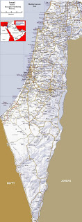
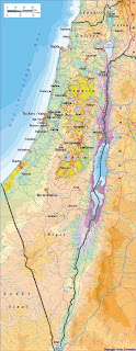
If you are looking for a map of Isreal you can find some below. Israel is a small country in the Middle East, that was created from the British Mandate territory called Palestine. Isreal was created as a Jewish state, and the Westbank became administered by Jordan, and the Gaza Strip became administerd by Egypt. Jordan and Egypt's territories are now under partial Israeli occupation and partial Palestinian self rule.

Isreal (minus Gaza and the Westbank) has a total population of 7,465,000. The population is 75.4% Jewish, 20% Arab, and 4% other minorities including Russian immigrants of partial Jewish ancestry. The total land area of Isreal (minus all disputed territories) is only 20,770 square km. For comparison, that is about 2/3 the size of Vancouver Island. That makes Israel the 34th most densely populated country in the world with 356.8 people per square kilometer. This small size and high population density plays a roll in Isreal's territorial disputes with its neighbours.

Map of Isreal with disputed territories and surrounding countries
Map of Isreal and surrounding region
Political map of Israel with Westbank and Gaza, Golan Heights, and southern Lebanon

This road map of Israel shows lots of detail, but be careful because it does not show the borders of the Westbank and Gaza. In Israel those boundaries are not allowed to be printed on maps.

This map of Israel shows lots of detail

This map of Isreal shows the Palestinian autonomous areas. In yellow are areas theoretically under full Palestinian control. Nearby there are blue-green areas that represent Palestinian civil control and joint Israeli-Palestinian control of security. The other areas in between remain under full Israeli control. This map may be a little bit out of date because those areas continue to slowly change as Palestinians are given control over more land.

Map of Israel and the Palestinian territories

I hope you find the above maps of Israel and their explanations informative. Israel is a fascinating place where history is being made on a daily basis. I highly recommend you visit so you can see the situation firsthand.

Friday, November 20, 2009

Dead Sea Map

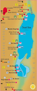
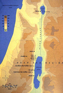
If you are looking for a Dead Sea map you can find one down below. I have visited the Dead Sea several times and its a fascinating otherworldly place. It really does look like something out of a science fiction film, especially the southern end of the lake which looks like the landscape of another planet.

The Dead Sea is a lake in the Middle East, bordered to the east by Jordan, and bordered to the west by the Westbank on its nothern end, and Israel on its southern end. The Dead Sea is 67 kilometers long from top to bottom, and 18 km wide at its widest point. It is a highly saline lake, because there is no way for water to drain from it other than by evaporation that leaves behind the salt. This high saline quality of the water is what allows people to float and have a weightless experience in the Dead Sea's waters. It's a must-do experience for all travelers.

Here are the Dead Sea maps below.

Dead Sea Map including surrounding areas like Judaen Hills

Closeup Dead Sea map in the Westbank and Israel
Dead Sea map of the Holy Land and Jordan

I hope the above Dead Sea map collection was useful. And I hope you somebody visit the Holy Land and take a dip in the real Dead Sea.

Wednesday, November 18, 2009

Map of the Week- Russia's Time Zones

President Dmitry Medvedev of Russia, in a recent speech, suggested reducing the number of time zones in Russia. A recent BBC article titled "Changing Times in Russia" highlights the difficulties of governing a country that has 11 time zones.


Businesses along the Amur River, across from China have a very short time window in which to be in contact with Moscow during normal working hours. Much of that region's economy has stronger economic ties to China, being closer not only geographically but temporally. The region could possibly improve ties to western Russia and Europe by changing their clocks to be in a closer time zone. 

China, despite spanning five time zones has adopted one time zone for the entire country. Taiwan, Hong Kong and Macau also use this same time zone. Russia is much too big and would more likely combine several of the time zones on the map above. The BBC article did not list any specifics from Medvedev 's speech but according to Georgian Daily he has proposed cutting the number of time zones to four.

Russia's 11 time zones are a source of pride for many, showing how large the country is and resistance to the plan is expected. A quote from a skeptical scholar of the plan via the Georgian Daily article:
Moscow can cut the number of time zones but it can’t change the shape of the earth or the speed of its rotation relative to the sun.
At least we hope they can't. They do have nukes!
Here is a list of the time zones:

Kalningrad:   UTC (aka GMT) + 2
Moscow:   UTC + 3
Samara:   UTC + 4
Yekaterinburg:   UTC + 5
Omsk:   UTC + 6
Krasnoyarsk:   UTC +7
Irkutsk:   UTC +8 - this is China's time zone
Yakutsk:   UTC +9
Vladivostok:   UTC +10
Magadan:   UTC +11
Kamchatka:   UTC + 12

Map of Korea

Korea is a country that is now divided into two, the communist North Korea and the democratic South Korea. The area of the entire country if reunified is 223,170 square km. And the entire population would be 72,285,392.

South Korea by itself has a total land area of 100,140 square km. Its population is estimated at 48,379,392. North Korea by itself has a total land area of 120,540 square km. Its population is estimated at 23,906,000.

Below you can find a map of Korea for further reference.

Map of Korea, physical geographic
Map of Korea, South
Geographic Physical map of Korea, both North and South
Simple map of Korea, both North and South

If you're heading over to Korea I hope you enjoy your stay. I assume you'll be visiting South Korea. It's a fascinating and exciting country in transition into a fully developed economy, so now is a great time to visit.

Monday, November 16, 2009

Central America Map

Despite common misconception, Central America is not a continent. It is a region of the North American continent, specifically the southernmost portion that borders South America. It is an isthmus, which is a narrow strip of land that bridges or connects two large land masses.

There are seven countries in Central America, specifically Belize, Costa Rica, El Salvador, Guatemala, Honduras, Nicaragua, and Panama. The primary language of these countries is Spanish, but many other indigenous languages are spoken.

The region has a total land area of 523,780 square km, and a total population of 47,739,000. This gives it a fairly high population density of 77 people per square km.

Below you can refer to a Central America map for further information.

Useful Central America map
Central America map images for reference
Central America maps for visitors
Colored Central America map of the region

I hope the above Central America maps are useful to you and I hope you enjoy your time in Central America if you visit!

Thursday, November 12, 2009

Map of the Week- Where was the Wall?

There's been much media coverage of the 20th anniversary of the fall of the Berlin Wall. One story I heard was about how some residents of Berlin no longer remember exactly where the wall was located. The German Senate has been working to preserve remnants of the wall and border fortifications. Berlin's official web site has a nice online map and guide showing the course of the wall and the associated monuments. This overview map allows the user to add artistic, memorial and historic sites and click on them for details.


 Below is a zoomed in view of the area around the Pariser Platz and Brandenburg Gate.


The web site also has aerial views, history, photos and tourist information.

There is also a 3D view although it requires the Google Earth plugin and does not allow for much interaction.


Here is an aerial view of the Checkpoint Charlie area combined with a map of that location.


The City has also constructed a hiking and bicycling trail along the 160 kilometers of the former border, most of it following the border control roads used by the two governments. The website has a nice description of each section of the trail and also has a link to the Mauer Guide, a downloadable GPS tour that traces the path of the wall with historical information. The guide can be loaded to a cell phone or other handheld device.

Happy 20 jahre mauerfall!

Wednesday, November 4, 2009

The Map as Art-Exhibit Opens Tomorrow

The Map as Art opens tomorrow at the Christopher Henry Gallery in New York City. This is a group show curated by Christopher Henry and Katharine Harmon, author of the really great map book "You Are Here: Personal Geographies and Other Maps of the Imagination." The show shares its name and accompanies the launch of Harmon's new book. There is an opening reception tomorrow (November 5th) from 6-9 PM.

The gallery is "conveniently located off the Elizabeth Street ramp of the Lower Manhattan Expressway" as illustrated below. Those of you in NYC might actually get the joke.


I did not get any images from the show other than what's on the gallery's site. Below is "Strike Anywhere" by Doug Beube.


Many artists are featured including Joyce Kozloff and Karey Kessler.

Here's a quote from the press release. I'm not sure how much I agree with it but it's an interesting take on mapping.

"In the guise of offering illumination, maps obscure. They purport to bring order to the fundamental chaos of life, promising clarity in the face of flux, and claiming knowledge of the unknowable. In their quest to demarcate our differences, they comfort us even as they give the lie to the notion of common experience."