The tall orange triangles on the map are "decade volcanoes." I've never heard that term either but according to the description page it means a volcano "currently noted to have a history of large eruptions and a proximity to populated areas." In other words if one of those blows it's really going to mess things up.
Wednesday, June 30, 2010
Map of the Week-GOOD Volcano Map
GOOD is an online journal that asks the question "what is good right now?" One of the highlights is their "transparency" series of graphics and maps. The latest transparency shows how small the recent Eyjafjallajökull volcanic eruption in Iceland was compared to other historic volcanoes. The disruption to the economy and to air traffic was huge but as the graphic indicates we should expect much worse in the future.

The tall orange triangles on the map are "decade volcanoes." I've never heard that term either but according to the description page it means a volcano "currently noted to have a history of large eruptions and a proximity to populated areas." In other words if one of those blows it's really going to mess things up.
The tall orange triangles on the map are "decade volcanoes." I've never heard that term either but according to the description page it means a volcano "currently noted to have a history of large eruptions and a proximity to populated areas." In other words if one of those blows it's really going to mess things up.
Monday, June 28, 2010
char minar hydrabad india history travel guide,
Charminar Travel Guide, History, Information

Charminar is famous place to visit in hydrabad, india. It meaning "Mosque of the Four Minarets" and "Four Towers" is the most famous mosque and monument in the city of Hyderabad, capital of the state of Andhra Pradesh, India.
History of Charminar
Sultan Muhammad Quli Qutub Shah, the 5th ruler of the Qutb Shahi dynasty built Charminar in 1591 shortly after he had shifted his capital from Golkonda to what is now known as Hyderabad.
He built this famous structure to commemorate the elimination of a plague epidemic from this city. He is said to have prayed for the end of a plague that was ravaging his city and vowed to build a masjid (Islamic mosque) at the very place where he was praying. In 1591 while laying the foundation of Charminar, Quli prayed: "Oh Allah, bestow unto this city peace and prosperity. Let millions of men of all castes, creeds and religions make it their abode, like fish in the water."
Today one can see the city as evidence of the prayer being answered. The Mosque became popularly known as Charminar because of its four (Persian/Hindi char = four) minarets (Minar (Arabic manara) = spire/tower).
This beautiful colossus in granite, lime, mortar and, some say, pulverised marble, was at one time the heart of the city. Initially the wonderful monument with its four arches was so proportionately planned that when the fort was opened one could catch a glimpse of the bustling Hyderabad city as these Charminar arches were facing the most active royal ancestral streets. There is also a legend of an underground tunnel connecting the palace at Golkonda to Charminar, possibly intended as an escape route for the Qutub Shahi rulers in case of a siege, though the exact location of the tunnel is unknown.
Thursday, June 24, 2010
Mahabaleshwar Holiday Packages, Vacations, Travel, Tourist Guide
Mahabaleshwar Tourist Guide

Mahabaleshwar comprises three villages: Malcolm Peth, Old "Kshetra" Mahabaleshwar and part of the Shindola village. Mahabaleshwar is located at 17°55′N 73°40′E / 17.92°N 73.67°E / 17.92; 73.67. It has an average elevation of 1,353 metres (4,439 ft).
Nearest Airport
- Pune - 120 km
- Mumbai - 290 km
Nearest Railway Stations
- Satara - 58 km
- Veer (Konkan Railway) - 70 Km
- Pune - 120 km
- Miraj railway junction - 169 km
- Sangli - 165 km
The Venna lake is one of the major tourist attractions of Mahabaleshwar. The lake is surrounded by trees on all sides. A late winter evening boat ride through the slight fog is well appreciated. Tourists can enjoy a boat ride over the lake or a horse ride next to the lake. A number of small eateries line the banks of the lake. The Mahabaleshwar city market and the S.T. bus stand is about 2KM from the lake and makes for a nice walk during the day. Most tour operators include the Venna lake in their tours. Most buses, private vehicles will stop at the Venna lake on their way to Mahabaleshwar on request.
Map of the Week-The $5.5 Million Fence
The G20 summit is coming to Toronto this weekend and you are NOT invited! They are building a security fence in your honor at an estimated cost of $5.5 Million according to the Globe and Mail. The fence is outlined in red on the map below. The lighter shaded area is where automobile traffic will be tightly controlled.

This area is right in the middle of downtown and encompasses many theaters, hotels, restaurants, sports venues and other attractions such as the CN Tower. Most of these places will be closed and the Toronto Blue Jays will be playing their "home" games this weekend in Philadelphia. That means the area's 25 or so baseball fans will miss Roy Halladay's big return to Toronto.
The Globe and Mail has an interactive map showing the security and closures. The items on the left side of the map can be clicked for locations and more information.

Also, if you are in or near the area be prepared to look good because you will be photographed as illustrated by this security camera map from the Toronto Star.


This area is right in the middle of downtown and encompasses many theaters, hotels, restaurants, sports venues and other attractions such as the CN Tower. Most of these places will be closed and the Toronto Blue Jays will be playing their "home" games this weekend in Philadelphia. That means the area's 25 or so baseball fans will miss Roy Halladay's big return to Toronto.
The Globe and Mail has an interactive map showing the security and closures. The items on the left side of the map can be clicked for locations and more information.
Also, if you are in or near the area be prepared to look good because you will be photographed as illustrated by this security camera map from the Toronto Star.
Map of the Week Bonus Coverage
A week ago the Los Angeles Lakers won another NBA title - zzzzzzzzzzzzzzzzzzzz. To honor the occasion here's a map cartoon from the New Yorker by Michael Crawford titled "Los Angeles Getting More Annoying as We Speak."

Shimla Tourist Places to Visit in India
Tara Devi: Just 11 km from the Shimla bus-stand. Tara Devi hill has a temple dedicated to the goddess of stars on top of the hill. There is a military Dairy Town here as well as the headquarters of Bharat Scouts and Guides.
Christ Church: Situated on the Ridge, Christ Church is the second oldest church in Northern India. It has a very majestic appearance and inside there are stained glass windows which represent faith, hope, charity, fortitude, patience and humility. Christ Church is a place all visitors should spend some time in.
Summer Hill: Situated at a distance of 5 km from the Ridge is the lovely township of Summer Hill at a height of 6,500 ft on the Shimla-Kalka railway line. Mahatma Gandhi lived in these quiet surroundings during his visits to Shimla. Himachal Pradesh University is situated here.
The Mall: The Mall is the main shopping street of Shimla. It also has many restaurants, clubs, banks, bars, Post Offices and tourist offices. The Gaiety Theatre is also situated there. People walk up and down the Mall slowly, stopping to gossip, as it is the main meeting place for everyone. The Ridge and Scandal point are the two main meeting points at the Mall.
Jakhu Hill: 2 km from Shimla, at a height of 8000 ft, Jakhu Hill is the highest peak and offers a beautiful view of the town and of the snow-covered Himalayas. At the top of the Hill, is an old temple of Lord Hanuman, which is also the home of countless playful monkeys waiting to be fed by all visitors.
Shimla State Museum: The Museum, which was opened in 1974, has tried to protect hill-out and the cultural wealth of the state. There is a collection of miniature Pahari paintings, sculptures, bronzes wood-carvings and also costumes, textiles and jewellery of the region.
Annandale: Developed as the playground of Shimla, Annandale is 2–4 km from the Ridge at a height of 6,117 ft. It is a favourite spot for cricket, picnics and polo.
Sankat Mochan: A Lord Hanuman temple is located here.
Junga: Junga is a Tehsi 26 km from Shimla ; its original name (with diacritics) is Jūnga and is a former royal retreat of the princely state of Junga (also known as Keonthal Estate).
Mashobra: 13 km from Shimla, site of the annual Sipi fair in June.
Kufri 16 km from Shimla at a height of 8,600 ft, Kufri is the winter sports capital and also has a small zoo.
Chharabra: 13 km from Shimla on route to Kufri.
Naldehra: 22 km from Shimla, with a nine-hole Naldehra Golf Club. The annual Sipi fair in June is held in Naldehra.
Tatapani: Location of sulphur springs which are found near the Tatapani mandir(holy temple)
Chail: Chail was the summer capital of the Maharaja of Patiala before Independence, known for its cricket pitch, the highest in the world.
Arki: (46 km) is the site of an 18th century fort built when Arki was the capital of the erstwhile hill state of Baghal
Sanjauli: The main suburb of Shimla.
Monday, June 21, 2010
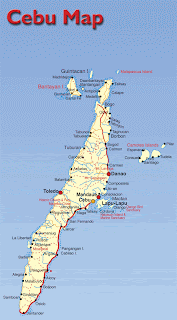
Cebu Island Maps
Cebu Island is one of the major islands of the Philippines. Along with some small peripheral islands, it forms Cebu Province. The island is also the central focal point and hub of the Visaya region of Philippines, with the provincial capital Cebu City serving as a major shipping port as well as port of ferry travel. To Cebu Island`s west lies Negoros island, and to its east lies Bohol and Leyte islands. Cebu is a long and narrow island, stretching 250 km from north to south, while being just 45 km wide.
As is evident from the Cebu Island maps below, most of the population lives in the coastal areas of the island. This is because of the mountainous terrain of the central areas of the island. The island`s total area is 4,468 square km, with a population of 3.6 million. But if we look at only the inhabitable coastal plain, then the population density becomes clearer. Driving along the coast of Cebu you encounter an almost endless stream of towns and villages. And Metro Cebu is a busy urban area with a population of 2.3 million.
Below are some Cebu Island maps.


Wednesday, June 16, 2010
Map of the Week-The Atlas of True Names
I missed the Atlas of True Names when it first came out almost two years ago but they now have an iPhone app so that gives me an excuse to talk about it. The Atlas takes the etymology of place names and translates their original meaning into modern English. London becomes "Unfordable River Town", San Francisco is "Saint Little Frank One", etc. Here is an iPhone screen shot of southern Africa.

When you click on a country, it gives you some etymology.

 Unfortunately, the Land of the People with Tall Caps did not make the iPhone map. This is from the world map detail on their web page. The area looks identical on the phone except for no people with tall caps. I want my money back!
There are some additional search and bookmark functions but that's mainly what you get for your $3.99. The World Map is nice but you don't get the level of detail that you get from some of the regional maps like their online example below. Hopefully that will be a future enhancement.


When you click on a country, it gives you some etymology.


There are some additional search and bookmark functions but that's mainly what you get for your $3.99. The World Map is nice but you don't get the level of detail that you get from some of the regional maps like their online example below. Hopefully that will be a future enhancement.

Monday, June 14, 2010
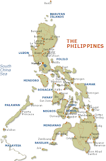
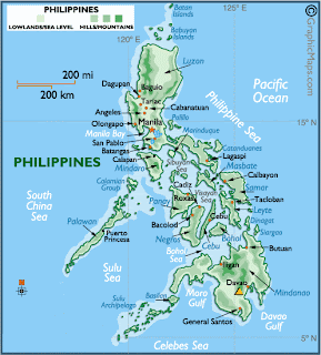
Philippines Maps
The Republic of Philippines is a country located in Southeast Asia, in the western area of the Pacific Ocean. It lies just south of Taiwan, east of Vietnam, and northeast of Indonesia. It is an island nationarchipelago consisting of 7,107 islands and occupying 300,000 square km (116,000 square mi) of land area (including its territorial waters). Its total coastline stretches on for 36,289 km (22,549 mi)
making it one of the countries with the longest coastlines in the world.
There are three main regions of Philippines: Luzon, the Visayas, and Mindanao. The Luzon island group includes the island of Luzon itself (the seat of Manila, and one of the most important islands in Philippines) along with some nearby peripheral islands. The Visayas consists of a number of major islands including Cebu, Panay, Negros, Bohol, Leyte, and Samar. The Mindanao island group includes the island of Mindanau itself, the second largest island in the country, as well as nearby peripheral islands.
Below are some Philippines maps for your reference.


Wednesday, June 9, 2010
Map of the Week-World Cup 2010
The 2010 World Cup in South Africa begins in 32 hours. Of course you will need some good maps to get you to the stadiums. Here is what I have been able to dig up. First, the official map from FIFA, it's kind of dull but you can click each city and get some basic information and a touristy picture for each place.

The 2010 World Cup in South Africa site has a prettier map with stadium pictures but what do those colors mean? Topography? Not exactly. Do the colors add anything useful to the map? Not exactly.

 At the more local level Map Studio has some excellent area maps showing the stadiums and nearby points of interest available on the Mappery site. Mappery has a nice interactive interface for browsing through their offerings.
Here are maps of Soccer City in Johannesburg and Moses Mabhita Stadium in Durban.


The 2010 World Cup in South Africa site has a prettier map with stadium pictures but what do those colors mean? Topography? Not exactly. Do the colors add anything useful to the map? Not exactly.
Here are maps of Soccer City in Johannesburg and Moses Mabhita Stadium in Durban.
Thursday, June 3, 2010
Map of the Week-Google Conquers Space!
In addition to knowing everything about you Google now has the Earth, the Sky, the Moon and Mars - in map form. Like Google Maps, Google Sky gives you an interactive mosaic of the visible universe. The images come from various sources, details can be found on their about page.

The buttons on the upper right give you the option to see infrared and microwave views, as well as overlaying a "historical" map from 1792 drawn by Giovanni Maria Cassini. The view below covers the same area as the one above.
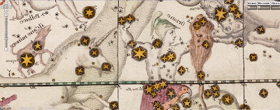
You can zoom, pan and click on things as well as selecting views, galaxies, planets and constellations from a gallery at the bottom of the page. Here is a view of the Crab Nebula.

In addition to the sky, you can also Google Moon and Google Mars.
Here is a view of the moon with imagery, charts and Apollo Landings overlaid.

Here is what the topographic chart option looks like.

Finally, here is an elevation image from Google Mars.

Subscribe to:
Posts (Atom)