Showing posts with label Africa Maps. Show all posts

Sunday, December 18, 2011

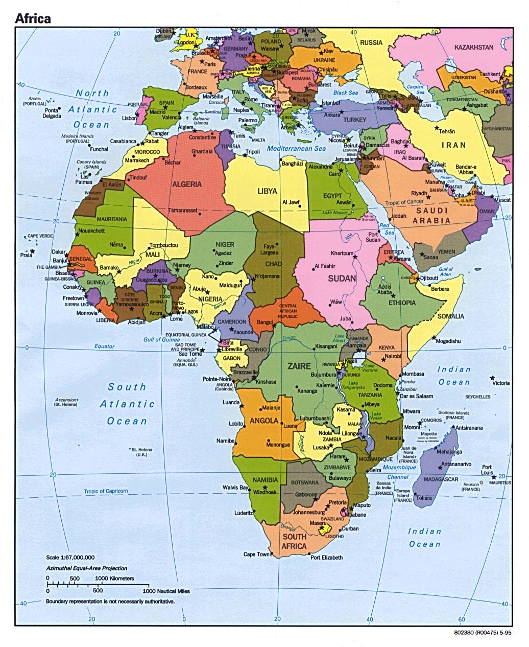
Political Map of Africa

Africa is the huge continent situated to the south of Europe. It is the second largest continent in the world, and has the second biggest population out of any continent in the world. Approximately 14.72% of the world`s population is in Africa. In specific numerical terms, that means around one billion people, similar to the population of India or China.

Africa is usually said to have 55 countries, which includes the disputed territory of Western Sahara (which is internationally recognized but is occupied by Morrocco). 48 of these countries are located on the mainland of the African contient, while 6 are island nations. It also includes the very new country of Southern Sudan.

The African Union includes 54 of the 55 internationally recognized African countries, with Morocco refusing to join because of the AU`s inclusion of Western Sahara.

There are other de facto nations with their own independently operating governments in Africa, specifically in the place we commonly know as Somalia. Only one government is internationally recognized in Somalia, but 2 de facto nations of Somaliland and Puntland exist in different areas of the country. The only thing that keeps Somaliland and Puntland from being on the political map of Africa is a lack of recognition by other countries. In practical terms, they are independent. This was the situation with South Sudan until its recent independence.


Here are some political Africa maps for your reference.

White political map of Africa
Africa Political map from Atlas

Update: Here is a 2012 political map of Africa that includes the world`s newest country: Southern Sudan.

2012 Political map of Africa with Southern Sudan

Friday, July 22, 2011

Map of South Sudan

South Sudan FlagAre you looking for a map of South Sudan? South Sudan is the world`s newest country, declaring its independence from Sudan on July 9th, 2011. The cessation of South Sudan is the result of a peace agreement stemming from the long civil war between the predominantly Arab northern Sudan, and the non-Arab tribes in the south.

The total size of the South Sudan nation is 644,329 sq km. The former size of the Sudan, from which South Sudan ceded, was 2,505,813 sq km (making it the largest country in Africa at the time), so South Sudan comprised approximately 25% of the land mass of the former Sudan. Sudan nows still controls 1,861,484 sq km, making it roughly three times larger than South Sudan.

The current boundary between the two countries is a provisional one and is not set in stone. Further negotiations over territory are set to take place. In particular, the status of the region of Abyei will be the direct subject of negotations between the two countries, so this disputed region may be shifted over toe South Sudan`s soveriegnty, or the land divided between the two countries. South Sudan maps are therefore subject to change in the future.

The population of South Sudan is 8,260,490. The capital city is Juba, with a population of approximately 250,000. The country is neighboured to the east by Ethiopia; to the southeast by Kenya; to the south by Uganda; to the southwest by Democratic Republic of Congo; to the west by Central African Republic; and of course to the north by Sudan. The Nile River runs through South Sudan and into Uganda.

I hope you find the following map of South Sudan useful.

This is South Sudan.

South Sudan maps

This is a map of the current borders of Sudan, post separation.

map of Sudan minus South Sudan

Tuesday, July 28, 2009

More Blank Africa Map

If you have browsed through the map categories over in the left sidebar then you may have seen an entry I posted last year called Blank Africa Outline Map. A lot of people visit that page, and several have recently contacted me to ask if I have any more similar blank Africa map files. I had to look around and find some, but I did find some and decided to post a follow-up entry with more blank Africa map images.

Another blank Africa map to print
A blank Africa political map for students to study with
Black and white blank Africa map files to print out
Check out this blank Africa map pic

I hope you found another blank Africa map, or several, that was helpful. Also, you can check out last year's similar entry Blank Africa Outline Map.

Friday, May 1, 2009

Map Of Cairo Egypt

Cairo, the capital of Egypt, is a massive metropolis and has the triple designation of being the largest city in Egypt, the largest city in Africa, and the largest city in the Arab World. It's population is around 12 million according to the 2008 census, but that number is not exactly reliable as nobody knows how many people are in Cairo without proper documentation or even an address. The metropolitan area has an estimated population of 17.8 million people.

The Nile River runs through Cairo, with the city center lying on the east bank of the river. Giza and the Giza pyramids lie on the west bank of the river and require you to cross a bridge.

I have been to Cairo twice, and it is an exciting city. But it can be a little overwhelming because of its sheer size, population density, and chaos. I personally enjoy that kind of overwhelming chaos, because it's something I can't experience at home.

The downsides to Cairo are pollution (if you wear sandles, you will come to your hotel with very dirty feet, and when you blow your nose black soot will come out), and con artists. Be careful of scams, anywhere in the city center but especially around Midan Tahrir. Be wary of people who approach you in the street -- they always want something from you.

But Cairo makes an amazing travel destination if you can't keep your wits about you.

Below you can find a map of Cairo Egypt.

Tourist Map of Cairo Egypt
Cairo Egypt Map
Cairo Street Map

I hope you found a Cairo Egypt map that was useful for you. Enjoy your trip to North Africa!

Wednesday, September 17, 2008

Physical Map Of North Africa

The Sahara Desert in Morocco, North Africa.

One of North Africa's defining topographical features is of course the great Sahara Desert, which occupies a full 90% of the region's land area. Another dominant feature is the Atlas mountains which extend along near the Mediterranean coast through Morocco, Algeria, and Tunisia. Following the Atlas mountain range to the west, it slowly becomes a steppe landscape that leads into the sands of the Sahara.

Of course another dominant feature of North Africa is the Nile River and Delta in Egypt, North Africa's most fertile area and where the majority of Egypt's population lives. Other relatively fertile areas include the Mediterranean coast, oases, and some valleys in the Atlas mountains.

Here I hope you can find a good physical map of North Africa for your further research.

A physical map of North Africa showing topographical features.

Physical map of North Africa taken by satellite photo.

A digital elevation physical map of North Africa.

Here you can find a physical map of Morocco, one of North Africa's important countries.

Physical map of Morocco shown with North Africa and Europe.

Mountain elevations in physical map of Morocco kingdom.

Physical map of Morocco's vegetation and elevation.

I trust you found this physical map of North Africa collection useful. Both its land and its people are fascinating and intriguing. Be sure to check back in the near future for more uploaded map colections. See you next time!

Saturday, September 13, 2008

Map Of Climate Of Africa

Map of African climate zones.A lot of people have the impression that Africa is all tropical rainforest or all savanna, but Africa displays a lot of climatic variation. Some regions are indeed tropical, but there are high mountain peaks in Africa that are snow-covered much of the year. The northern part of Africa is mostly desert, dominated by the great Sahara Desert. An strip of semi-desert followed by steppe separates the Sahara from sub-saharan Africa, where rainforests, deciduous forests, and savanna plains dominate. More semidesert and steppe is found in South Africa and east Africa, while the Namibian desert is found in southwest Africa.

Below you can find some map of African cliamte zones for further information.

Map of Climate of Africa showing land forms and vegetation types.

Map of African climate zones showing vegetation types.

Map of climate of Africa showing great detail.

I hope you found these map of climate of Africa useful and informative. I hope you will check back often for future updates!

Wednesday, September 10, 2008

Political Map Of North Africa

Image Hosted by ImageShack.usNorth Africa is the northernmost region of the African continent, lying north of and on the Sahara Desert. The exact definition of the area varies depending on which authority you ask, but the countries always included are the "Maghreb" countries of Morocco, Algeria, Tunisia, and Libya, plus Egypt. Western Sahara (mostly occupied by Morocco) is usually included, and Sudan is often included as well. Mauritania is sometimes included.

Interestingly, inside Moroccan territory, there are a serious of enclaves still belonging to Spain. Formerly called Spanish North Africa, and now called "Plazas de soberanía" (Sovereign Territories) they are Spanish-governed pieces of Africa. See the last map below.


I hope you find a political map of North Africa below that suits your needs.

Political map of North Africa and the Middle East in bold colors.

Politcal Map of North Africa showing Western Sahara, Morocco, Algeria, Tunisia, Libya, and Egypt.

Political map of North Africa extending down to central Africa.

Detailed political map of North Africa and the Middle East, meaning the Arab World.

Political map of Spanish North Africa, Plazas de soberanía

I hope the above political map of North Africa images were useful and informative for you. Be sure to check back often for more map collections of Africa, the Middle East, Europe, and many more.

Monday, September 8, 2008

Egypt Physical Map Images

Egypt physical map geography info for Middle East and North Africa studies.The Arab Republic of Egypt is located in North Africa, with the Sinai Peninsula located in Western Asia (the Suez Canal considered the dividing point between Africa and Asia. It is sometimes included in certain definitions of the Middle East, because of it's partial location in Asia. The Mediterranean Sea lies to the north of Egypt, while it borders Libya to the west, Israel and the Palestinian-controlled Gaza Strip to the northeast, the Red Sea to the east, and Sudan to the south.

Egypt is quite a large country with an area of 1,001,450 square kilometers (386,660 sq miles), but most of its population of 80 million live near the Nile River and delta, creating a densely populated narrow strip of arable land. The vast desert areas are sparsely populated.

Cairo, the massive capital city of Egypt, is both the largest city in Africa and in the entire Arab world.

Here you can find an Egypt physical map to become familiar with Egypt's geography.

Egypt physical map showing land features and elevations.

Egypt physical map showing size, elevation, and contours.

Egypt physical map showing oasis locations.

I hope these Egypt physical map files were useful. Check back often for new map collections from a variety of regions, including the Middle East and North Africa. See you soon!

Saturday, August 9, 2008

Printable Africa Map

Here you can print a map of Africa or download for free. These printable Africa map images are useful for your own geography related webpage, for your geography class, etc.

Facts about Africa:

* The largest country in Africa is Sudan, with an area of 2,505,800 sq km (967,490 sq mi).

* The largest city in Africa is Cairo, Egypt. It has a population of over 9 million.

* The highest mountain in Africa is Mount Kilimanjaro, in Tanzania. It's height is 5895m/19,340 ft.

* The longest river in Africa, and in the world, is the Nile River. It extends 6,650 km (4,132 miles), extending from the Nile Delta in Egypt to Ethiopia and Lake Victoria in Uganda (it splits into two sections).

Nice colorful printable Africa map showing political boundaries.

Black background solid color map of Africa printable for free.

Free printable political map of Africa with the equator marked. Kenya is highlighted

Beautiful solid color printable Africa map for teachers and geography students.

Classic atlas printable maps of the continent of Africa like this one.

White outline printable Africa map with political labelling, borders, etc.

Another similar but sleeker looking free printable political map of Africa in outline.

Lovely and easy to read printable Africa map for geography class, teachers, and students.

We hope you found these printable maps of Africa useful! Be sure to bookmark and check back often for new map updates and additions. See you soon!

Blank Africa Outline Map

Here is a selection of blank Africa outline map with labelling. These are useful if you want to add your own graphics or labelling. They're also good for geography tests! So all you teachers feel free to download them.

Africa is the world's second most populous continent (after Asia), with 922 million people, or 14.2% of the total. The earliest ancestors of humans are widely thought to have originated in the African continent.

A wide variety of climates and topographical features exist in Africa. The climate can be freezing on Africa's high mountains, tropical in the rainforest and coastal areas, and temperate in other areas. North Africa is primarily desert, while the southern part of Africa is mostly rainforest and savannah plains.

White blank Africa outline map for download and printable. Useful for your students' geography test!

All blue blank Africa map outline image.

Peach color Africa outline map with no country or feature labelling.

Small completely blank outline map of Africa with no border lines or labelling at all.

Africa Physical Map

Here you can find a downloadable Africa physical features map, showing the elevations and vegetation of the African continent.

Africa is 30.2 square kilometers in area (11.7 million square miles), making it the second largest continent. It covers approximately 6% of the Earth's surface, and just over 20% of it's total land area. To its north lies the Mediterranean Sea, to its northeast lies the Red Sea extending down to the horn of Africa, to its southeast lies the Indian Ocean, and to its west lies the Atlantic Ocean.


Great Africa physical map showing elevations and vegetation in green and brown.

Small Africa physical features map showing contours, with Mozambique emphasized.

Political and physical map of Africa showing borders and country names but also contours and land forms.

Another classic Africa physical map for people with geographic interests.

Satellite shot africa physical map from outer space.

Small but cool contour topographical Africa physical map for download.

We hope you found these Africa physical map downloads helpful and we encourage you to bookmark and check back for frequent updates.

Note that some of these maps have been shrunken so that they fit into the allotted space, but when you download them they should be full size.