Showing posts with label Korea Maps. Show all posts

Tuesday, February 7, 2012

Seoul Subway Map

Below you can find a useful Seoul subway map to help you with your travels and commuting.

The Seoul subway system is one of the most heavily ridden rapid transit systems on earth. With 6.77 million riders per day, it is slightly lower in ridership than the Tokyo subway system. It consists of 16 lines in total, with a whopping 546 stations.

The system is like a maze, and just glancing at the Seoul Metro map can cause vertigo. But thank God that all station signs in Seoul are written not only in Korean but also in English. Chinese characters, called Hanja in Korean, are often displayed as well.

Here is a Seoul Metro map in English, useful for travelers and expats.

Seoul Metro Map English

Here`s another Seoul Subway map, showing the same information. But I like the design and layout of this one better. It`s easier to follow this map.

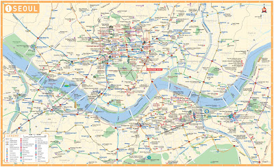
Seoul Subway map

Map of Seoul Korea

You can find a useful map of Seoul Korea down below.

Seoul is the largest city in the nation of Korea, as well as its capital city. It is a megacity on the scale of Tokyo or New York City, with a city population of over 10 million. Its metropolitan area has a population of over 25 million (which includes the nearby large city of Incheon, which shares Seoul`s international airport both in proximity and in name.

Seoul is located in the northern part of South Korea, and has 4 distinct seasons. The summers are hot and humid, with a rainy season in June and July (similar to Japan). Winters are cold and dry, with 28 days of snow per year on average. Averafe low temperatures reach -6 degrees celsius in January, with average highs only 1.5 degrees in the same month.

Here is a map of Seoul in English.

Seoul map English

This one is a map of Seoul labelled in Chinese characters.

Map of Seoul Chinese Characters

This one is a map of central Seoul.

Map of Seoul downtown