If you are looking for a
map of Isreal you can find some below. Israel is a small country in the Middle East, that was created from the British Mandate territory called Palestine. Isreal was created as a Jewish state, and the Westbank became administered by Jordan, and the Gaza Strip became administerd by Egypt. Jordan and Egypt's territories are now under partial Israeli occupation and partial Palestinian self rule.
Isreal (minus Gaza and the Westbank) has a total population of 7,465,000. The population is 75.4% Jewish, 20% Arab, and 4% other minorities including Russian immigrants of partial Jewish ancestry. The total land area of Isreal (minus all disputed territories) is only 20,770 square km. For comparison, that is about 2/3 the size of Vancouver Island. That makes Israel the 34th most densely populated country in the world with 356.8 people per square kilometer. This small size and high population density plays a roll in Isreal's territorial disputes with its neighbours.


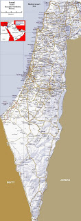
This road map of Israel shows lots of detail, but be careful because it does not show the borders of the Westbank and Gaza. In Israel those boundaries are not allowed to be printed on maps.
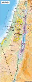
This map of Isreal shows the Palestinian autonomous areas. In yellow are areas theoretically under full Palestinian control. Nearby there are blue-green areas that represent Palestinian civil control and joint Israeli-Palestinian control of security. The other areas in between remain under full Israeli control. This map may be a little bit out of date because those areas continue to slowly change as Palestinians are given control over more land.
I hope you find the above maps of Israel and their explanations informative. Israel is a fascinating place where history is being made on a daily basis. I highly recommend you visit so you can see the situation firsthand.


