Showing posts with label history. Show all posts

Tuesday, March 13, 2012

Map of the Week-Burning Edition

Robert Ayres who created the burning Ponderosa map for Bonanza died recently.

This map is on permanent display at the Autry National Center in Los Angeles. Assuming that north is supposed to be up, the map was drawn incorrectly. When Ayres showed the map to series creator David Dortort he said "I love it, but your directions are wrong." Ayres fixed this by adding a compass with north pointing to the left and up. If only all cartographic problems could be solved this way.

Here's the map in action

For your viewing pleasure, here is the intro so you can watch it burn!


Thanks to my wife for the post suggestion and title.

Wednesday, February 15, 2012

The Pennsylvania Underground Railroad

To honor black history month, I went digging for maps. While the Underground Railroad is only a piece of that history, it has some of the most interesting map content. I came across this nice map of Underground Railroad sites around Kennett Square in Chester County, Pennsylvania. Quakers from the area were active in the abolitionist movement. The map is from the Kennett Square Underground Railroad Center.


A large print of the map is available here. Below is a detail:


I also found this schematic of the area from the website of Singing Wid a Sword in Ma Han  - a musical docudrama of the Underground Railroad in Pennsylvania playing in New York City.


For a complete picture of the Railroad's breadth, here is a map from Slavery in America.


Thursday, January 19, 2012

Gas Station Maps-The Early Days

According to Early Gulf Road Maps of Pennsylvania the Gulf Oil Corporation is usually credited with the first drive in gas station - on Baum Boulevard in Pittsburgh (where the company was headquartered) and the first freely distributed road maps.

Both of these credits are subject to debate - see footnote two from the article above, however the early oil company road maps were predominantly from Gulf. The first Gulf maps were made by W. B. Akins, a Pittsburgh advertising man. After a few years they switched to professional map making companies, first the American Blue Book Company, then Rand McNally and then H.M. Gousha after Harry Gousha left Rand McNally to start his own company.

Below are some details from a 1915 road map of Pennsylvania produced by the Automobile Blue Book Company and distributed by Gulf.


What is interesting (to me) about these maps is the importance of certain places (and lack of others) in the era before expressways.


The cover talks up "that good Gulf gasoline" and the "sterling qualities of this excellent petroleum product." It also advertises Supreme Auto Oil - "Its high viscosity renders it a perfect warm weather lubricant and its low cold test an Ideal Winter Oil, - as it flows freely at zero." 


In addition to road maps Gulf also distributed trip itinerary maps. Here are routes from Pittsburgh to Buffalo and Cleveland (marked in orange), with a listing of the places in between and the mileage. I like the quaint picture too.


Below is a 1917 "Half Day Tour" from Philadelphia to New Hope, Lambertville and Trenton. These tours list detailed routes but don't tell you what to see along the way or why you should go to places like Lambertville. They do tell you where to fill up your tank - in this case at the Gulf station at Broad and Hunting Park in North Philadelphia. Gulf only had seven stations in Pennsylvania and southern New Jersey at the time.


Of course I chose this tour for my own personal history. We lived in this area and took many of these trips.

Here is a 1925 Gulf map of parking regulations in downtown Pittsburgh. By then there were 14 Gulf stations in Pittsburgh. The takeaway from this map is to either try to find a space near the Point or on Congress St if you don't want to keep moving your car.


I will finish up with a detailed itinerary for the often changing Lincoln Highway, renamed Quebec Route 366 briefly in summer 2011. I have had inquiries about the specific route of this road - here it was in 1925. Street by street directions are listed for Pennsylvania. The New Jersey route is listed by town only.


Thanks to Historical Maps of Pennsylvania for the content of this post.

Thursday, December 22, 2011

The "Greatest Grid"

Yesterday I made a trip to the Museum of the City of New York to see The Greatest Grid. This exhibit celebrates the 200th anniversary of the Commissioner's Plan of 1811 that established the city's grid system. The exhibit is full of historic maps and the centerpiece is the Commissioners Plan Map of 1811 laid out on a glass covered table.


The grid was placed over the more sparsely settled areas above North Street (now Houston) without regard to the city's topography, water features or existing houses. Villages such as Harlem were eliminated to make room for straight streets. Houses that stood in the way (or even near the way) were demolished or moved. There is a section of the exhibit showing how houses were moved to accommodate the grid. This map from the exhibit's web site is one of many that show the land before the streets were built with the grid superimposed in light gray.


The exhibit starts with a video loop of residents proudly stating their address along the grid eg."125th and First!" After spending hours gawking at the maps you can go upstairs and see The Unfinished Grid, a collection of future design speculations resulting from a call for ideas from the Architectural League of New York. Many of these designs revolve around ways to break free from the grid's restrictions.

This collection of maps, photographs, newspaper clippings and other artifacts is very impressive and well worth a visit if you are in the New York metropolitan area. It runs through April 15th, 2012. The museum is located on the grid, at 5th and 103rd.

Thursday, December 15, 2011

Celebrating 150 Years of Italy Through Tables

Italy week continues with SESSANTUNA,  a collection of tables celebrating 150 years of Italian unity.


From the website of Cassina, the store that will be selling them:
SESSANTUNA is an art work consisting of 61 tables and designed as a historical retelling of Italy's unification. Every table, by Gaetano Pesce, is numbered in sequence according to the time when the state in question became part of the Union. Thus each one is historically relevant. The work also includes the smaller islands (Caprera, Elba, Lampedusa, Ischia, Ventotene and the Island of Montecristo), represented on a larger scale. The tables will be sold through an exclusive auction mechanism at the best Cassina stores (see the Where and How to purchase section).
The tables represent regional areas, not official regions or provinces. According to the site
the project is not meant as an accurate historical-geographical reconstruction of Risorgimento. 
Here are a couple of tables.

Molise, on the Adriatic coast


Immediately to the east is The Gargano, "Italy's Spur"


Tuesday, November 22, 2011

Native American Industry

Thanksgiving is a time to travel, shop, cook, watch the Cowboys lose and argue with your relatives. It is also a time to honor those who were here before we took their land. We may think of Native Americans in simplistic cliches, but the interior cultures had an extensive network of production and trade called the Hopewell Exchange System.

This map shows the extent of trade among the different cultures that flourished from about 200 BC to about 500 AD (or CE.) The map's author, Hieronymous Rowe has numerous maps of Native American culture on Wikipedia.

A few centuries later, members of the Mississippian Culture began quarrying chert, a stone used to make tools and ceremonial objects. The raw material was dug up and transported to nearby settlements to be made into hoes, spades and other tools. Here is Rowe's map of the production sites at Mill Creek, Illinois.


Tools were then traded extensively as seen here.

And you thought they only made turkeys and yams!

Wednesday, October 12, 2011

Map of the Week-Shipwrecks of the Delmarva

National Geographic features Shipwrecks of the Delmarva on their maps page. I never would have guessed that the chicken farms on Route 13 were perched on such treacherous soil. Here is a detailed view from the Zoomify interface.


From the web page:
Developed by renowned marine archaeologist and accomplished author Don Shomette, and designed by award-winning cartographer Robert Pratt, Shipwrecks of Delmarva is a stunning cartographic piece based on years of research and expert visual design.
I can't resist a few more detailed views.


The burning ship in this last one represents the amazing 2011 Phillies playoff run. Or maybe the gently sinking Rose is the better metaphor - it's just downstream from the stadium.

Wednesday, September 28, 2011

Franquelin's Map of Louisiana

Jean Baptiste Louis Franquelin was the first official cartographer in Canada. He mapped the interior of North America in great detail in order to bolster French claims to the region. In 1684, he prepared this remarkable map recording the explorations of Jolliet and La Salle. The map is one of the first to contain many common place names, most of which started as rivers, such as Chicago (Chekagou), Illinois (both a lake and a river), Wisconsin (R. Misconsing), Kansas (Cansa), Ohio and the Wabash (Ouabache) among others.


The original map has been lost. This later facsimile is available from the Library of Congress. Below is a detail showing the eastern Great Lakes, "La Pennsylvanie," "Virginie," and the Ohio River referred to as the "St. Louis" but with a tributary called Ohio.


The map shows the Mississippi River flowing west into Texas before reaching the Gulf of Mexico. According to Louisiana: European Exploration and the Louisiana Purchase (see page 14) from the Geography Division of the Library of Congress, the course of the river was fraudulently altered to gain royal support for a fort at its mouth. By being closer to Mexico, the fort would have been more economically viable by serving as a staging ground for incursions into Spanish territory and attacks on the silver mines of Mexico.

From the Geography Division publication:
Having gained French support for his project, La Salle attempted to return to the Mississippi by way of the Gulf Coast in 1684-85, but his ships missed the mouth of the river and the expedition landed at Matagorda Bay, Texas. Two years of starvation and disease followed and subsequently a mutiny took his life. La Salle failed to establish a permanent colony in the lower Mississippi Valley but he did plant French claims over the vast region that eventually became the Louisiana Purchase.

Tuesday, July 19, 2011

Detroit - the Woodward Plan

There's a lot of good cartographic content on flickr. I was looking for something else on a flickr group titled The Paper Cites- Speculative and Unbuilt Structures, when I came across this image from a user who calls himself whitewall buick. It shows the "Governor and Judges' Plan" for Detroit after the1805 fire destroyed the city. This plan was based on L'Enfant's plan for Washington DC with a series of plazas and wide boulevards radiating outwards. The shaded area is what was actually implemented.

According to the poster, the remaining areas grew haphazardly because the city was not given the authority to force private landowners to subdivide their land according to the plan. Unfortunately much of the content on flickr is poorly attributed and he does not give much more information.

Here is a map the current street network (and what was ruined) from Detroit Yes! I suspect this map is a bit out of date because it does not show the Campus Martius Park (see below.)


Michigan Territory Chief Justice Augustus B. Woodward proposed a plan of hexagonal blocks with the Grand Circus as the central point.


The Campus Martius, a few blocks south of the Grand Circus, is the point of origin for Michigan's coordinate system of roads that includes the Seven and Eight Mile roads located at those distances away.

Here is a photo of the point of origin marker. Campus Martius Park has recently been redeveloped into a very popular city park with fountains, performance spaces and an ice skating rink.

Wednesday, May 25, 2011

Satellite Images Reveal Lost Eqyptian Sites

A new satellite survey of Egypt using infrared sensors with submeter resolution has revealed thousands of tombs and settlements that are buried under silt in the Nile Delta region. A team, led by Egyptologist Dr. Sarah Parcak, Ph.D. is using the imagery to locate future excavation sites. The infrared band of the spectrum enables analysts to distinguish building materials from the surrounding soil. This image forms a streetmap of the ancient city of Tanis - a much larger city than many people expected to see.


Is that the world's first expressway cloverleaf in the northwest corner?

For a regional perspective use this BBC map.


The imagery also reveals where and when sites have been looted so authorities can be on the lookout for antiquities that appear for sale. More details and a video can be found on the BBC and a program, Egypt's Lost Cities will be aired Monday on BBC One. 

Thursday, March 31, 2011

Maps in Unexpected Places-Savannah Part 1

We just got back from a trip to Savannah, Georgia and saw a few interesting maps in unexpected places. This map, the first of two that I plan to spotlight, is embossed on both awnings of the new Sylvester & Co. Modern General store on Broughton Street downtown.


Here is a close up of one of the awnings. The black on gold is very striking and closely reflects the original map colors.


The map is titled "Plan of the City & Harbour of Savannah, in Chatham County. State of Georgia. A.D. 1818." It is from the "Report on the Social Statistics of Cities," compiled by George E. Waring, Jr., United States. Census Office, Part II, 1886. The map can be found online at the Perry-Castenada Library Map Collection at the University of Texas. Click below for a detailed view.


Savannah was founded in 1733 by General James Oglethorpe, who laid the city with six squares. As the city expanded more squares were added at regular intervals until there were 24. 22 of these squares still exist today in a National Historic Landmark District. These squares give the city a unique feel and charm. Major historic preservation and landscaping efforts protect the scenic and inviting character of the district.

This map, from 1818 shows the first 15 squares, with the area south of Liberty Street still undeveloped and listed as the "City Common." An empty space is cleared for Crawford Square, which sits on a "line of defense thrown up in 1814"  along the perimeter of the city.

Map 2 from Savannah will be featured in an upcoming post.


Monday, January 17, 2011

Happy MLK Day!

The Martin Luther King, Jr., National Historic Site in Atlanta consists of several buildings, including the house he was born, the Ebenezer Baptist Church where he was a pastor, his tomb and the King Center. Here is a detail from the National Parks Service map that can be found on this page:


Wednesday, November 17, 2010

Mapping Gothic France

My brother discovered the Mapping Gothic France website at a lecture. The site is dense with interactivity. The main interface allows you to overlay various historic maps with your choice of current base maps, click on churches and buildings and connect to more information than you can possibly absorb in one viewing.


Like a chef you can mix and match your ingredients as you see fit-below you can see King Philip II invading Normandy over a tasty layer of road map.


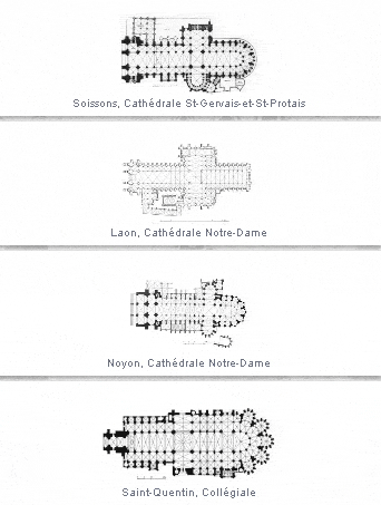
There are timelines, links to authors, stories and essays and lots of information about churches. Each church has its own page with images 360 degree panoramas and stereoscopic views (though I could not get those to load) that require 3D glasses. For dessert, some screen shots from a panel that allows you to select churches and compare images and floor plans.


Wednesday, October 20, 2010

Cigarette Card Maps

Cigarette manufacturers began including cards in their packages in the mid to late 1800's. Issuing cards in a series enticed buyers to stick with the same brand. The cards showed popular actors, sports figures, animals, plants and a host of other subjects including maps.

The New York Public Library has a large collection of these cards viewable from their Digital Gallery.

Churchman's Cigarettes produced a "How to Make a Map" series for boy scouts. Here are some of their cards with the text that appears on the back.


 "Scouts should first practice observation, and notice all the landmarks (such as hills, churches, trees, rocks, gates and bridges), so that, if necessary, they may draw an accurate map of the surrounding country. The four points of the compass should always be put in, and it is a very great convenience when a map can be, as nearly as possible, drawn to scale."


"It is a difficult matter for a scout to accurately draw a map of water, This, however needs only a little practice and a perfect knowledge of the different signs agreed upon to represent the different boats. The specimen given at the recto is a very good one, showing a very complete map of a village in the vicinity of water. The letters P. T. signify that the village possesses both post and telegraph office."

Gallagher, LTD also issued a "How to Make a Map" card. Here is the front and back of the card.


Map Reading Class was also a card subject.


Some cards depicted airline routes. Here is the route from England to South Africa.

 
Finally, a "Map of London and the Home Counties" was cut into pieces to be collected and reassembled. Here are two matching pieces.

No. 4. Digital ID: 1610435. New York Public LibraryNo. 3. Digital ID: 1610433. New York Public Library