Showing posts with label hand drawn maps. Show all posts

Thursday, March 29, 2012

Random Thursday-Maps You Probably Won't Use Today

Have I mentioned that I don't really care for google (or bing or yahoo) maps? Sure they serve certain purposes very well and I even use them at work when they fit the bill. However, when directing me to your business I prefer a customized map. Here are some examples.

A map to the Kipu Ranch on Kauai where you can enjoy scenic beauty by ramming through it on an ATV.
Directions to Camp del Oro in Nevada City, California. You will probably get lost.


Raffles, an Asian restaurant in Nagoya, Japan. An Asian restaurant in Japan? What an idea!


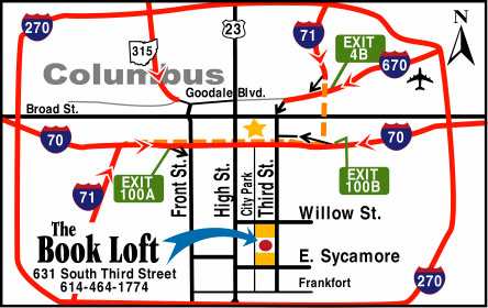
The Book Loft of German Village - Columbus, Ohio. Absolutely not to scale but emphasizing the important details - and you can't do that in google!


Pasquia Regional Park in Saskatchewan- looks like it was drawn by a kid with cartographic skills.


A very red map of the locations of the Big R Stores in the Northwestern US. I love how the topography ends at the Idaho border!

Here's a map to The Strand - a development in Datarang Sunway, Malaysia. I got the image from Three Meals of Goodness, a Malaysian dining blog. I like the exaggerated earth curvature, and the Ikea.


Wednesday, March 21, 2012

A Six Pack of Maps

Spring beer season is here. If you look at the bottom of your six pack you may find a nice map directing you to the brewery. Just be careful not to turn it over when it's full of bottles. I like these maps because they are usually hand drawn (or in a hand drawn style) making for creative alternatives to the googly, bingy maps we've become accustomed to. Of course, most brewing companies use a google type map on their web sites so I had to scan some six packs.

Here are six examples from beers that are commonly available here in the Northeastern USA. I have a few others from farther afield that will make for a future post. This is not meant as an endorsement of these beers. They are just the ones I've bought in six packs recently and some of them were better than others.

From Maine - the Belfast Bay Brewing Company.

Magic Hat in South Burlington, Vermont. I've actually been on this tour!


Victory - Downingtown, PA. A highly schematic map where 202 and 30 are really important while 476 and Route 1 don't make the cut.

While in Pennsylvania stop by Troegs - look for a beer bottle by the railroad tracks. They're moving to Hershey* though so this map may not help you anymore.


Circling up to western New York, there's the Southern Tier Brewing Company.

Finally we head back eastwards for a colorful map from the Ithaca Beer Company.


If you find a nice map on the bottom of your six pack send it over and maybe I'll put it in a future post.

*UPDATE - since I began collecting these Troeg's has in fact moved so I had to buy another six pack of their beer. Here's the map to their new digs with I-81's westward sweep greatly exaggerated for artistic effect - try doing that on a google map!


Wednesday, February 15, 2012

The Pennsylvania Underground Railroad

To honor black history month, I went digging for maps. While the Underground Railroad is only a piece of that history, it has some of the most interesting map content. I came across this nice map of Underground Railroad sites around Kennett Square in Chester County, Pennsylvania. Quakers from the area were active in the abolitionist movement. The map is from the Kennett Square Underground Railroad Center.


A large print of the map is available here. Below is a detail:


I also found this schematic of the area from the website of Singing Wid a Sword in Ma Han  - a musical docudrama of the Underground Railroad in Pennsylvania playing in New York City.


For a complete picture of the Railroad's breadth, here is a map from Slavery in America.


Wednesday, February 1, 2012

Maps from Memory

Illustrator Ellis Nadler started a group on flickr for maps drawn From Memory. There's a nice variety of artistry and accuracy here. One of the better ones is Montreal de memoire from Axel Drainville.


User 4ojos has some very nice maps on flickr. Here's Goa.

 
For some enjoyable inaccuracy here is the Nadler's Brazil featuring Rio on the wrong side of the Amazon and in the wrong hemisphere.

Brazil map from memory

His Australia's a little off too...

australia map from memory

...but not as bad as the one drawn by his "highly educated" friend.

Australia map from memory

Nadler simplifies London in case you get lost.
Map from memory

Here's his solar system in case you get lost there.
Map of solar system from memory

There's many more fun maps on this group so go waste some quality time! 

Wednesday, May 11, 2011

London Mapping Festival!

The London Mapping Festival is an 18 month program(me) of activities that will eventually coincide with the 2012 Olympics. The official launch event is June 6th, however activities have already begun with an exhibit of hand drawn maps at the Museum of London. Readers of the Londonist have submitted their own entries shown online here. Some examples:
"Selected Loos of London."
"Brixton as a Tree"


Artist Alexander6's "super-swanky map of Mayfair and all of the area’s ridiculously over-priced luxury stuff..."

Many more can be found in their online archive.

Wednesday, December 1, 2010

Holiday Books and Exhibit

I will now proceed to discuss two books I have not read yet and one exhibit I haven't been to yet. After all, this is the internet where you just say stuff!

The Hand Drawn Map Association (HDMA) has a book out entitled From Here to There: A Curious Collection from the Hand Drawn Map Association.

Those of you in the Philadelphia area can see a parallel exhibit of their maps called No where at Arcadia University in Glenside, PA.

The exhibit only goes until December 19th so hurry up!


Here are some maps in the exhibit lifted from Kris Harzinski's website. Harzinski is the founder of the HDMA and an artist from the semi-hip Fishtown neighborhood of Philadelphia.

Perry Steindel, Untitled, 1965.

Scott Griffith, Window map of Anchorage, 2010.

****************************************************************
Mapping America is a follow up to the Mapping New York book featured previously. Once again Black Dog Publishing is offering a 40% discount for readers of this blog. For the discount send an e-mail to Jess Atkins jess@blackdogonline.com

Here are some sample images.

Detail from a pictorial Wildlife and Game map from 1956.

"Dissected Map of the United States" by Rev. E. J. Clemens, 1893. This is the box of a jigsaw puzzle meant to teach geography. The American figure is handing out pieces to grateful representatives of various foreign countries. On the back is an ad for Sherwin Williams paint.

Finally, I will leave you with this heart-warming image- "States United", a poster by Greg Beauchamp, 2009.


I like the legend at the bottom of the poster.


Tuesday, October 5, 2010

What is Map of the Week?

Today is the fifth anniversary of Map of the Week! Sort of. Actually it's more complicated than that as most things are. An exact anniversary date is tough to pin down so today is as good as any. Here's the boring history lesson:

Map of the Week started in or around 1993 when I shared a house in Lawrence, Kansas with fellow graduate student, frequent commenter and Renaissance blogger Michael5000. We started putting maps of the week on the kitchen wall (or maybe fridge I can't remember everything from those crazy college days.)  They were not exotic or special - just maps that we felt like posting and the practice didn't stick for very long because we had homework and life to attend to.

When I accepted a job in Seattle, a place I'd never been, I drew this mental map based on my limited knowledge and probably posted it as a final map of the week. The map suffers from the classic "figure ground" problem-the water looks like land and vice versa. The original is on yellow paper, printed on the back of a lost dog notice.


On occasion I would send Mr. 5000 maps in the US mail that I found to be noteworthy. Here is a map from a charity newsletter of a project they did in Moncton, New Brunswick. I clipped out the charity's name to spare them the embarrassment as they do some very good work.


The map is pretty tough to read from my poor copy but basically they didn't know where Moncton or New Brunswick were so they just plopped it right in the middle of the country. That's OK - Canada's a small place!

Years later (around 2004 or so) I decided to revive Map of the Week as a weekly e-mail with a map attached. Five years ago today I started keeping track of what map I posted on what date with an eye towards a possible blog. I finally created the blog in 2007 and began by back posting all my entries beginning October 5th, 2005. As of today the blog has reached over 150 countries!

Map of the Week will try to continue to bring a quality blog product every week, with the occasional extra map of the weekend or other special event. Map of the Week will not advertise your book, or map products but if something looks interesting, I may post it without the sales pitch. Thanks to all my readers for years of support!

Wednesday, March 25, 2009

Map of the Week - Jimmy Corrigan's World

I've looked at this site many times and still don't completely get it. It's an interactive promotion for Chris Ware's graphic novel Jimmy Corrigan: The Smartest Boy on Earth. I have not read it, but the story here does not appear to follow the book as described online. It does make an interesting use of maps to tell a story. Click the map below and then the lower arrow. Next click on one of the circles on the globe and you get a piece of the story.

This a typical immigrant coming to the US to find whatever opportunities are out there story. If you really want to follow it the trick is to click on what's supposed to be Tennessee but really is too far south and east. Then click the right arrows. There seem to be parallel stories about slavery and some traffic accident in Panama. Again, the relationship to this graphic novel is unclear. Below is a typical sequence showing parts of the story.


If you click on Chicago you get this nice little zoom in sequence


The site does work in that it makes me curious to read the story. Then again after months of looking I have yet to actually place my order.

Thursday, November 8, 2007

Map of the Week #99 - [murmur]

Murmur (excuse me it's [murmur]) is a cool multimedia project established in Toronto. You can click the link below, choose a neighborhood and bring up a "mental map" such as below. Clicking the red dots will bring up audio files that are stories told by everyday people who have a connection to those locations. Below is their own description of the project:

[murmur] is a documentary oral history project that records stories and memories told about specific geographic locations. We collect and make accessible people's personal histories and anecdotes about the places in their neighborhoods that are important to them. In each of these locations we install a [murmur] sign with a telephone number on it that anyone can call with a mobile phone to listen to that story while standing in that exact spot, and engaging in the physical experience of being right where the story takes place. Some stories suggest that the listener walk around, following a certain path through a place, while others allow a person to wander with both their feet and their gaze.
The stories we record range from personal recollections to more "historic" stories, or sometimes both -- but always are told from a personal point of view, as if the storyteller is just out for a stroll and was casually talking about their neighbourhood to a friend.

Thursday, August 17, 2006

Thursday, May 25, 2006

MOTW #31

Another set of maps from the Lori Napoleon collection Her description:
"Providence, Rhode Island.

This amazingly illustrated map was one of the many maps that were submitted to me at the Psy-Geo Provflux, held at the steelyard seen on the left. Art exhibits/installations were spread throughout the entire lot; an adobe hut, a greenhouse, many rooms and nooks inside the warehouse. The space that i was given to do my maps installation was a wonderful, musty room with exposed brick walls and a long industrial sink in the center. I affixed my collection according to different categories all around this room, and spent the entire night - (complete with numerous coffee/processed food breaks) and on to the morning, completing the installation. I became really immersed in that room and felt very at home with the freedom to create and arrange, all while the other PIPsters worked aduously on the cleaning, arranging, and painting of the exhibition spaces. the amount of work and care put into the show was incredible, and i am lucky to have been able to be a part of it, to go to Providence where this map originated from. Highlights on the map include the steel mill, some neighborhood architecture, and a very interesting public interference on college hill. "

Here's another from the same exhibit showing the way to the "Mafia Gym"

Friday, November 18, 2005

MOTW #7

This is part of the CD cover for "My Buzz Comes Back" from Philly hip-hoppers Slo-Mo and Mic Wrecka. They have a really cool mental map of the Northern Liberties neighborhood in Philadelphia. Oh and the music's darn good too.


Wednesday, October 12, 2005

MOTW #2

I'm pretty sure this came from Lori Napoleon's wonderful collection of "mental maps".