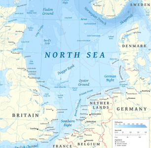
The North Sea is part of the Atlantic Ocean, situated between Scandinavia, Germany, the Netherlands, Belgium, and Great Britain. It is connected to the ocean via the English Channel and the Norwegian Sea.
It is a large sea that stretches more than 970 km long (that`s 600 miles for you Americans), and 580 km wide (around 360 miles). Its total surface area is about 750,000 square km (290,000 square miles). Most of the sea has a shallow depth of only 90 meters - around 300 feet.
There are numerous islands and archipelagos in the North Sea, like the Shetland islands, Orkney, and the Frisian Islands.
Hello viewers I don't have much to say, there are so many scammers going on online so we cant detect the real herbal medicine doctors. Thank GOD for leading me, please don't ignore this post it's real, Dr Lucky is a real herbal Doctor, he cured me from Herpes virus, i am living so happy and free, i was fully recovered within 2 weeks of usage by Dr Lucky herbal medicine, please viewers out there that have any deadly disease don't fail to contact him GOD bless you abundantly he also cured HIV/AIDS,CANCER,GENITAL WART,COPD,BRAIN TUMOR, Inbox the great healer on Him email; drluckyherbalcure@gmail.com or WhatsApp/Call; +2348154637647
ReplyDelete