Showing posts with label arctic. Show all posts

Wednesday, November 2, 2011

Melting Sea Ice in the Arctic Ocean

Ice in the Arctic Ocean is melting faster than climate models have predicted. A recent article from The Economist looks at the causes. Included is this map comparing average and recent sea ice extents.


The article also links to an animation that shows the opening up of potential new shipping routes - also shown on the map above. Here is a still frame.


Some interesting notes from the article:

Melting ice creates a "feedback loop" where there is more water and less ice. Water absorbs light and heat, while ice reflects it. More water and less ice means more heat is retained.

Melting ice will enable the extraction of more fossil fuel from the area, creating another feedback loop in which more greenhouse gas emissions will be created.

The melting of the ocean ice will do little to raise the sea level, however eventually more ice will melt off of Greenland and other land areas and that will cause a sea level rise.

Wednesday, August 17, 2011

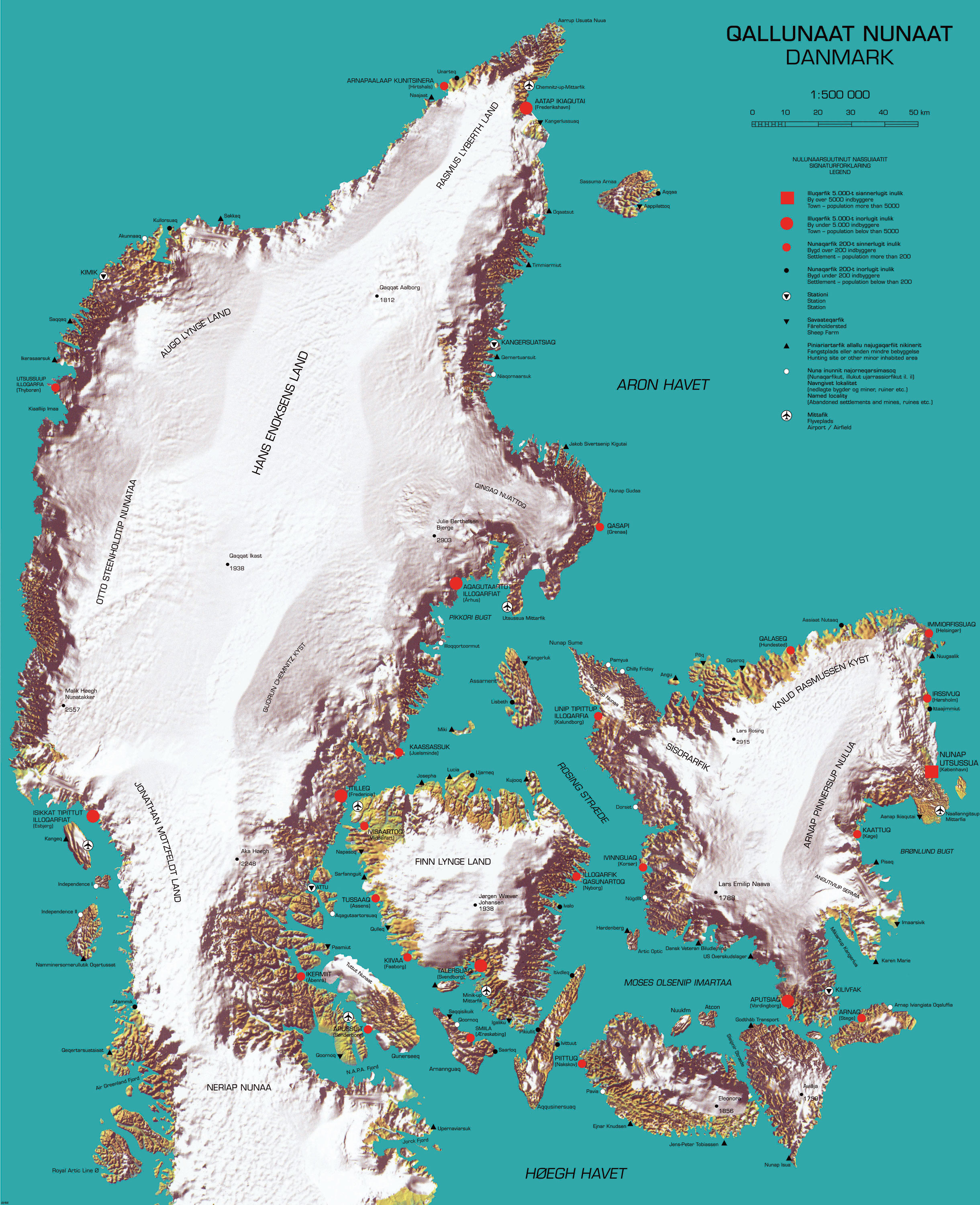
Map of the Week - Reverse Colonialism

Here is a "cool" map that recently appeared on Strange Maps. It was produced by cinematographer and multimedia artist Inuk Silis Høegh for a project called "Melting Barricades," part of the  Rethinking Nordic Colonialism exhibit. The map pictures Denmark being colonized by Greenland, not just by the people but also by climate and topography.


Greenlandic names are imposed on places with the native Danish names in parentheses. The country name and title of the map is Qallunaat Nunaat (Danmark) and its largest city is Nunap Utsussua (København.) The coastline has become jagged from glacial erosion and the frozen interior named after native Greenlanders. The author also appears to have named a strait after himself, the Høegh Havet. 

There are a lot of details that escape me because I don't speak either of the languages and don't know my Illuqarfiks from my Nunaqarfiks. Some understandable (to English speakers) place names include "Chilly Friday" and "Air Greenland Fjord." 


Høegh also made a video called Attack-atigiit showing the Greenlandic occupation of Denmark. The language barrier prevents me from all the clever details but the general picture is clear. Below are some stills. The first one shows quizzical Danes studying the above map. At least I think that's the idea.


In this one Greenland is shown on a world map as a Mercator Giant, planting its flags around the world.


Thursday, January 24, 2008

Map of the Week 109-Russian Claims in the Arctic

Put in your claim before it's too late! This is an excerpt from a story that appeared on the BBC this past August (2007). The text below the map explains the numbers.

"The Russians are leading a new 'gold rush' in the high north, with a bold attempt to assert a claim to oil, gas and mineral rights over large parts of the Arctic Ocean up to the North Pole."


1) North Pole: Russia leaves its flag on the seabed, 4,000m (13,100ft) beneath the surface, as part of its claims for oil and gas reserves
2) Lomonosov Ridge: Russia argues that this underwater feature is an extension of its continental territory and is looking for evidence
3) 200-nautical mile (370km) line: Shows how far countries' agreed economic area extends beyond their coastline. Often set from outlying islands
4) Russian-claimed territory: The bid to claim a vast area is being closely watched by other countries. Some could follow suit

Some interesting solutions that appear in this story:

The "median line method", supported by Canada and Denmark, would divide the Arctic waters between countries according to their length of nearest coastline. This would give Denmark the Pole itself but Canada would gain as well.

The "sector method" would take the North Pole as the centre and draw lines south along longitudes. This would penalise Canada but Norway and, to a lesser extent, Russia, would gain.