Showing posts with label georgia. Show all posts

Wednesday, April 20, 2011

Maps in Unexpected Places-Savannah Part 2

As promised here is part 2 of the Savannah edition of Maps in Unexpected Places.
Vic's on the River is a restaurant in an old warehouse, that was used by General Sherman's officers as a planning space. The main dining room showcases a map drawn by Union soldiers in the Civil War detailing Sherman's march from Tennessee through Georgia. The map was discovered during a renovation drawn onto the wall. For protection, it is framed under glass. The romantic dining lighting is poor for photography but here are some pictures I attempted. I can't find any good images of this map online so these photos are the best I have. First, the explanatory text.


The northern part of the map shows Chattanooga, Lookout Mountain, and the Georgia, Tennessee border region.


Lookout Mountain.


Some details a little further east. 


Oh and by the way, the food is excellent, too. Come for the map, stay for dinner.

Thursday, March 31, 2011

Maps in Unexpected Places-Savannah Part 1

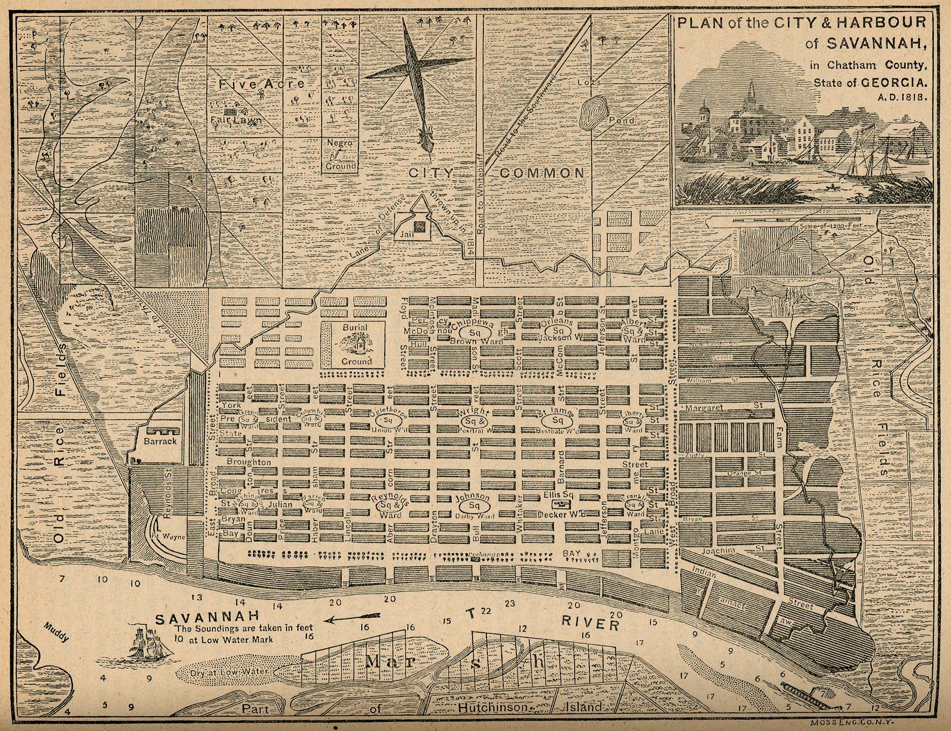
We just got back from a trip to Savannah, Georgia and saw a few interesting maps in unexpected places. This map, the first of two that I plan to spotlight, is embossed on both awnings of the new Sylvester & Co. Modern General store on Broughton Street downtown.


Here is a close up of one of the awnings. The black on gold is very striking and closely reflects the original map colors.


The map is titled "Plan of the City & Harbour of Savannah, in Chatham County. State of Georgia. A.D. 1818." It is from the "Report on the Social Statistics of Cities," compiled by George E. Waring, Jr., United States. Census Office, Part II, 1886. The map can be found online at the Perry-Castenada Library Map Collection at the University of Texas. Click below for a detailed view.


Savannah was founded in 1733 by General James Oglethorpe, who laid the city with six squares. As the city expanded more squares were added at regular intervals until there were 24. 22 of these squares still exist today in a National Historic Landmark District. These squares give the city a unique feel and charm. Major historic preservation and landscaping efforts protect the scenic and inviting character of the district.

This map, from 1818 shows the first 15 squares, with the area south of Liberty Street still undeveloped and listed as the "City Common." An empty space is cleared for Crawford Square, which sits on a "line of defense thrown up in 1814"  along the perimeter of the city.

Map 2 from Savannah will be featured in an upcoming post.


Wednesday, August 13, 2008

Map of the Week - Georgia's Abkhazian and Ossetian Problems

It's been tough finding good maps that really show what's going on in the Caucasus region. This CIA map illustrates why the South Ossetian and Abkhazian people want independence from Georgia - though I'm not sure that being a part of Russia is really what they want either. The Abkhaz are linguistically unique while the Ossetians not only have a different language but are also not considered to be "Caucasian". The map nicely illustrates how difficult it would be to create contiguous countries in the region. Also note the proximity of other recent spots of conflict such as Chechnya, Dagestan and Nagorno-Karabakh in Azerbaijan. There are a couple of versions of this map on the web but Wikipedia has the best one I've seen.

For a nice, detailed general reference map of the region click here.

This is an interesting historical map of the region produced by American cartographer Thomas Bradford in 1835. Clicking the image will bring up a window so you can zoom and pan to get more detail.