
Showing posts with label massachusetts. Show all posts
Showing posts with label massachusetts. Show all posts
Sunday, December 25, 2011
Friday, November 12, 2010
Map of the Weekend-Cape Shot
It's the weekend. Time to find your favorite map shot glass and drink a toast!


Wednesday, November 3, 2010
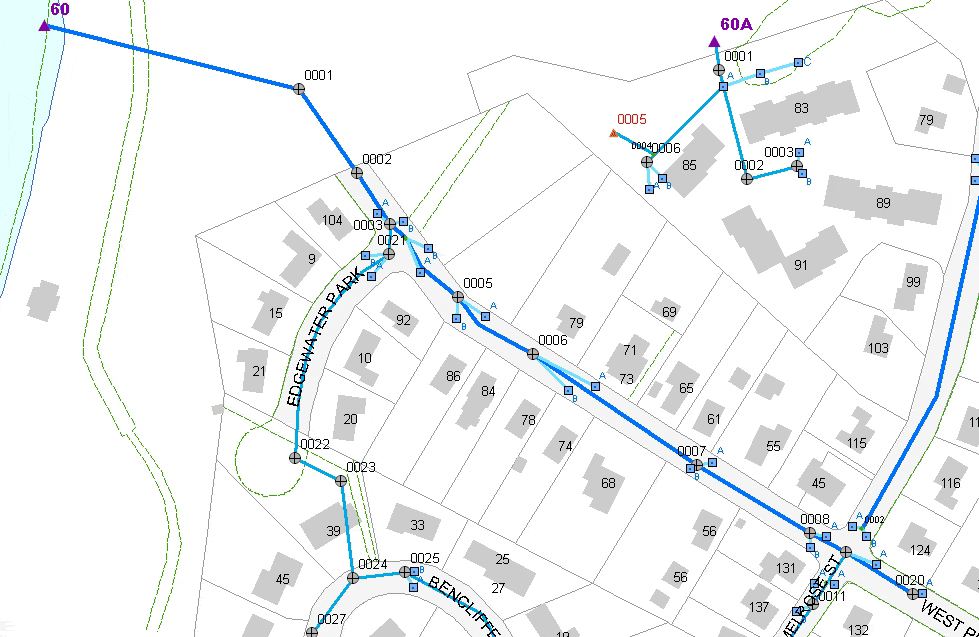
What I do for a Living-Part 1
Things are really busy for me this week. We have a big infrastructure evaluation project that I need to map and analyze every which way. Since I don't really have the time for an interesting, well researched post, here are some storm drainage pipes somewhere in Massachusetts. This is what I do in my non-spare time.

Wednesday, September 15, 2010
Map of the Week-Mainegon and Wiscachusetts
Next week I will be traveling to Portland for a workshop.
If I use Andy Woodruff's map of Portland I should be able to find my way, right?

Maybe on the way up there I'll stop in Madbridge, Wiscachusetts. Here is a detailed street map.

If I use Andy Woodruff's map of Portland I should be able to find my way, right?
Maybe on the way up there I'll stop in Madbridge, Wiscachusetts. Here is a detailed street map.
Sunday, August 16, 2009
Where in the World is (was) John Quincy Adams?
John Quincy Adams is on Twitter! He has over 13,000 followers! The Massachusetts Historical Society has been recounting his voyage as a diplomat to Russia 200 years ago, before he became the sixth president of the United States (1825-1829). His 200 year old diary entries are released daily as "tweets" - and you can follow his progress on google maps. He sailed from Boston to Denmark and then to St. Petersburg. As of Saturday he was just heading out into open sea.
8/15/1809: Weather fine- wind scanty. Lat: 44-13. Long: 53-40. This afternoon I found the Caboose on fire.

8/15/1809: Weather fine- wind scanty. Lat: 44-13. Long: 53-40. This afternoon I found the Caboose on fire.

Thursday, April 16, 2009
Map of the Week-Patriot's Day Edition
Monday is Patriot's Day here in Massachusetts. We commemorate the first revolutionary war battles by taking a day off from work and re-enacting these battles. We also have related activities like a morning Red Sox game, a marathon, drinking beer out of paper bags on the T and bragging about our "wicked awesome" sports teams. Here is a map of the activities of April 19th, 1775 - some of it happened right down the street from me.
 Thanks to the Department of Military Science at Worcester Polytechnic Institute for the map. Their timeline of events (and this map) can be found here.
 Thanks to the Department of Military Science at Worcester Polytechnic Institute for the map. Their timeline of events (and this map) can be found here.
 Thursday, December 4, 2008
The Daily Masshole Obstacle Course
I frequently complain about my commute. Yes it's "only" 8 miles but 8 miles of stress. It is much more stressful than my job and probably the main thing that leaves me drained at night. In addition to the usual problems of heavy traffic, construction, bad roads and "Masshole" drivers, the route itself is a crazy serpentine pattern-there is no straight line to get me there.
Below is a map of my route through eastern Massachusetts. I've generalized it a bit and left off place names to make it less obvious where I live and work. Green text indicates southbound issues, purple northbound and black means the problem is in both directions.
 The 8 mile route takes me 25 minutes with no traffic, 35-40 minutes typically and can be up to an hour in bad traffic situations. I can ride my bicycle there in 40-45 minutes when I don't get whacked. Public transit is a 3 bus system and takes an hour and 20 minutes. Walking? I haven't tried that one yet.
Subscribe to:
Posts (Atom)