Showing posts with label fake places. Show all posts

Friday, December 2, 2011

December Map Crafts

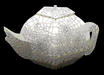
Emily Garfield is a Boston area artist who creates "imaginary cartography." She will be showing her work in several area venues starting this weekend. Here are some of her maps - I have a few small prints of these.


Here is her Map Teapot, on display at Mobilia Gallery in Cambridge.

A short hop to the other side of the country will get you to the 23 Sandy Gallery in Portland, Oregon to see a globe exhibit called Welcome to My World - opening tonight!


Below is a work called "Underworld" by book artist and friend of the Map of the Week family, Susan Collard.


Several of the globes take on Global Warming as a theme. My favorite is this one by Bonnie Meltzer.


Finally, I'll leave you with Rebecca's Room by David Chelsea- acrylic paint on globe.


Wednesday, November 9, 2011

The Web 2.0 Map

In the last couple of years I've seen many attempts to show the internet using a metaphoric map. Most of those attempts have not held my interest and left me confused. The Web 2.0 Map is also confusing (after all the web itself is a confusing place) but it captured my interest because it is attractive, well organized and interactive. You can pan and zoom and also click the icons for further information.


The map is like a Risk board with icons for the primary players in the industry. If you click on them you get a somewhat advertise-y description of each one. As you zoom in more companies appear on the map. It is built on Google's mapping API and is organized from north to south with the "Clouds of Infrastructure" then the "Oceans of OS and UI", the "Platform Plateau", a couple of continents to hold social networking, searching and payment and at the bottom a "Subcontinent of Advertising." There's also some good puns scattered about.

At the top of the map there are alternate views for "Movements" and "Data Layers." Movements is designed to show "how a handful of major actors in the Internet Economy are moving from their bases of power into other points of control across the map." At the moment this view doesn't appear to change anything. The "Data Layer" tab was built for the 2011 Web 2.0 Conference. This view represents eight major internet players as cities, with skyscrapers for different data categories such as social, location, search and and content.


  Each city has the same buildings at different heights so in the view above we see Twitter having interest data as its highest building, Facebook has tall buildings for social and wildcard (uncategorized) data, Google's tallest building represents search data and Yahoo's is content.

Confused yet? For a description of the main map see John Battelle's Web 2.0 Summit blog post. For a description of the Data Layer (or Data Frame) see his Searchblog post.

Thursday, September 23, 2010

Map of the Week-This Gaming Life

I'm not really much of a "gamer" but I'm also not one of those snobs that finds them offensive. I do like the cover of This Gaming Life by Jim Rossignol. Yes the book is two years old by now but I'm often late to discover things-especially when they relate to gaming.


I don't know why the cover makes me think of France. The resemblance is pretty weak.

Wednesday, September 15, 2010

Map of the Week-Mainegon and Wiscachusetts

Next week I will be traveling to Portland for a workshop.
If I use Andy Woodruff's map of Portland I should be able to find my way, right?


Maybe on the way up there I'll stop in Madbridge, Wiscachusetts. Here is a detailed street map.

Wednesday, April 22, 2009

Unfinishtstan-A Kitchen Wall in Edinburgh

Collins Geo, formerly Bartholomew (whose World Atlas I featured in a previous post), has a map blog. On that blog there's a "Map of the Month." They sent me this month's map, a rendering of imaginary countries on a kitchen wall. The map's boundaries and features have been determined by an uneven plastering job. Click the map for the story, map details, pinxits, Badley Smooved Mountains and an enlarged image of this "wall map."