Showing posts with label google. Show all posts

Wednesday, April 4, 2012

Google's 8-bit Maps

Google released an 8-bit map "upgrade" this past weekend as an April Fool's joke. This upgrade was done to support the Nintendo Entertainment System as explained in the Google LatLong blog - the video at this link is pretty funny.

Here are some examples of our 8-bit fantasy-like world:

The lower Great Lakes with the important places like Aurora and West Virginia emphasized.

Westminster, London - zoom in to get cute building icons.

The pixellated coast of New Orleans

Yellowstone and vicinity

Sydney.

  
 Occasionally you will come across a game character like this guy near Scranton. If I was more into gaming I might know who this is.


Here's the googleplex area with its dinosaur and flamingoes. There's probably a joke or two here for those in the know.

If you zoom all the way to street view, the images are posterized for your fantasy viewing pleasure:


Click here to explore the 8 bit world.

Wednesday, November 9, 2011

The Web 2.0 Map

In the last couple of years I've seen many attempts to show the internet using a metaphoric map. Most of those attempts have not held my interest and left me confused. The Web 2.0 Map is also confusing (after all the web itself is a confusing place) but it captured my interest because it is attractive, well organized and interactive. You can pan and zoom and also click the icons for further information.


The map is like a Risk board with icons for the primary players in the industry. If you click on them you get a somewhat advertise-y description of each one. As you zoom in more companies appear on the map. It is built on Google's mapping API and is organized from north to south with the "Clouds of Infrastructure" then the "Oceans of OS and UI", the "Platform Plateau", a couple of continents to hold social networking, searching and payment and at the bottom a "Subcontinent of Advertising." There's also some good puns scattered about.

At the top of the map there are alternate views for "Movements" and "Data Layers." Movements is designed to show "how a handful of major actors in the Internet Economy are moving from their bases of power into other points of control across the map." At the moment this view doesn't appear to change anything. The "Data Layer" tab was built for the 2011 Web 2.0 Conference. This view represents eight major internet players as cities, with skyscrapers for different data categories such as social, location, search and and content.


  Each city has the same buildings at different heights so in the view above we see Twitter having interest data as its highest building, Facebook has tall buildings for social and wildcard (uncategorized) data, Google's tallest building represents search data and Yahoo's is content.

Confused yet? For a description of the main map see John Battelle's Web 2.0 Summit blog post. For a description of the Data Layer (or Data Frame) see his Searchblog post.

Wednesday, June 29, 2011

Bicycling on the Google Trails

I was looking at a bicycling route in eastern Pennsylvania when I discovered that Google Maps now has a bicycling option. It is available under the "Traffic" tab - click on "more" to access it.

They don't provide you with a legend but it looks like the dark green are off-road paths and trails, lighter green are bike lanes and dashed lines are proposed routes. The maps tend to be optomistic-some of these routes are impassible mudholes in the spring as I recently discovered. Other paths look like this one.


The picture above is of the circled path below. I thought it looked like an odd place for an off road path so I looked it up on street view and unless the DRPA has changed its policy then this can't legally be considered a bicycle route. Note also the continuing presence of Quebec Route 366 throughout our country.


Bicycling directions are also available by clicking the bicycle icon (the far right choice at the top.) Of course, this is also subject to google errors such as telling you to take Quebec Route 366 across western Pennsylvania.


Upon further review the driving route still appears as the first choice. You have to scroll down on these directions to see that this is not actually the suggested bicycle route. You can't ride your bike on Quebec Route 366 through Greensburg because it is a limited access highway. The bicycle route finds a way to sensibly avoid central Greensburg. However, they still direct you onto some sections of the highway that don't look very legal or safe.
Where there are bicycling trails the directions they will find them and give you a pretty good route.


It's good to see the Google giving bicycling some attention and the tools are useful, if not perfect. They also make me want to try some new routes. So get on your bike and enjoy the summer!

Wednesday, June 1, 2011

Quebec's Longest Highway

Quebec Route 366, according to Wikipedia is "a secondary highway in the Outaouais region of Quebec. It runs from Route 301 near Creemorne in the Pontiac to Route 148 in the city of Gatineau."

 
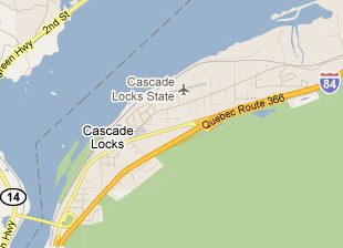
Quebec Route 366, according to Google runs from Atlantic City, New Jersey to Astoria, Oregon-aka U.S. Route 30. Here it is at the beginning and near the end.


The street view from Atlantic City


Why did this happen? I have no idea and nobody seems to have an answer on the google maps help forum.

I first discovered this issue when looking for something in the Exton-Downingtown suburbitopia.


Soon I discovered that they renamed the Benjamin Franklin Bridge.


Much of the legendary Lincoln Highway is now Quebec Route 366. This page from the Pittsburgh Tribune-Review even lists a restaurant in Ligonier, Pennsylvania as being on Quebec Route 366.

Here are more views of scenic Quebec 366 as it travels across the USA.

Over and around Fort Wayne, Indiana


On the edge of Cedar Rapids, Iowa


Heading into Cheyenne, Wyoming


Pocatello, Idaho out by the airport.


Cascade Locks, Oregon

Portland, the City of Roses.


I don't know why Google has been so slow to fix this but hopefully it won't be too soon. Otherwise this post won't be as fun. I hope traffic isn't too bad on your stretch of the 366.

Wednesday, December 29, 2010

Google Zeitgeist-the most popular searches of 2010

Google Zeitgeist reviews the most popular search terms of 2010. You can pick a country and see the most popular searches by month and the most searched personalities (some muppet named Justin Bieber tops most of the lists.) For the United States you can choose a city and see the most popular searches (university web mail servers are huge.)
Of course the best part is the interactive map.


You see how frequently some of the major stories of the year were queried by month with bar charts for each country. You can also play an animation for the entire year and compare up to three stories.

Also, you can choose a subject or person and get a map showing interest by state. Here is the Justin Bieber popularity map. Pardon the hideous plate carree (or something similar) projection. Happy New Year Justin-Virginia loves you!

Wednesday, December 8, 2010

States and Provinces Auto-Completed

The auto-correct feature on smart phones can be really annoying but if it didn't exist we wouldn't be able to waste our workday looking at Damn You Auto Correct!


Google has a slightly different feature called autocomplete based on web searches. Here is a map of the United States showing google's autocomplete suggestions - via Very Small Array.


Too bad the gratuitous topography makes it hard to read at this scale but if you click the map you'll get a readable version. There are at least five unfortunate states, that do not even contain google's autocorrect suggestion. See if you can figure them out.

Here's Canada, courtesy of the GIS User blog.

Wednesday, November 10, 2010

Nicaraguan "Invasion" caused by Google Maps - or maybe not.

Nicaragua invaded Costa Rica because of an error on Google Maps! At least that's the story being tossed around the internet in articles like this one and in Wired. Of course like many stories, the truth appears to be more complicated and less satirical. Ogle Earth has an excellent summary of the border dispute. Here are some basics:
  • The eastern part of the border between Nicaragua and Costa Rica is the San Juan River. 
  • The south bank (and sometimes east) of the river belongs to Costa Rica. The river belongs to Nicaragua but Costa Rica is allowed to use it for commerce.
  • Google maps incorrectly shows the border deviating from the river course giving a part of the Isla Calero to Nicaragua. Bing is basically correct although the alignment between the border and the river is poor.
  • In late October, Nicaraguan troops occupied a part of this land and began clearing the forest and dredging the river channel.
  • Costa Rica no longer has an official military to defend their land.
  • The official map that each country provided to the International Court of Justice both show the same border-along the river's main channel.
  • After the fact, the Nicaraguan government discovered the google error and used it to justify the troop incursion- from this article(translated.)
  • Nicaragua also uses historical changes in the course of the river channel to justify their claims

Here is a map of the area claimed by Nicaragua from Managua's La Prensa. The red line is claimed to have been the course of the river in 1897 when US President Grover Cleveland arbitrated a more detailed boundary (than the 1888 settlement) for this area.

However, the UN Settlement includes this map and contradicts Nicaragua's claim. The settlement clearly states that the boundary follows the main branch of the river and not the Taura Branch as claimed by Nicaragua.


Still, if you want to blame google maps go ahead - join the crowd!
************************************************************
UPDATE: Brandon T. sent me this video from newsy about the border dispute. Thanks!

Multisource political news, world news, and entertainment news analysis by Newsy.com

Thursday, June 3, 2010

Map of the Week-Google Conquers Space!

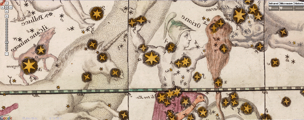
In addition to knowing everything about you Google now has the Earth, the Sky, the Moon and Mars - in map form. Like Google Maps, Google Sky gives you an interactive mosaic of the visible universe. The images come from various sources, details can be found on their about page.


The buttons on the upper right give you the option to see infrared and microwave views, as well as overlaying a "historical" map from 1792 drawn by Giovanni Maria Cassini. The view below covers the same area as the one above.


You can zoom, pan and click on things as well as selecting views, galaxies, planets and constellations from a gallery at the bottom of the page. Here is a view of the Crab Nebula.


In addition to the sky, you can also Google Moon and Google Mars.
Here is a view of the moon with imagery, charts and Apollo Landings overlaid.


Here is what the topographic chart option looks like.


Finally, here is an elevation image from Google Mars.

Wednesday, June 3, 2009

Japan's Google Earth Problem

Here's a story I missed while dedicating an entire month to bicycling:
The Japanese government and some equal rights groups are upset with Google for placing links to these gorgeous 18th and 19th Century woodblock maps of Tokyo (Edo) in Google Earth.*

c. 1850 Map of Edo or Tokyo


Why? Because they show the locations of Buraku villages. The Burakumin are a minority group who were “outcasts” under old Japanese caste system, dating from the early feudal shogun era. This system identified the Burakumin as “untouchable” due to their employment in death related or "impure" professions such as gravediggers, undertakers, executioners and leather workers. They lived in secluded hamlets or ghettos.
These prejudices survive and some fear that this information will promote discrimination in previously forgotten Buraku areas. Google has responded by having references to Buraku villages removed, however they may be reinstated as "historical documents."
For an excellent summary see this entry from the Geographicus Antique Map Blog.


*Google Earth has a feature where you can link to maps from the David Rumsey Map Collection. The Japanese maps are from a collaboration between Rumsey and the East Asian Library at the University of California, Berkeley.