Showing posts with label wtf?. Show all posts

Wednesday, June 1, 2011

Quebec's Longest Highway

Quebec Route 366, according to Wikipedia is "a secondary highway in the Outaouais region of Quebec. It runs from Route 301 near Creemorne in the Pontiac to Route 148 in the city of Gatineau."

 
Quebec Route 366, according to Google runs from Atlantic City, New Jersey to Astoria, Oregon-aka U.S. Route 30. Here it is at the beginning and near the end.


The street view from Atlantic City


Why did this happen? I have no idea and nobody seems to have an answer on the google maps help forum.

I first discovered this issue when looking for something in the Exton-Downingtown suburbitopia.


Soon I discovered that they renamed the Benjamin Franklin Bridge.


Much of the legendary Lincoln Highway is now Quebec Route 366. This page from the Pittsburgh Tribune-Review even lists a restaurant in Ligonier, Pennsylvania as being on Quebec Route 366.

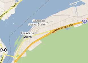
Here are more views of scenic Quebec 366 as it travels across the USA.

Over and around Fort Wayne, Indiana


On the edge of Cedar Rapids, Iowa


Heading into Cheyenne, Wyoming


Pocatello, Idaho out by the airport.


Cascade Locks, Oregon

Portland, the City of Roses.


I don't know why Google has been so slow to fix this but hopefully it won't be too soon. Otherwise this post won't be as fun. I hope traffic isn't too bad on your stretch of the 366.

Wednesday, March 11, 2009

Map of the Week - Lordy what's wrong with this picture?

Now showing through May 17th at the Austin Museum of Art: "Lordy Rodriguez: States of America". Rodriguez was born in the Philippines but grew up in the United States. He "reconfigures" maps that are in the words of artdaily.org "at once distinctly familiar and candidly absurd." For example, Wyoming:

More from the artdaily.org review:
"By choosing to draw maps, Rodriguez explores formal relationships and semi abstraction without worrying about the representation of depth. His firm shapes and bright, translucent colors decorate the surfaces of his maps with playful, captivating patterns. While maps often assume an unquestionable authority of accuracy and fact, Rodriguez dismantles conventional notions of locale and geography through intuitive associations and personal narratives. These vivid narratives conjure up the viewer’s own memories and perhaps compel one to ask whether the United States truly look like those that we used to envision."


Thursday, July 3, 2008

Map of the Week-Happy Birthday USA!

In honor of July 4th, I've been looking at Uncyclopedia, a mostly stupid but amusing Wikipedia farce, for some fun maps of the US. So in the spirit of dumb holiday fun here is how the rest of the world sees us:

And this is the world according to us (or US):


And just because I like this picture, here is what they consider a typical road sign you'd find on Interstate 4 in Florida.

Wednesday, October 10, 2007

Map of the Week #95 - The Inglehart Values Map

The Inglehart Values Map visualizes the strong correlation of values in different cultures. Countries are described using two dimensions; secular-rational vs. traditional values and self-expression vs survival values. Countries that are geographically or culturally close cluster in different areas on the chart. A more detailed description is available by clicking below.

Thursday, April 12, 2007

MOTW #72


This is a "map" of geographic knowledge compiled by Dr Andre Skupin at San Diego State University. I don't really understand it much but it's an interesting concept anyway. His own description:
"Visualization of the geographic knowledge domain based on more then 22,000 conference abstracts submitted to the Annual Meeting of the Association of American Geographers (1993-2002). Landscape features express the degree of topical focus, with elevated areas corresponding to more well-defined, topical regions and low-lying areas corresponding to a mingling of various topics. Dominant terms are used as labels for topical regions."