Wednesday, February 29, 2012

Super Commuting

A new report from NYU's Rudin Center for Transportation Policy and Management details the rise of the "super commuter" - someone who commutes from one metropolitan area to another. The report is summarized in an article in the Atlantic Cities. This map shows "non-local labor sheds" for major U. S. cities.

The stars are the commuting destinations while the graduated circles represent the home areas of commuters from outside the region. I like the gratuitous inclusion of Puerto Rico at the bottom right of these maps.

According to the study, these commuters tend to be younger people with modest incomes and may be making these commutes to take advantage of more affordable housing. Many of them probably don't need to show up in the office more than a couple of times a week. Two of the top super commutes are Houston to Dallas and Dallas to Houston. Sounds like a recipe for a house swap reality show.

I grabbed this image directly from the report as a typical detail of one of these areas - in this case Chicago.


 The darker reds represent larger percentage increases. While Detroit had the largest percentage increase, it is still coming from a much smaller number of actual commuters,. Cities such as Champaign and Saint Louis had higher absolute increases. I don't know why Milwaukee is so much smaller than the other cities when it is so close by - better job market there?

Friday, February 24, 2012

Spying on Those You Care About

My wife is flying through thunderstorms from Philadelphia to Fort Myers, Florida. I just got a free iPhone app called "Flight Aware" so I can see where she is. You can also see the thunderstorms moving out to sea.


I can also see what kind of air traffic she'll be up against in the area.


And take look at the airport area to see how much more traveling she needs to do from the airport. This is almost as cool as Passur's live airport monitors!


UPDATE - she made it! Thank you airline industry!

Wednesday, February 22, 2012

Akihabara-Japan's Electronics Market

My September, 2008 issue of Nipponia magazine features Akihabara. This district of Tokyo has become the world's largest collection of electronics stores as well as a lifestyle mecca for fans of manga, anime and video games.
The printed copy has a large centerfold map of the district-here's a copy from their web site.


The red and dark blue dots are electronic stores and parts stores. Orange are computers and peripherals. Pink dots are pop culture stores and light blue dots are places that sell mini cars, train sets and robots. The map also shows you where you can get canned bread, o-den ("chunks of food") and other delicacies.

The green dots are maid cafes. These are cafes where you can live out your video game fantasies (aka cosplay) by being served by maids who will refer to you as "My Lord and Master" or "Your Ladyship" and may cast spells or draw pictures in ketchup on your food. Most customers are male - big surprise!


Wednesday, February 15, 2012

The Pennsylvania Underground Railroad

To honor black history month, I went digging for maps. While the Underground Railroad is only a piece of that history, it has some of the most interesting map content. I came across this nice map of Underground Railroad sites around Kennett Square in Chester County, Pennsylvania. Quakers from the area were active in the abolitionist movement. The map is from the Kennett Square Underground Railroad Center.


A large print of the map is available here. Below is a detail:


I also found this schematic of the area from the website of Singing Wid a Sword in Ma Han  - a musical docudrama of the Underground Railroad in Pennsylvania playing in New York City.


For a complete picture of the Railroad's breadth, here is a map from Slavery in America.


Sunday, February 12, 2012

Map of Lima Peru

Look below to find yourself a map of Lima Peru for your reference.

Lima is the capital city as well as the biggest city in the South American country of Peru. And when I say it`s the biggest city, I mean it`s a massive city - the biggest city by far. It has a whopping population of over 7.6 million in the city proper, and 8.5 million in the metropolitan area. That is approximately a third of the population of the entire country. It is situated in the center of Peru, on a desert plain that overlooks the Pacific. Its metropolitan area extends to the coast and incorporates the seaport of Callao. It is the fifth most populous city in Latin America, after Mexico City, Sao Paulo, Buenos Aires, and Rio de Janeiro.

The city was founded by the Spanish in 1535, and became the capital of the Spanish Viceroyalty of Peru. Then, after Peru gained its independence, Lima became the capital of the new Republic of Peru.

Lima is a major destination for tourists, especially the UNESCO World Heritage Sites of Lima and Rimac - the historical districts of the city. Other attractions include the beautiful and extravagant colonial architecture such of the Monastery of San Francisco, the Catherdral, Covenant of Santo Domingo, the Palace of Torre Tagle, and the Plaza Mayor.

The climate of desert is pleasant and comfortable, despite its location in a so-called subtropical desert. The summers (ie. winter in the northern hemisphere) are warm and dry, while the winters (summer in the northern hemisphere) are mild with little variation between day and night temperatures. Winter daily lows are between 12 to 16 degrees, and daily highs are between 16 to 19 degrees. And I`m talking degrees celsius, so don`t panic, Americans!

Map of Greater Lima Peru
Central Lima Map in Peru
Map of Lima for tourists

Were the above map of Lima Peru downloadable images what you had in mind when you visited this page? I hope so. Leave a comment and let me know what you think.

Saturday, February 11, 2012

Map of Shenzen SEZ

Down below the article there will be a map of Shenzen China for you to make good use of.

Shenzen is a large city located in southern China in Guandong Privice. It is located just north of Hong Kong, just beyond the border of the Hong Kong Special Administrative Region. Shenzen itself is a SEZ (special economic zone) created to capitalize on its proximity to Hong Kong. These SEZs have more economic flexibility and more business friendly environments than mainland China as a whole.

Before the creation of the SEZ in 1979, Shenzen was a sleepy little village, but huge amounts of foreign investment as well as economically-incentivized migration, made this a boom town of monstrous proportions. Its population is now larger than Hong Kong`s with over 10 million people.

Basically the same as Hong Kong`s, Shenzen`s climate is subtropical, with hot humid summers and mild winters that are fairly dry.

map of Shenzen
map of Shenzen China
Tourist map of Shenzen SEZ China

Enjoy your visit to Shenzen, China and I hope you find the above map of Shenzen collection useful in navigating this gigantic new city.

Friday, February 10, 2012

Map of Buenos Aires, Argentina

Check out a map of Buenos Aires, Argentina down at the bottom of the destination profile article.

Buenos Aires, Argentina is the most populous city in the South American country of Argentina, as well as its capital city. After Sao Paulo, Brazil Buenos Aires is the second-largest metropolitan area in the continent of South America. It has a city population of 2.9 million, and a metro population of around 12.8 million.

Strangely, the city of Buenos Aires is not the capital of Buenos Aires province - in fact, it is not a part of the province at all. It is its own autonomous district which is governed independently.

Buenos Aires is located in the southern hemisphere, which means that January is the hottest month. Summers are hot while winters are mild and sometimes cool, especially at night and in the early morning. Downtown Buenos Aires, near the ocean, rarely experiences frost, though some of the inland suburbs do in fact see frost on occasion.

Buenos Aires map
Big map of Buenos Aires Argentina
Argentina Buenos Aires map

How was the Buenos Aires, Argentina map collection above? Hopefully it served the purposes that you needed. Have a look to see if we offer any other map collections that you are interested in.

Map of Guangzhou, Guangdong, China

Down below you can download a good map of Guangzhou, Guangdong, China.

Guangzhou is the third largest city in China, as well as the capital and most populous ity in Guangdong province. It lies only 120 km north of Hong Kong, and a slightly smaller distance from Shenzen. It was known historically as Canton, the origin of the name of the Cantonese language. The city`s population is a whopping 12.78 million.

The city shares a similar climate with Hong Kong and Shenzen, a humid subtropical climate with hot, wet, and humid summers and mild, dry winters. April through September bring the monsoon season, with high humidity and heavy rainfall occuring regularly.

The area around Guangzhou contains many highly populous cities which can be thought of as a single megacity with a population reaching as high as 40 million people. These cities include Shenzen, Dongguan, Foshan, Jiangmen, Zhongshan, and part of Huizhou.

Map Guangzhou
Guangzhou map of China Guangdong
Map of Guangzhou Guangdong China

I hope you found the above maps of Guangzhou useful and I hope they aid you in your preparation for a visit to this little-known but major metropolis.

Thursday, February 9, 2012

Map of Lisbon, Portugal

At the bottom below the article, there is a map of Lisbon Portugal or two for your commuting and travel info.

Lisbon is the largest city in the southwestern European nation of Portugal, as well as its capital city. The city population is 545,245, but the entire metro area`s population reaches as high as three million people - so Lisbon is a big bustling city. This is around 30% of Portugal`s population.

Lisbon is located further west than any other big city in Europe, being situated on the western part of the Iberian peninsula on the Atlantic Ocean, as well as the Tagus River.

It is not usually known as such, but Lisbon is actually one of the oldest cities in the world, older than Rome, London, and Paris.

As many cities in southern Europe do, Lisbon has a subtropical Mediterranean climate with mild wet winters and warm/hot dry summers. Average highs in summer are around 28 degrees celsius, and averageh highs in winter are around 15 degrees. Average lows in winter can be fairly chilly, around 8-10 degrees (though temperatures often dip lower than that range).

icon map ofLisbon Portugal
Map of Lisbon Portugal
Lisbon Map Europe

Judging by the large size and amount of detail in the above Lisbon maps, I hope you found one that you can make good use of.

Map of Tel Aviv

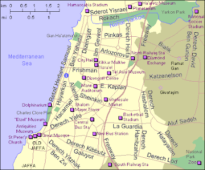
After the article about the city, you can choose a map of Tel Aviv, Israel for informational or travel purposes.

It is said that there are two Israels, and the focal point of one of those Israels is Jersualem. It is the religious and historical capital city where Orthodox Jews form a large part of the population and day-to-day life is more Jewish. Then of course there are the Arab neighbourhoods in the city, which are traditional and religious in their own way. The focal point of the other Israel is Tel Aviv, the modern, secular capital located on the Mediterranean Coast. It is a city of beaches, restaurants, nightlife, shopping, and other staples life for secular Israelis.

Tel Aviv itself is a small city of only 405,000, which is smaller than Jerusalem. But Jersualem`s metro area much smaller than Tel Aviv`s metro area of over 3.3 million. This area is called the Gush-Dan region, a sprawling cluster of modern suburbs radiating outwards from Tel Aviv. This metro area makes up nearly half of Israel`s population.

Tel Aviv is a modern city that was founded in 1909, adjacent to the town of Jaffa (Yafo in Hebrew) whose history extends back to Biblical times. Tel Aviv-Yafo is now a single municipality, uniting both ancient and modern into one city. Jaffa`s Old City, while nothing like the Old City of Jersualem, is a popular attraction and a beautiful escape from the bustle of central Tel Aviv.

Tel Aviv has a subtropical Mediterranean climate, with hot humid summers (and believe me when I say humid), and mild wet winters. Daytime highs in winter are reasonably warm, in the 15-20 degree range, but lows are typically in the 8-10 degree range, with temperatures sometimes dropping lower. Freezing temperatures are virtually unheard of and have only occurred a couple of times in recorded history. Though snow has been seen on various rare occasions in some of the inland suburbs of Tel Aviv. But those are rare occurrences, and anybody coming from a colder climate will find Tel Aviv`s winters pleasantly mild and comfortable.

Map of Tel Aviv Yafo
Israel Tel Aviv map
Tel Aviv road map

I hope the above Tel Aviv map files will be useful to you in your travels to the Israeli coastal plain.

Map of Zurich Switzerland

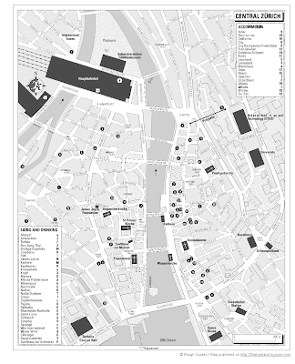
Down below you can find a map of Zurich Switzerland collection.

The first two maps are scans from a Rough Guide travel book. The first shows Zurich as a whole, and the second focuses in on Central Zurich.

Zurich is the most populous city in the federal state of Switzerland, as well as the capital of the Zurich canton. If you don`t know about Zurich, it is a federation of formerly independent countries, with each federal state being called a "canton". The various cantons have various official languages and cultural differences.

Zurich is not a massive city. It has a population of around 380,500 people. The metropolitan area as a whole has a much larger population of around 2 million, but it still has the feel of a small city.

The city`s climate features four distinct seaons, with moderately warm summers, cool to mild fall and spring, and cold winters. Average winter highs range from 3 to 8 degrees celsius, and average lows range from -5 to 0 degrees.

Zurich is a city of natural beauty and a place of outdoor activities and sports. Many people get around the city on bicycle, with bike lanes clearly labelled and marked for the benefit of cyclists.

Map of Zurich Switzerland
Central Zurich map
Tourist map of Zurich Switzerland

Wednesday, February 8, 2012

Map of Madrid, Spain

Look down below for a good map of Madrid, Spain. There`s a tourist map of Madrid, Madrid street map, and more.

Madrid is the capital city of Spain, as well as its most populous city with a population of 3.3 million in the city proper. There are over 6.2 million people if we include the whole metropolitan area. Its metro area is the third largest in the EU, after London and Paris.

It is located in central Spain, at a relatively high elevation which causes it to have relatively cold winters compared to other cities with Mediterranean climates. In the summers it is hot and dry, with temperatures over 30 degrees the norm. In the winter the daily highs are usually in the range of 9-12 degrees, with average lows ranging from 2 to 6 degrees. Note that I am talking about degrees celsius here, not the American farenheit system of measurement.

Madrid is a city of impressive historical and cultural attractions which attract over 6 million visitors a year. These include the Valley of the Fallen, Victory Arch, Royal Palace of Madrid, Palacio Real, the Real Basilica de San Francisco el Grande, and the lovely Church of Saint Anton’s.


Map of Madrid
Madrid tourist map
map of Madrid downtown area

Enjoy the map of Madrid Spain that you chose from the above mini-selection. Be sure to check out the other Spanish and European cities in our collections.

Unexploded Vacation

This week I am on vacation on the Puerto Rican island of Vieques, a former U. S. Navy bombing range. Thanks to the protests of the local residents we can now enjoy it without fear of an air raid. The beaches are excellent but be careful of unexploded ordnance.

Map of Tehran, Iran

At the bottom of this page you can find a good map of Tehran and its surrounding areas, as well as a good road map of Tehran. I hope they`re what you`re looking for!

Tehran is the capital city of Iran, as well as its largest city by far. It is also one of the largest cities in both the Middle East and South Asia, with a population of 8,429,807 in the city proper.

Tehran is in the Middle East, so maybe people imagine it as being in the middle of the desert surrounded by rolling sand dunes. But the Middle East is a place of variety, and Tehran is actually not in the desert. It is indeed hot in the summer, but is definitely cold in the winter with daily highs in the range of 7-10 degrees celsius, and daily lows often falling below 0 degrees. It is a city of many hills and varying elevations, and the higher elevated areas in the north part of town can be significantly colder than the lower lying areas. Spring and winters are mild, with most of the year`s precipitation occurring in those seasons.

Tehran is served mainly by Imam Khomeini airport, which lies a good 50 km outside of the city. The old international airport is still used for domestic flights and military use.

Map of Tehran in English and Farsi
map of Tehran, Iran

Map of Karachi Pakistan

If you need a good map of Karachi, Pakistan, then you can probably find one you like down below.

Karachi is the largest city in the South-Asian country of Pakistan. It is the country`s principal seaport, being located on the Indian Ocean coast in the south of Pakistan, and it is also the financial center of Pakistan. The government gets a huge proportion of its annual revenues from economic activity in Pakistan. 53.38%, to be exact.

It has a population of somewhere between 13 and 15 million in the city proper, and 18 million in the entire metropolitan area. This makes it one of the most populous cities on Earth, as well as the tenth most populous metro conurbation in the world.

Karachi has a hot arid climate with hot, humid summers, and mild and dry winters. "Mild" is a loosely used term here because the daily highs in the winter are typically in the mid to upper 20s. Daily lows in winter average in the range of 15 degrees, though cold nights do occasionally occur.

current Karachi map
City map of Karachi Pakistan
Road map of Karachi

I hope you found a useful map of Karachi, Pakistan up above, since a good map will help you in navigating such a gigantic metropolis.

Tuesday, February 7, 2012

Seoul Subway Map

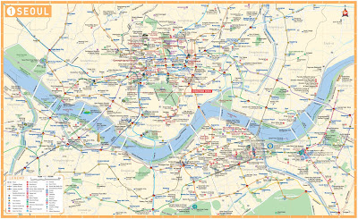
Below you can find a useful Seoul subway map to help you with your travels and commuting.

The Seoul subway system is one of the most heavily ridden rapid transit systems on earth. With 6.77 million riders per day, it is slightly lower in ridership than the Tokyo subway system. It consists of 16 lines in total, with a whopping 546 stations.

The system is like a maze, and just glancing at the Seoul Metro map can cause vertigo. But thank God that all station signs in Seoul are written not only in Korean but also in English. Chinese characters, called Hanja in Korean, are often displayed as well.

Here is a Seoul Metro map in English, useful for travelers and expats.

Seoul Metro Map English

Here`s another Seoul Subway map, showing the same information. But I like the design and layout of this one better. It`s easier to follow this map.

Seoul Subway map

Map of Seoul Korea

You can find a useful map of Seoul Korea down below.

Seoul is the largest city in the nation of Korea, as well as its capital city. It is a megacity on the scale of Tokyo or New York City, with a city population of over 10 million. Its metropolitan area has a population of over 25 million (which includes the nearby large city of Incheon, which shares Seoul`s international airport both in proximity and in name.

Seoul is located in the northern part of South Korea, and has 4 distinct seasons. The summers are hot and humid, with a rainy season in June and July (similar to Japan). Winters are cold and dry, with 28 days of snow per year on average. Averafe low temperatures reach -6 degrees celsius in January, with average highs only 1.5 degrees in the same month.

Here is a map of Seoul in English.

Seoul map English

This one is a map of Seoul labelled in Chinese characters.

Map of Seoul Chinese Characters

This one is a map of central Seoul.

Map of Seoul downtown

Map of Beijing

Please check down below for a good map of Beijing to enjoy using on your trip to Beijing.

Beijing is the capital city of China as well as a huge metropolis with a massive population of 19,612,368. That makes it the second largest city in the country, with the first being Shanghai. But unlike Shanghai which serves primarily as a financial and commercial center, Beijing is the historical, political, and cultural center.

The name of the city means "Northern Capital", which clearly explains the geographic location of Beijing, situated in the northern part of China, close to inner Mongolia. The climate of Beijing features hot and humid summers, as well as cold, windy, dry winters with daytime highs sometimes below freezing. A

Big Beijing map
Beijing Road Map
Tourist map of Beijing

Thanks for checking this page out and I hope you grabbed yourself a good map of Beijing, China.

Monday, February 6, 2012

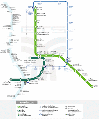
Bangkok BTS Map

Here you can find a Bangkok BTS map for your reference and trip preparation.

What is the Bangkok BTS system? It is the Skytrain system, meaning urban rapid transit system elevated above ground. BTS stands for Bangkok Transit System. There are only 2 lines and a total of 32 stations. There is the Sukhumvit line, and the Shilom line. They together have a daily ridership of 600,000 people.

The system, when it was originally being planned, was referred to as "Skytrain" because it was based on the Vancouver Skytrain system.

Here is a BTS Bangkok Map, which shows connection points with the Bangkok MRT system.

Bangkok BTS map

Here is another Bangkok Skytrain map, this one without MRT connections.

Bangkok Skytrain map