Showing posts with label Philippines Maps. Show all posts

Saturday, July 10, 2010

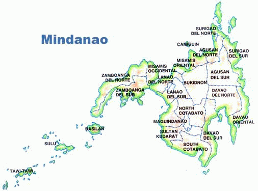
Maps of Mindanao Island, Philippines

Mindanao is a major island in Philippines and one of the three adiministrative regions of the country (the other two being Luzon and the Visayas). In terms of size it is second only to Luzon island. "The land of promise", as Mindanao is sometimes called, has an estimated population of 21,582,540, making it the second most populous island (compared to Luzon's approximately 45 million inhabitants and the Visayas' approximately 17 million.

The exact size of Mindanao island is 61,077 square kilometers, or 23,582 square miles.

Maps of Mindanao island in Philippines
Mindanao island map
Map of Mindanao Philippines island

Mindanao is a great place to visit if you keep aware of the political reality of the island. I hope the above maps of Mindanao assist you in your research and planning!

Thursday, September 4, 2008

Philippines City Maps

Philippines is a very populous country, with a significant portion of the population residing in the urban centers. Here I've gathered some important Philippines City Maps for your use and convenience.

The largest city in Philippines is Quezon City with a population of 2,679,450, which is actually a part of metropolitan Manila. So effectively they, along with other cities in the area, form one urban area. I think of it as part of Manila.

Manila City itself has a population of 1,660,714 and is incredibly densely populated, with a population density of 43,079 people per square kilometer.


For city maps of Manila, please see this detailed street map of Manila.

This is Cebu City, with a population of 798,809.

Philippines City maps of Cebu city, a gorgeous coastal town.

Next is Bacolod city, with a population of 499,497.

Bacolod Philippines City maps for southeast asian travellers.

Here is an overview of the area around Davao city.

Philippines city maps of Davao urban area in beautiful lush southeast asia troical area.

Here's a detailed map of central Davao City, with a population of 1,363,337.

Philippines city maps of downtown Davao City.

I hope you found these Philippines City Maps useful. Check back often for more useful maps from Asia and around the world!
Saturday, August 30, 2008

Detailed Street Map Of Manila

Metro Manila is a massive metrolpolis consisting of Manila City, the national capital; Quezon City, the nation's most populous city and former capital; and 14 other cities and municipalities. Metro Manila has a population of over 11 million. If the nearby suburbs in neighbouring provinces are included, then the greater Metro Manila conurbation has around 22 million people.

This extensive sprawl is well connected by its road network.

First for perspective, here's a simple printable map of Metro Manila with no roads shown.

Simple map of Metro Manila no road.

Here's a detailed road map of Metro Manila, or the National Capital Region (NCR) as it's also known.

Detailed road map of Metro Manila, showing the capital and its suburbs.

Another basic road map of Metro Manila.

A detailed street map of Manila City itself.

Detailed Street Map of Manila in English and Korean.

Another detailed street man of Manila and its suburbs.

Detailed street map of Manila City

Manila City by itself is not so big in size. But it is densely populated.

A detailed street map of Manila and its surrounding suburbs.

I hope you found this detailed street map of Manila City and road map of Metro Manila useful. I'm very interested in Southeast Asia, so I plan to be uploading more maps from the Philippines and elsewhere very soon. Be sure to check back for updates!

City Map Philippines Luzon

If you're looking for a city map Philippines Luzon

Luzon is the largest island in the Philippines, and its most politically and economically important. The capital city of Manila is located on Luzon, as is Quezon City - the most populous city in the Philippines and an integral part of Metro Manila.

As the world's 15th largest island, Luzon's total area is 104,688 square kilometers. It is the 5th most populous island in the world, with a population of 39,500,000.


Major city map Philippines Luzon island.

Main city map Philippines Luzon Island.

Capital region city map Philippines Luzon island.

I hope this made use of these city map. Philippines' Luzon island is an exciting place to visit, and I hope you will have a chance to visit too. I add new map themes all the time, so be sure to bookmark or subscribe and check back often for new map uploads. See you next time!