Wednesday, April 29, 2009

Re-Imagining Cleveland

Cleveland, like many northeastern US cities, has been experiencing a steady population decline for decades. The estimated 2007 population is less than half of its 1950 population. An excellent article from the Planning Commissioners Journal highlights some interesting ideas the city's planners have for some of the empty spaces. These ideas include farms, community gardens, and restored wetlands among new commercial and residential districts. Kent State University's Cleveland Urban Design Collaborative (CUDC) has a great report entitled "Re-Imagining a More Sustainable Cleveland" that details many of these ideas. The report can be downloaded from their site, however it is a large file. There are lots of maps that if overlaid can be used to determine the best sites for the above uses. For example, here are maps of foreclosures and vacant land.


The map below on the left shows population loss in blue while the map on the right is the county's proposed"Greenprint."


The report has a nice overlay map showing different soil types to distinguish areas that are more suited to agriculture vs. areas that are better for wetland restoration. These are overlaid on top of existing parks and vacant areas (in dark brown).


Other useful overlays for these purposes are brownfields, estimated population trends and impervious surfaces. Some of these maps are from the Green City Blue Lake website while others are from the CUDC report. Below is a design concept from the report for land in areas around stream headwaters.

Population loss can be a tough pill for a city to swallow but if these ideas are carried out it could turn Cleveland into a model of a desirable urban community.

Wednesday, April 22, 2009

Unfinishtstan-A Kitchen Wall in Edinburgh

Collins Geo, formerly Bartholomew (whose World Atlas I featured in a previous post), has a map blog. On that blog there's a "Map of the Month." They sent me this month's map, a rendering of imaginary countries on a kitchen wall. The map's boundaries and features have been determined by an uneven plastering job. Click the map for the story, map details, pinxits, Badley Smooved Mountains and an enlarged image of this "wall map."

Thursday, April 16, 2009

Map of the Week-Patriot's Day Edition

Monday is Patriot's Day here in Massachusetts. We commemorate the first revolutionary war battles by taking a day off from work and re-enacting these battles. We also have related activities like a morning Red Sox game,  a marathon, drinking beer out of paper bags on the T and bragging about our "wicked awesome" sports teams.  Here is a map of the activities of April 19th, 1775 - some of it happened right down the street from me.  

Thanks to the Department of Military Science at Worcester Polytechnic Institute for the map. Their timeline of events (and this map) can be found here

Wednesday, April 8, 2009

World Map of Fault Lines

Fault lines are the lines that mark a boundary between two tectonic plates of the Earth's crust. Earthquakes usually take places along these fault lines, as two plates move in different directions and built up pressure is released as the plates slip suddenly.

Why do tectonic plates move like that? Well, the plates are part of the Earth's crust, which sits on top of the Earth's mantle which is semi-molten. Since the mantle is not as hard as the crust, the crust "floats" so to speak, or slips/slides.

One fault line well known to North Americans is the San Andreas fault, which runs up the westcoast of the USA and was the location of the San Francisco earthquake.

Below you can find a world map of fault lines that may help you with your reference.

Map of the Week - Paris circa 1900

My wife gave me a "Vintage Maps" 2009 calendar as a Chanukah gift. This is the April map. Speaking in highly technical cartographic terms, I love the cool monuments as well as the details of woods, parks, forts and city walls. I stare at this map way too much at work and don't get other things done.
It is odd that no map credits are given in this calendar. There is just a title; "Paris Circa 1900". I usually like to have a link or give credit for the maps I post but in this case I must defer to the calendar's publisher Cavallini & Co.


Here is a detail of part of Central Paris for your viewing pleasure.

Map Of Hong Kong Islands

Hong Kong is a special administrative region of China, and a former territory of the United Kingdom. Many think of Hong Kong as a city, and indeed Hong Kong is a busy and vibrant urban center. But Hong Kong is an area comprising 1,108 square km (428 square miles) of land, including some land connected to the mainland of China, as well as a number of islands.

Hong Kong is broken down into 18 administrative districts, in three main areas. Those main areas are Hong Kong Island, Kowloon, and the New Territories. For all intents and purposes, Hong Kong Island and Kowloon comprise the city we know as Hong Kong, while the New Territories comprise the outlying areas.

Hong Kong has exactly 236 islands. The major ones are Hong Kong Island and Lantau Island. Lamma Island is also an important residential island that can be accessed by ferry from Hong Kong Island.

Hong Kong Islands map
Map of Hong Kong Islands
Hong Kong maps of islands and mainland
Hong Kong peninsula and islands

I hope you found the above map of Hong Kong Islands useful. Hong Kong is a beautiful and dynamic city, so I hope you visit soon!

Map of Santiago, Chile

Santiago is the capital of Chile, South America. With a population of 5,278,044 it is the largest city in Chile, and also has the largest urban area with 7,003,122 people.

Santiago City lies inside the Santiago Basin, a fertile plain surrounded by mountains with the Andes to the east, and the Chilean Coastal Range to the west. Extensions of the Andes also lie to the north and south, making the city surrounded almost entirely by mountains.

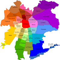
Greater Santiago contains 37 municipalities seen in the multicolored map below.

Below you can find a map of Santiago, Chile for download.

Map of santiago, chile neighborhoods
Map of Santiago, capital of Chile
Map of Chile Santiago
I hope you found the above map of Santiago, Chile neighborhoods useful. Be sure to check out our other maps of South America. See you next time!

Thursday, April 2, 2009

Brazil Curitiba Map

Curitiba is the capital of the state of Parana in Brazil. It is a large city with 1.8 million people, making it the 7th largest city in Brazil and the largest in Southern Brazil. The metropolitan area totals over 3.5 million people.

The city is located at 932 meters above sea level, making it relatively cool compared to other major cities in Brazil. Its climate is subtropical, with mild, wet winters and warm summers. But summer weather is not blistering hot. The highest temperature ever recoreded in the city is 35.6 degrees celsius, or 96.1 farenheight, and the summer average is around 21 degrees. The winter average is around 13 degrees. Winter nights and mornings can be cool and even cold. Snow has fallen a few times this century but not often.

Moreso than many other major cities in Brazil, Curitiba has a large majority of Brazilians of European descent. After the city was originally conquered by Portugese colonists, European immigrants from other countries including Germany, Ukraine, and Poland.

Here you can find a Brazil Curitiba map for your reference and information.

Road map of Curitiba Brazil

Brazil Curitiba city map

Brazil Curitiba map of city administrative regions

I hope these Curitiba, Brazil maps were useful. Be sure to check out other map collections and destination profiles.

Physical Map Of Brazil

Brazil is the largest country in South America and fifth largest country in the world. In fact, it occupies nearly half of the continent of South America, in total 8,514,877 km2 (3,287,597 sq miles). It borders Uruguay to the south, Argentina and Paraguay to the southwest, Bolivia and Peru to the west, Columbia to the northwest, and to the north lie Venezuela, Suriname, Guyana, and French Guiana.

It is so large that it spans three time zones. Its landscapes include mountain ranges, plains, highlands, hills, and scrublands. Our image of Brazil usually consists of Rio di Janeiro's beaches and the Amazon Basin, but in fact much of Brazil lies at 200-800 meters above sea level. Some areas of Brazil have an equatorial climate, others a highland tropical climate, others a temperate climate with coniferous forests, semiarad desert climates (in the northeast).

The largest city in Brazil is Sao Paulo with an impressive 11,150,249 people. Rio de Janeiro is second with 7,145,472 people.

There are 26 states plus one federal district of Brazil.

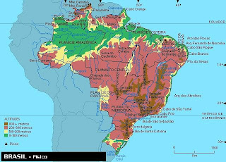
Below you can choose a physical map of Brazil.


Brazil physical map showing landscape


Map of elevations in Brazil


Physical satellite map of Brasilia


Map of vegetation in Brazil


In addition to the above physical maps here is a political map of Brazil as well.

Political map of Brazil and its cities and provinces


I hope that up above you were able to find a good map of Brazil South America. I hope you have a chance to check out our other maps and geographic profiles.

Physical Map of Venezuela

Venezuela is a beautiful country in the northern part of South America on the Caribbean Sea. It is bordered to the east by Guyana, to the west by Colombia, to the south by Brazil. Various Caribbean islands also lie near the Venezuelan Coast, like Trinidad and Tobago, Barbados, Aruba, and others. Venezuela's coast and Caribbean islands are popular high class resort areas.

Venezuela is 916,445 square km in size, and lies just north of the equator. It has a population of 28,200,000. The capital city is Caracas.

Venezuela has a variety of landscapes and climates. It has a tropical Caribbean coast and islands, the Andes Mountains with a cooler climate, the plains
that are full of wildlife, and tropical rainforests of the Amazon Basin and Orinoco Basin.

For more facts about Venezuela, have a look at my other site South America Travel Tips.

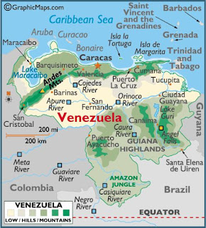
Below you can find a physical map of Venezuela.

Geographic maps of Venezuela


Detailed map of Venezuela


Detailed Venezuela physical map


I hope you found a detailed map of Venezuela up above that is suitable for you. Good luck on your travels in South America!

Wednesday, April 1, 2009

Map of the Week - Fargo Flood Wiki

With record flooding ongoing, The Forum of Fargo-Moorhead has set up a "wiki" map for flood information. Anyone with minimal map skills can edit it but frivolous postings will be removed. Good idea but cartographically it's a bit problematic when the editor can choose any color or symbol they like for their posts.

I think the original idea was maybe for shelters to be white, animal shelters green, drainage problems blue, web cams light green and closures in red. However, without a legend or guidelines for posting it gets a bit muddy. Also, the numbers are confusing - click a 3 and you get 3 points. Why not just show them all?

Despite those little flaws it's still a nice, useful tool for the area.

This map to the left, also from the Forum shows all the mandatory evacuation areas - some of them are shown in pink on the wiki.

Fargo's logo seems a bit ironic at the moment but best of luck to the area residents - I hope the worst is over.