Showing posts with label california. Show all posts

Thursday, March 29, 2012

Random Thursday-Maps You Probably Won't Use Today

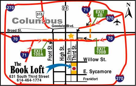
Have I mentioned that I don't really care for google (or bing or yahoo) maps? Sure they serve certain purposes very well and I even use them at work when they fit the bill. However, when directing me to your business I prefer a customized map. Here are some examples.

A map to the Kipu Ranch on Kauai where you can enjoy scenic beauty by ramming through it on an ATV.
Directions to Camp del Oro in Nevada City, California. You will probably get lost.


Raffles, an Asian restaurant in Nagoya, Japan. An Asian restaurant in Japan? What an idea!


The Book Loft of German Village - Columbus, Ohio. Absolutely not to scale but emphasizing the important details - and you can't do that in google!


Pasquia Regional Park in Saskatchewan- looks like it was drawn by a kid with cartographic skills.


A very red map of the locations of the Big R Stores in the Northwestern US. I love how the topography ends at the Idaho border!

Here's a map to The Strand - a development in Datarang Sunway, Malaysia. I got the image from Three Meals of Goodness, a Malaysian dining blog. I like the exaggerated earth curvature, and the Ikea.


Wednesday, January 5, 2011

Paradise Deserves a Better Fate

"Paradise in Panorama" is a giant relief map of California built in the early 1920's by a team of sculptors, engineers and geographers. Scientific American called it the largest map in the world when it was unveiled in 1924. The map is made of plaster, wire, paint, and "bits of rock and sand", is "as long as two football fields" and weighs about 70 tons. It showed California before the age of freeways, suburbs and major bridges.


A somewhat mysterious article appeared in the San Francisco Chronicle in October saying that the map has "turned up at an undisclosed location on the city's waterfront" without describing how or why. The article details a bit of its history. The map was on display for many years at the San Francisco Ferry Building, the country's busiest transit terminal at the time, before being damaged in that building's renovation project in the 1950's. It was then cut into sections and put in storage. The city offered the map for $1 for anyone willing to restore and display it but found no takers because of the map's size and the expense of moving it. Various schemes have been devised to redisplay the map but it remains in storage with an uncertain future.

Wednesday, July 28, 2010

Map of the Week-California Girls

This may be old news to some of you web surfers but I just discovered GraphJam. They have mapped and graphed many songs including "California Girls" by the Beach Boys.


Wednesday, April 14, 2010

Bizarre Map Challenge-Vote Soon!

The Department of Geography at San Diego State University is hosting the Bizarre Map Challenge. This challenge is open to high school and college students. Bizarre refers to "maps that are strikingly out of the ordinary." The top 10 finalists were selected this week and the 1st, 2nd and 3rd prizes will be announced April 27th. Subject matter includes personal ads, Thai formation skydiving records, French North American settlement patterns, staycation destinations and opinions about health care. Some of these maps are large files and can be slow to download. I made lower resolution images of some of my favorites.

Here is a map of California where the spacing and color of the county names is used to reflect physical geography. Letter spacing is tighter in the mountainous areas to give the illusion of topography.


Next is the "earth in reverse" - a map that uses a reverse color scheme, making the highest mountains look like the deepest parts of the ocean and vice versa. The map is also flipped so that south is up and west is to the right.


Finally, a map showing the locations of missed connections in Burlington Vermont from the I-Spy feature that appears in the personal ads of the Seven Days weekly.

Wednesday, March 24, 2010

Map of the Week-Replumbing California

The April issue of National Geographic is devoted to water, specifically the growing scarcity of fresh water. Articles cover ways to acquire, conserve and protect fresh water, our changing climate and conflicts over water, from the local to the international level. There are various maps, including a fold out worldwide "mapping of every river system." Online content includes this interactive map of California's water system. The online map is synchronized to a legend that shows the length and volume of the man-made water conduits that bring water west and south toward the Central Valley and large cities.

The article discusses the need to reduce the state's reliance on the Sacramento-San Joaquin Delta as a fresh water supply given that area's potential for salt water contamination and earthquakes. Without significant new conservation measures and better ways to transport water, the cities and farms of California will revert to the arid landscape that it was before these water projects were built.

Wednesday, September 16, 2009

Map of the Week-Tasty Wine Maps

I don't know much about wine. My keen sense of taste tells me that some wines are "better" than others. I do know that my local liquor store is decorated with some nice, colorful maps including this one.

This map is huge and takes a long time to download so I only show a section of it above. It is available online here (click the "Quality Wines map" link) if you want to wait for it. The store also has nice regional maps of France, but I could not find those online. However, I did find lots of other maps. Here is a nice general map of France for people like me who only know the most basic distinctions.


Those with a keener palette may want to dig into a detailed region such as the Loire.

If you're planning some wine tourism you might want a detailed map like the one below of Madera, California. I mainly included this map because it is, in my cartographic opinion, cute. You might get lost if you actually try to use this map as its accuracy seems to get lost in all the cuteness.

L'Chaim!

Friday, February 29, 2008

Map of the Week 114-Happy Leap Day!

You've been given an extra day on the calendar (why does it have to be in February?) so what crazy thing are you going to do with it? Four years ago you could have romped through the streets of Berkeley pelting chain stores and banks with styrofoam bricks and spilling coffee grounds outside of Starbucks. Here is the map from their 2004 poster showing the locations of all the chain stores-written sideways upside diagonal for your reading pleasure. I assume that none of these stores are still in business given their actions last leap day.

Thursday, October 25, 2007

Map of the Week #97 - California Burning

The US Forest Service has a web site that monitors major fires. Usually they are spread throughout the country but this week it's all happening in southern California. You can click on the dots on the map and get a status report for any fire. You can also link from this site to Google Earth and get a close up view of all the fire activity going on throughout North America. The image to the right from Google Earth shows the current fire activity in southern California.

Friday, September 14, 2007

MOTW #91 - Lake Tahoe Fire Risks

The Sacramento Bee had an article this past summer with a nice map illustrating how much building is going on in high risk areas for forest fires. The red are areas of high fire risk and the black dots represent building permit locations.

Thursday, May 10, 2007

MOTW #74


The California Coastal Project was a project where a pilot and photographer flew over the entire coastline of California taking aerial pictures every few hundred feet (except for Vandenberg Air Force Base which was off limits). They took GPS readings for each picture so you can click anywhere on the map and get the photograph for that location. Barbara Streisand unsuccessfully sued them for violating her privacy by photographing her Malibu estate. You can access details of the suit at this site if you really care.

Thursday, September 7, 2006

MOTW #43

This one's almost as cool as the LA Airport Monitor. Watch boats travel around the San Francisco Bay, get information about each boat, its destination and ETA. Give the boats a minute or two to load and then let them do their stuff!

Thursday, May 18, 2006

MOTW #30

This is a ridiculously clever map showing an index of happiness in LA using 4 separate variables, each showing a facial trait representing differing levels of stress or racial makeup. These are Chernoff Faces, a visualization technique created by mathematician Herman Chernoff. The map was created in 1971 by Cal State geography professor Eugene Turner for the Los Angeles Community Analysis Bureau.

Thursday, May 4, 2006

MOTW #28

Another cool java application. Watch planes take off and land at LAX. I can sit and watch this for hours!
UPDATE: It appears that LAX no longer participates with Passur and some of the other airports don't seem to be loading anything. The image above now links to Newark International instead where there is still some action to watch. If nothing's happening in Newark you can try some of their other airports.