Showing posts with label music. Show all posts

Wednesday, September 14, 2011

Map of the Week Miscellany for September, 2011

There's a lot going on this week and if I only didn't have to work I could devote more time to these posts and make them more meaningful but be careful what you wish for. Anyway here are a few interesting items I've found this week:

An Army Corps of Engineers map of the flood control structures in Wilkes Barre, Pennsylvania.


 The manual this map appears in describes how the levees in Wilkes Barre and across the river in Kingston can form a bottleneck and make flooding worse for communities downstream. In 1972 these walls were too short to contain the flow from Tropical Storm Agnes and the city was flooded. The water stored from this flooding helped spare downstream places like Sunbury. Since then the levees have been raised, partially sparing Wilkes Barre from this weekend's floods (though water did get in by seeping under the levees.)

This sent more water to downstream places like Bloomsburg, where record setting flooding occurred.


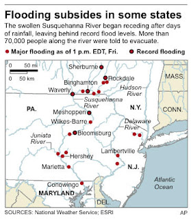
Below is a map from the AP showing the some of the worst hit places.
Daniel Huffman's wonderful river schematic map shows how these places interconnect.


***********************************
Other Miscellaneous Notes:
***********************************
Tomorrow night (September 15th) David Byrne will squish an inflatable globe under the High Line in New York City. It will be there until October 1st. To sort of quote one of his songs "this was a parking lot, now it's all covered in globe." More information is available from New York Magazine.


************************************
From LA Taco ("Celebrating the taco lifestyle in Los Angeles") comes this chart showing the population growth of the largest cities in the USA. 


Wednesday, May 4, 2011

Map of the Week-Mexico City's Subway Station Icons

When Mexico City designed it's subway system in the 1960's there was widespread illiteracy (not so anymore.) They came up with a solution of visual signs such as colors and icons. Each station has a unique logo or icon based on local points of reference, history, nature, etc.


For example the Pino Suarez station icon depicts an Aztec pyramid that was discovered during the construction of the station.

Salto del Agua shows a local fountain and Merced shows a box of apples because it's located adjacent to one of the largest outdoor markets in the city. The stories behind most of these icons can be found by clicking the station name from this wikipedia page.


The image above is a detail from this image from Wikipedia.


I discovered these icons when I was working on my Maps on Album Covers project. One of my favorite "Rock en Espanol" bands Cafe Tacvba (not a typo) put a fake subway diagram with fake icons on their Cuatro Caminos album. The album is named for a real subway station, but the others on this map appear to be whimsical creations.


Here is the real area around Cuatro Caminos - the geodesic dome is a former bullfighting arena.


Wednesday, April 13, 2011

Maps on Album Covers-Reader Suggestions

My recent "Maps on Album Covers" post was as incomplete as my music collection. Fortunately you folks stepped up and gave me some great suggestions. Here they are:

Hell's Ditch - The Pogues


Wisconsin by the Crucifucks


The Ambient series by Brian Eno is all kinds of mappy.


Coming Home by Maggie Bjorklund


No Borders Here - Jane Siberry, although the version I accidentally downloaded from her site has a different cover.


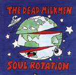
More globe than map but here's Soul Rotation by the vastly underappreciated Dead Milkmen.


This is not the front cover but apparently XTC's Colin Moulding has some nice cartographic skills. This is from Go 2.


The back cover of More Songs about Buildings and Food by Talking Heads. I'm not sure what this map is showing.

Thursday, March 24, 2011

Maps on Album Covers

I thought it would be a good idea to spotlight album covers featuring maps but it turns out that there are fewer than I expected. I had to dig in some obscure places to find the ones below. Not having an exhaustive music collection I may have missed something obvious or notable. Let me know and I'll add it to the list.

I'll start with one of my personal favorite covers. Nile Rodgers of the disco/funk band Chic came out with a solo album titled "Adventures in the Land of the Good Groove" with a cover featuring lower Manhattan with faux latin place names like "Uptownicus" and "Nova Joysey."


Probably the best known album on this list is Chicago XI-Baby what a big surprise!


Martha and the Muffins went with the topographic Toronto look.


Early American folk music specialists Tasker's Chance used this historic map of part of Maryland.


Representing the world of experimental classical music is the Chicago Sound Map.


Hardcore metal band Slayer's "World Painted Blood" has a collector's edition with four different covers that when put together form a world illustrated with skulls and bones.


 This is more of a globe than a map but I've always been partial to Yes so I had to include "Fragile."


Canadian popsters Barenaked Ladies used an oddly styled Michigan for a live album with the somewhat clever title "Talk to the Hand."

Two Philadelphia area bands previously covered here have some good map artwork. The Strapping Fieldhands map showing sightings of the New Jersey Devil and Slo-Mo's map of the Northern Liberties neighborhood.


Finally, a 4 CD compilation called "Left of the Dial: Dispatched from the '80s Underground" used some map mashups for their covers. Don't try to use the map below for wayfinding!


UPDATE: for more good stuff see the follow up post.

Wednesday, July 28, 2010

Map of the Week-California Girls

This may be old news to some of you web surfers but I just discovered GraphJam. They have mapped and graphed many songs including "California Girls" by the Beach Boys.


Wednesday, December 16, 2009

Bruce, Bruce and Tom-A Musical Journey

I've always been interested in the geography of musicians-where they come from, where they get discovered, and where they choose to reside when success allows them that choice. I've found a few nice musician maps over the last couple of years. These three artists were chosen because someone made maps for them, more than for any personal preference.

Bruce Cockburn was born and raised near Ottawa but has spent most of his musical career in Toronto. He currently resides near Kingston, Ontario according to his web site. Here is a clickable map of his life in Toronto:


If you prefer the other Bruce, here is a map of  Springsteen's New Jersey titled "Bruceville." Bruce Springsteen is that rare musician who's never needed to stray too far from home and has always remained true to the Garden State.

This map is more fanciful than accurate. The only places that really seem to be located correctly are the Boardwalk, Highway 9 and his father's house. Little Eden is Millville? "The River" is the Delaware? "Tenth Avenue Freeze Out" is about Tom's River? * I have my doubts about these things. Thanks to Strange Maps for this.                                                        * After consulting Wikipedia, the undisputed source of all knowledge, it turns out the "Tenth Avenue Freeze Out" may actually refer to 10th Avenue in Belmar. If true then the map is close.

Shortly before his Super Bowl XLII appearance, LA Weekly published this map  of Tom Petty's Los Angeles by illustrator Scott Gursky. Although a native of Florida, Petty moved to LA at the beginning of his career and has remained in the area ever since. The article details each place on the map.


Wednesday, October 14, 2009

It was 45 years ago today (last month)

At a yard sale in Pennsylvania we found a nice collection of vintage records and teen magazines from the 1960's. The sellers were big Beatles fans who saw them on tour and collected magazines that featured the band.

I picked up the October/November 1964 issue of "teen talk" for 50 cents. The original newsstand price was 35 cents. Issued on the eve of the first major U.S. Beatles tour*, there were lots of articles about the Fab Four and other British Invasion bands. Also included was a map of the tour.


* This magazine probably hit the stores well before October 1964 - the tour dates (August-September 1964) are mentioned in the future tense.

Thursday, August 6, 2009

Map of the Week-The New Jersey Devil

The Strapping Fieldhands were a Philadelphia based low-fi folk rock multi-instrumental band from the 1990s. They were like a weird pre-Decembrists band with a love of history, mythology and, of course, maps. They had a reputation for putting on a great live show (supposedly they stole the show when they opened for Guided by Voices) despite barely knowing how to play their instruments. Recording was not their strong point so what you often get is very good songs buried under a slushy, distorted mix.


I dug out their extended single "In the Pineys" yesterday for a long car trip. The cover features a nice map showing sightings of the New Jersey Devil. This beast stalks the Pine Barrens region of southern New Jersey (aka "the Pineys" to us urban snobs.) 100 years ago the devil returned after a long hiatus and terrorized the region. There were thousands of sightings within one week in January, 1909. With a quick web search I was able to locate the single's cover map.

The map, credited to Rosemary Ellen Guiley has some nice details, including a drawing of the beast itself and it highlights the many 1909 sightings. It also distorts New Jersey to emphasize the southern half of the state, while squeezing Somerville and New Brunswick far to the north. The Unexplained America page that includes the map has a good history of the legend as does the Devil Hunters page.

Nowadays sightings are few and the New Jersey Devil mainly conjures up images of a remarkably boring hockey team. For a hokey hockey take on the Devil's recent activity see the New Jersey Devils mascot page.

Thursday, July 9, 2009

Map of the Week-The Music Underground

A few years ago music writer Dorian Lynskey created this map for the Guardian, charting the history of recent western music along Harry Beck's famous London Underground map. Each line represents a musical genre. The more eclectic artists are at the intersections. The Circle Line represents Pop music because it intersects all the other genres.
Of course, it is not possible to do this without leaving out important artists or placing others in debatable locations. In the words of the author: "Pedants, of course, will find flaws. Musical influences are so labyrinthine that any simple equation will be imperfect." Still I can't help but wonder what Wilco has to do with Electronica and Dance or why the late King of Pop Michael Jackson is only on the Soul line.

Some of the article's comments are amusing too such as this one: "The most stereotypically self-indulgent Guardian wank I can think of, bordering on self parody. Smug, London obsessed (and I live in London) nonsense. It's got nothing to do with anything! There's people like, dying and stuff. And where are the Arctic Monkeys, anyway...?"

The full map at low resolution is below. For a detailed .pdf version link to the article from the thumbnail above.

Wednesday, February 25, 2009

Map of the Week - Heavy Metal Cartogram

DJ Yuletide from Melting Point Radio (WRMC-Middlebury College) presents this heavy metal cartogram. It is based on the number of bands registered on Encyclopedia Metallum. While obviously the bigger countries have more bands, the per capita metal leader was Finland with 2300 bands. Bands like Diarrhea Vomit and Life is My Enemy.


Questions arise such as:
Why is so much of the area of the USA taken up by Alaska? -
Do they really have more bands there than the rest of the country
or is it the "mediocre" Mapresso cartogram applet?
Does Greenland represent Denmark or Greenland?
Are all Europeans metal crazed freaks?
What are those 3 islands floating down near Antarctica? -
Or are they just there to look creepy?

Thursday, March 20, 2008

Schmap of the Week

Schmap is a Widget you can add to your website to post info about your team, band, city, or other interests. Better to show then tell.


Below you can see the latest exploits of my favorite pathetic hockey team - the Flyers. Click a puck and see how they did in that location - you can also look at the arena - this works better in baseball when you're not looking at roofs. If you don't like them, which you probably don't, you can change the team or even the sport by clicking the buttons up top. Above, for a more international perspective is everyone's favorite French league team Paris St Germain.


You can also put up a city tourist guide - I picked Baltimore in honor of the Baltimore Festival of Maps.


Or you can follow your favorite musician such as Avril Lavigne - well she's not really my favorite but I sure like that heart-bone logo.

Thursday, January 12, 2006

MOTW #12

This map was originally published in the Canadian magazine Geist. They have a "Caught Mapping" feature showing maps of places in Canada grouped around a common theme. This is a map showing locations mentioned in songs by Canadian folk singer Stan Rogers. Back in my college days I spent many Saturdays evenings listening to Stan and others on the Hudson River Sampler from WAMC in Albany.

Friday, November 18, 2005

MOTW #7

This is part of the CD cover for "My Buzz Comes Back" from Philly hip-hoppers Slo-Mo and Mic Wrecka. They have a really cool mental map of the Northern Liberties neighborhood in Philadelphia. Oh and the music's darn good too.