Sunday, November 23, 2008

Map Of The State Delaware

You have found the right page if you are looking for a map of the state Delaware.

Delware is a state on the east cost of the USA, bordering Pennsylvania, Maryland, and New Jersey. It is the second smallest state after Rhode Island, with a total area of 2,490 square miles (6,452 km²). It does, however, have the sixth highest population density with a population of 864,764, or 442.6 per square mile (170.87 per km²).

Delaware is divided into three counties: Sussex, Kent, and New Castle, with 60% of the population living in New Castle. The capital city is Dover, with a population of 35,811. The largest city is Wilmington, with a population of 72,826.

Here is one detailed Delaware map showing highways and roads.
Free detailed Delaware Map for visitors and commuters.

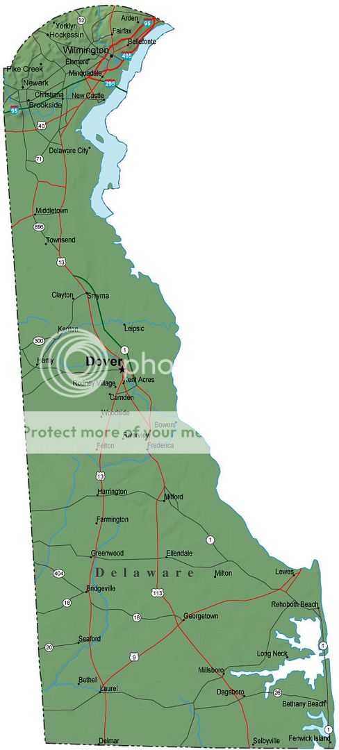
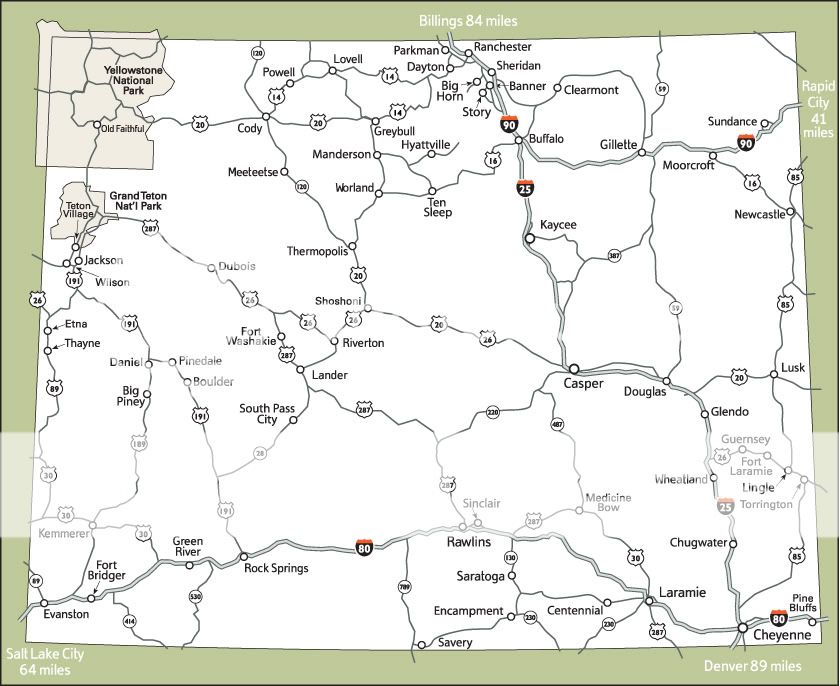
Here is another map of the state of Delaware, showing roads, counties, and cities.
Good map of the state of Delaware for free.


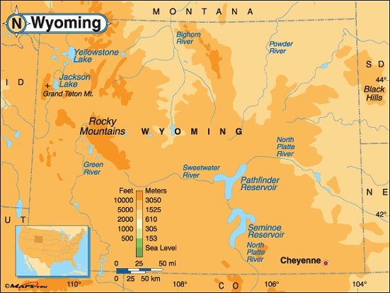
Here is a physical map of Delaware showing topography.
Free simple physical map of Delaware.


Were you able to find a good map of the state Delaware up above? Thanks for having a look at these maps. Be sure to bookmark or subscribe to the feed so you can check out more printable map collections in the future. See you next time!

Thursday, November 20, 2008

Map of the Week-Cotton Pickin' Democrats!

Yes these images have made the rounds of many other map blogs and yes I was supposedly done with Election 2008 but this is interesting. In my November 5th post I alluded to the county patterns and the possible race factor among others. Now we have courtesy of Allen Gathman from Southeast Missouri State University (Go Redhawks!) an explanation. He compared an 1860 map of cotton production to the pattern of southern counties that voted for Obama on this page. The Strangemaps blog took this a step further and actually overlaid the two maps. Each dot from the 1860 map represents 2000 bales of cotton.


There is the obvious racial component as the cotton belt counties have a higher concentration of African Americans. However, the Vigorous North blog takes this even another step beyond to show how the shallow ocean waters of the Cretaceous Period influenced the soil types and thus the suitability for cotton and thus the racial settlement patterns and thus the election results in the cotton belt counties.

The Map Of Minnesota State

Minnesota is a state in the Midwestern area of the United States of America. It is the northermost state in the continental US (ie. excluding Alaska which is further north of course), lying on the shores of Lake Superior and bordering Canada to the north. It is bordered to the west by North Dakota and South Dakota, Iowa to the south, Wisconsin to the east, and also shares a water border with Michigan.

It is the twefth largest US state by size, having a total area of 87,014 square miles
(225,365 km²). It is the 21st most populous state, with a population of 5,197,621. Almost 60% of those people live in the Minneapolis-Saint Paul metropolitan area (aka The Twin Cities).

Below you can find various versions of the map of Minnesota state.


This is one of the best road maps for Minnesota state that I've found.

Printable road maps for minnesota commuters.


Here's another small Minnesota highway maps for print.

Detailed Minnesota highway maps to print.


This is Superior National Forest Map Minnesota.


Superior National Forest map Minnesota.


This is the map of Minnesota state that I used to prepare for my business trip to a conference there.


Here is the map of Minnesota state for print or download.


I hope you found the maps of Minnesota above to be useful for reference and as a travel companion. Next time you go on a trip make sure to sure the map collections here! See you next time!

Wednesday, November 19, 2008

Printable State Of Ohio Map

If you are looking for a printable state of Ohio map, you've come to the right place! Ohio is a state in the Midwestern region of the United States of America. "Ohio" also means "Good morning" Japanese (as if you care!).

It is the 34th largest state in the USA, with a total area of 44,825 square miles
(116,096 km²). It borders Michigan to the north, Indiana to the west, Kentucky to the south, West Virgina to the southeast, and Pennsylvania to the northeast.

It is the 7th most populous state in the USA, with an estimated population of 11,466,917. Its largest city and captial is Columbus, with a population of 747,755 and a metropolitan area of 1,754,337. The metropolitan areas of Cincinatti and Cleveland are actually larger, despite the cities themselves having smaller populations than Columbus. Greater Cincinatti has a population of 2,133,678, BUT the urban is located not only in Ohio but also stretches across the borders into Indiana and Kentucky. The largest metropolitan area located completely in Ohio is Greater Cleveland with a population of 2,096,471.

Note that some of these map files are larger than they appear once you download them (I squeezed them into the small space here but the source file is full size).


Here is a good map of Ohio cities and towns.

Free detailed map of Ohio cities and towns.


Here is a detailed map of Ohio with roads and highways.Large detailed map of Ohio state for with roads and highways.


Here is a simple and printable state of Ohio map to download.

Simple printable state of Ohio map file.


Here is another Ohio map including counties and the capital city.
Ohio map including counties and their borders.


I hope you found the above printable state of Ohio map images useful. Make sure to print them and bring them along on your visit to Ohio. Don't forget to bookmark or subscribe before you go. Have a great trip!

Tuesday, November 18, 2008

Online Maps North Dakota

North Dakota is a state in the Midwestern United States. It is bordered to the south by South Dakota, to the west by Montana, to the east by Minnesota, and to the north by the Canadian provinces of Saskatchewan and Manitoba.

It is the 48th most populous state, with a small population of only 640,000. But it is the 19th largest state by size, with an area of 70,762 square miles (183,272 km²).

The largest city in North Dakota is Fargo, with a population of around 100,000, and a metropolitan population of 192,417. The capital is Bismarck, with a population of 55,532.

Here you can find some online maps North Dakota for free download or printout.

First is a North Dakota County map.

Free North Dakota Country Map downloads.


Next is a Geographical map North Dakota.Geographical Map North Dakota.


Here is a North Dakota road map.
Online Maps North Dakota.


I hope the above North Dakota county map and geographical map North Dakota printables were useful. Don't forget to check out our other map collections before you go! And for future reference be sure to subscribe or bookmark. See you next time!

Thursday, November 13, 2008

Map of the Week-Strolling Baby Through Weird Alternate Realities


Here's a delightfully odd marketing strategy. Bugaboo strollers (right) has enlisted some avant-garde artists to make a series of day trip maps for cities in Europe, North America and Australia. They have points of interest you can click on to get more info. Apparently "third world" places such as Asia, Africa and Philadelphia don't rate with them.

One of the more interesting ones is Mina Monnee's Portland. I especially like how she wrapped the river around it.


I also like Prague by Dustin Arnold.

Robert Nakata has some of the most "artistic". Here are his renderings of Toronto and Brighton (England)

State Of Arkansas Map

Arkansas is a state in the southern USA. It is bordered by Louisiana to the south, Texas to the southwest, Oklahoma to the west, Missouri to the north, and Tennessee and Mississippi to the east.

The population of Arkansas is 2,834,797, making it the 32nd most populous US state. The capital and largest city is Little Rock, with a population of 187,452, and a metropolitan population of 666,401.

The total area of the state is 116.8 square miles (302.5 km²). The Arkansas River runs through the state, and Little Rock is located on the edge of the river.

Here is a detailed map of Arkansas. This is the thumbnail, but you can see the full map by clicking the thumbnail.

Thumbnail of detailed map of Arkansas.

Here is another few state of Arkansas map files to print or download. I hope you found them useful.State map of Arkansas counties.


Printable state of Arkansas map for travelers.


State of Arkansas map for visitors to the USA.


The state of Arkansas is a lovely place to visit, and I hope the above maps were helpful in planning your trip. Enjoy your stay in Arkansas!

Tuesday, November 11, 2008

Map Of Cities Counties In Oklahoma

Oklahoma is state in the southcentral area of the United States of America. It has a population of 3,617,316, making it the 28th most populous state. The largest city and capital is Oklahoma City, with 537,734 residents. The metroplitan area has approximately 1,192,989.

Oklahoma's total land area is 69,898 square miles (181,196 km²), making it the 20th largest state. Oklahoma is located north of Texas, west of Arkansas, south of Kansas, southwest of Missouri, and southeast of Colorado.

Below you will find a map of cities counties in Oklahoma state. Please download as print these out as you wish.


Grey map of cities counties in Oklahoma for travelers.


Road map of cities counties in Oklahoma.


Multicolored map of cities counties in Oklahoma state for out of state travelers.


Black and white map of cities and counties in Oklahoma for visiting tourists to print and carry.


I hope you found useful state map of cities and counties in Oklahoma. Be sure to subscribe or bookmark before you go.

Monday, November 10, 2008

Printable Map Of Wyoming

Wyoming is a state in the Western United States, which lies in the area of the Rocky Mountains, with the eastern section of the state lying in the High Plains area. It is the least populous state in the union, with only 522,830 people. It is, however, the tenth largest state by size. Its total land area is 97,818 square miles(253,348 km²).

The capital and largest city in Wyoming is Cheyenne, with a populous of 53,011. Don't feel bad if you've never heard of it. Most people haven't.

Wyoming lies south of Montana, west of South Dakota and Nebraska, north of Colorado, northeast of Utah, and east of Idaho.

For those of you planning on trekking out into this sparsely populated area, here you can find a printable map of Wyoming for reference during your travels.


Printable Maps Of Wyoming for travelers.


Wyoming map printable for reference.


Physical printable Maps of Wyoming for visitors.


Printable map of Wyoming state and its regions and counties.


It's my hope that you found a printable map of Wyoming up above that was helpful to you. Be sure to check out some other map themes and destination profiles before you go. See you later!

State Of New Mexico Map

The US state of New Mexico is located in the southwestern United States, east of Arizona, west of Texas, south of Colorado. And its corner touches Utah at the Four Corners monument at the point where New Mexico, Colorado, Arizona, and Utah meet. It was formerly a Spanish colony, then part of Mexico, and then a territory of the US before becoming a US state.

The population of New Mexico is 1,969,915, making it the 36th most populous state. More than 28% of the population speak Spanish as their first language at home. The state also has a large Native American population, with 4.07% speaking Navajo at home.

The total area of New Mexico is 121,665 square miles (315,194 km²), making it the 5th largest state in the USA.

Below you can find a State of New Mexico map for additional information and reference.

This first printable map of New Mexico is shown smaller on the screen here than it will appear after download.
State of New Mexico Map Printable download.


Printable State Of New Mexico Map.


Printable Map of New Mexico state.


Printable state of New Mexico map for travelers.


Thank you for visiting Free Printable Maps. I hope you founf a state of New Mexico that was useful for you. Be sure to check back for more map collections soon.

Sunday, November 9, 2008

Entire Map Of Texas

Texas is a state located in the southern United States. Nicknamed the "Lone Star State", it is the second largest and second most populous US state. It has a total land area of 268,820 square miles (696,241 km²), and a population of 23,904,380 (it is second to California). Though Texas is the second most populous state, it is also large so its population density isn't very high. By population density it is ranked #26 in the US.

The capital city of Texas is Austin (population 743,074), but the largest city is Houston (population 2,208,180, metro population 5,628,101), and the largest metro area is Dallas-Fort Worth-Arlington (population 6.1 million). The city of Dallas by itself has 1,232,940 people, making it third most populous.

This is a large Texas map, so I've posted the thumbnail. Click on the thumbnail to see the full size map.


The entire map of Texas is quite large and detailed, so it may take a lot of examining to find the information you're looking for. But thank you for checking out these large Texas maps. I hope you check out more of my map collections before you leave. See you again!

Saturday, November 8, 2008

Texas Airports Map

Texas is of course a highly populous state so it has a great number of airports. Here I've tried to include maps that include the most commonly used airports and how to access them. The first map is a Texas airports map for the whole state showing major commercial airports, and the others are city airports for Austin, Houston, and Dallas.


Texas Airports Map for the whole state.


Texas airports map for the city of Houston.


Dallas Texas airports map for your reference.


Austin Texas airports map for print out and travel.


I hope you were able to find a Texas airports map that was helpful. Good luck on all your travels, and I hope you have a safe journey into or out of the state of Texas.

Map Kansas Cities

Kansas is a state in the Midwest of the United States, basically in the center of the country. It has a population of 2,775,997, making it the 33rd most populous state in the union. The largest city is Wichita, with a population of 357,698. The second most populous, which are both found in the Kansas City metropolitan area, are Overland Park, with 166,722 people, and Kansas City with 143,801. Note that while Kansas City, Kansas is located near Kansas City Missouri, they are not the same city and their populations are counted separately. Both are named after the Kansas River, which flows through both states.

Here you can find a map. Kansas cities and towns appear in these maps, as well as counties.

Map Kansas Cities and towns for print.


Map of Kansas cities towns and counties.


Was the map Kansas cities and towns useful to you? I hope it was useful. Please make sure to see my other map collections and place descriptions. And be sure to subscribe or bookmark before you go!

Map Of Arizona Cities

Arizona is a state located in the southwestern United States, bordering Mexico to the south. It also borders California to the west, Nevada to the northwest, Utah to the north, New Mexico to the east, and touches Colorado at the corner point where Nevada, New Mexico, Colorado, and Utah touch each other. The "Four Corners" monument lies at that point where the 4 states meet.

Arizona was the last of the contiguous states that was admitted to the union, on February 14th, 1912.

It is the 16th most populous state with a population of 6,338,755. The capital and largest city is Pheonix, with 1,552,259 residents, making it the 5th largest city in the USA. The metropolitan area has a population of 4,579,427, the thirteenth largest in the country.

Below you can find a map of Arizona cities for your reference.


Map of Arizona cities for free download.


Free cities map Arizona Pheonix and others.


Map cities Arizona state towns and four corners.


Map Of Arizona cities printable for reference and travel.


I hope you located cities map Arizona printables for your travels. Please to check out some other map collection before you go. See you again!