Saturday, December 31, 2011

San Antonio Map

San Antonio is another one of those places that to me always seemed like it only existed on tv and in the movies. I associate it with spicy food and cowboy films. But it is actually a massive city, the seventh largest city in the United States and bigger than Dallas. It has a population of 1.3 million people, with the metropolitan region having about 2.2 million. Even though the city itself is seventh largest in the US, the metro area is not nearly seventh biggest, in fact it is only the 24th largest metro area, which can make San Antonio seem comparatively small, relative to other cities of a similar population.

San Antonio lies at on the Western border of the humid subtropical region, and can be either very humid or dry depending on various factors. It is very hot in the summer, with cool to warm winters. Winters can see fairly high daily high temperatures, but at night the temperature occasionally falls below zero. Snow falls about once every four years in San Antonio. March through November sees daily high temperatures above 20 degrees celsius.


This first San Antonio map shows the major roads and highways of the city.


This is a simple map of Greater San Antonion, Texas.

Greater San Antonio map with suburbs

This is an interstate map of San Antonio.

San Antonio map for visitors

Friday, December 30, 2011

San Diego Map

San Diego is often overshadowed by Los Angeles which is found just a couple of hours to its north. Los Angeles is the second largest city in the US, and the largest in the Western US, not to mention it is a center of the entertainment industry and looms large in everyone`s imaginations. But don`t be fooled - San Diego is no small town, and has plenty of beauty and excitement to offer.

San Diego is actually the eighth largest city in the United States and has a population of around 1.3 million. The metro area has around 3.1 million, making this a bonafide metropolis. It was once a part of Mexico, until it was lost to the United States in war and became part of the union (along with all of California) in 1850. It lies immediately next to the Mexican border, with Tijuana essentially forming part of the San Diego metro area, despite the border in between.

It is a beautifully scenic place with gorgeous beaches and palm trees lining the streets, with mild to warm weather year round. It is one of the most pleasant places to live in the U.S.

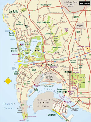
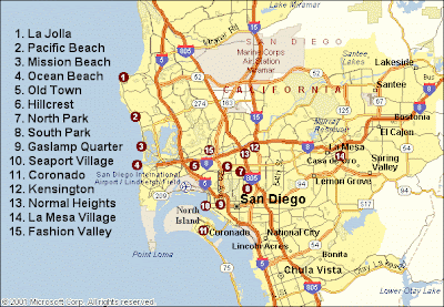
Here is a basic San Diego map showing the central area and major roads.

San Diego Map

Here`s a map of San Diego showing the city in more detail.

map of San Diego

This is a San Diego map with major landmarks indicated.

San Diego map with landmarks

Phoenix Map

When you think of Phoenix, Arizona you may think of a small dusty town in the middle of the desert, full of cactii and palm trees. Well, all of those things are kind of true except for the "small" part. Phoenix is a big city, so big that visitors are often surprised. It is the sixth largest city in the United States, with a population of close to 1.5 million (and that`s in the city alone, not the metropolitan area). The metro area has around 4.2 million, making this a full-on metropolis.

Phoenix is one of the hottest cities in the United States, which rivals some of the hottest places in the Middle East during the summer months. In an average year, 110 days will see temperatures of over 38 degrees celsius (100 degrees F). From May until September, temperatures are HOT by anyone`s definition. The highest temperature to ever hit the Arizona city was 50 degrees (122 degrees F). In the winter Phoenix is not hot, and night and morning temperatures can occasionally reach below freezing and frost is a common occurrence (though not as much in central Phoenix where the city heat brings the temperature up a little bit). Rainfall is scarce, though summer monsoon weather raises humidity with occasional heavy rain.


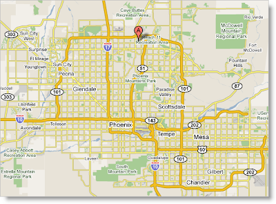
This first Phoenix map is a simple one showing the streets and highways of the central area.

Arizona Phoenix map

This next one is a great Phoenix tourist map. To make this bigger just click on the photo.

Phoenix Map

Here is a map of the Phoenix area

Map of Phoenix area

Here`s another great Phoenix map for tourists.

Map of Phoenix AZ

Thursday, December 29, 2011

Map of Philadelphia

Philadelphia is one of those cities you may have never been to, but have definitely heard of from music, movies, and tv. It is a culturally important place, but not in the same way that some other major cities in the US are. That is partly because of Philadelphia`s proximity to New York City, by which it is often overshadowed.

The city has a population of over 1.5 million, and is the focal point of the Delaware Valley, a metro area with a total of over 6 million people. Philly is fifth largest city in America, and the metro area is also the fifth largest in the country. But the whole of the Northeastern United States is so densely populated that is almost like one giant megalopolis, incorporating both New York City whose metro area spreads over into Connecticut and New Jersey; Philadelphia whose metro area spreads from Pennsylvania into Delaware and New Jersey; Boston whose metro area spreads from Massachusetts into New Hampshire; Pittsburgh which is in Pennsylvania; Providence which spreads from Rhode Island into Massachusetts; Hartford in Connecticut; and Buffalo and Rochester in New York.

This first map of Philadelphia shows the city and its surrounding areas.

Map of Philadelphia and outlying areas

This next Philadelphia map shows the downtown area and its streets.

Map of Philadelphia streets

This last Philadelphia map is a good one for tourists, because it indicates important landmarks.

Tourist map of Philadelphia

Wednesday, December 28, 2011

Map of Houston Texas

When you think of Texas, you might think of dry desert land and tumbleweeds blowing in the wind, cowboys riding on horses, and people firing rifles. But Texas is a lot more than just wild frontier, which becomes evident when you visit the huge major city of Houston. Houston is the fourth largest city in the United States, after New York City, Los Angeles, and Chicago. With a population of 2.1 million it is hardly the rural frontier you may have been picturing a moment ago. The Houson-Sugar Land-Baytown metropolitan area is the sixth largest in America with around 6 million people.

Houston is located bnear the Gulf of Mexico and has a humid subtropical climate. On average, over 99 days per year see temperatures above 32 degrees celsius (90 degrees F), which may not sound blistering hot but remember the humidity can reach over 90 percent relative humidity. The hottest temperature on record in Houston was 43 degrees celsius (109 degrees F). That is far from the hottest temperature recorded in the US, but Houston`s consistent year round relative heat is what it is known for. In winter, the high temperatures hover around 17 degrees celsius, with cold nights reaching as low as 4 degrees celsius. So Houston isn`t always hot, but is hotter than most places.

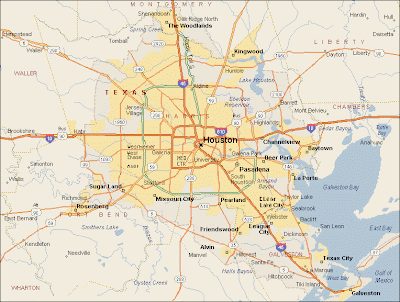
Here you can find a map of Houston Texas for your information and reference.

Road map of Houston Texas
Houston map

This Houston map shows the central part of the city without all the outlying areas.

Map of Houston central area

The Frosted States of America

My wife is obsessed with cookie cutters. We travel places and get them as souvenirs. A few years ago I decorated a cookie as a Vermont Foliage Map. Our friend's son Ezra just one upped me with this rendering of the entire lower 48 on a remarkably small US shaped cookie.


He even followed the rule about no same colored states touching-except for a last minute blunder at Vermont. You can nitpick about other geographical details but I doubt you can do better. Nice job Ezra!

Monday, December 26, 2011

Chicago Neighbourhood Map

Chicago is a huge city that may seem daunting to navigate, but it can easily broken down into districts and neighbourhoods. If you think of the city not as a single monolithic whole but rather as a collection of smaller areas, it is much easier to take in the city. The city as a whole has a population of about 2.7 million. The entire metro area has 9,461,105, but that includes towns outside of Chicago proper, and therefore separate from the neighbourhoods in the maps below.

There are around 200 unofficial neighbourhoods in Chicago, and 77 official "community areas" which are used for administrative and planning purposes.

Here you can see a Chicago neighbourhood map for reference.Chicago Neighbourhood map in full detail
Chicago neighbourhood map showing major districts

Saturday, December 24, 2011

Chicago Transmit Map

CTA, or Chicago Transit Authority is the mass transit system covering the massive city of Chicago and its surrounding metro area. This is one of the easiest and most convenient ways to get around the Windy City, since transit reaches pretty much every area of the city, bypassing all the horrendous traffic that can sometimes pile up. The transit system includes the former Chicago Surface Lines, which is an above-ground street car network that became part of the CTA. A train system is also part of the Chicago Transit Authority.

Here is a useful Chicago Transit Map showing the CTA system.

Chicago Transit Map

Friday, December 23, 2011

Chicago Map

Chicago is the principal city in the state of Illinois, and is the third biggest city in the United States in terms of population (number 1 is New York City and number 2 is Los Angeles). The city itself has about 2.7 million people, while the metro area of "Chicagoland" has about 9.8 million. O`hare International Airport that serves Chicago is the second busiest airport in the world, when including both passenger traffic and cargo traffic. Chicago is a big center for business, finance, and industry which accounts for a large part of that traffic.

Chicago is situated on the edge of Lake Michigan, and two rivers flow through the city: the Chicago River which flows through downtown, as well as the Calumet River which flows through the industrial area of South Chicago. The city is nicknamed "The Windy City" because of the breezes that blow from these bodies of water. I`ve only spent a day or so in Chicago, but the wind was bone-chilling.

For such a huge city, it was founded surprisingly recently, in 1833. It was one of the fastest growing cities in history.

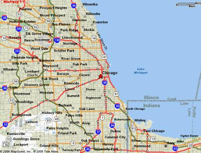
Below you can find a Chicago map showing the central city area and the roads leading to and from it.


Chicago map showing roads
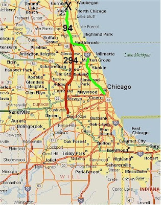
Chicago map with highways
Simple downtown Chicago map

Were you able to find a downtown Chicago map that was useful? Be sure to check out other maps of Chicago in the USA City Maps category.

Thursday, December 22, 2011

The "Greatest Grid"

Yesterday I made a trip to the Museum of the City of New York to see The Greatest Grid. This exhibit celebrates the 200th anniversary of the Commissioner's Plan of 1811 that established the city's grid system. The exhibit is full of historic maps and the centerpiece is the Commissioners Plan Map of 1811 laid out on a glass covered table.


The grid was placed over the more sparsely settled areas above North Street (now Houston) without regard to the city's topography, water features or existing houses. Villages such as Harlem were eliminated to make room for straight streets. Houses that stood in the way (or even near the way) were demolished or moved. There is a section of the exhibit showing how houses were moved to accommodate the grid. This map from the exhibit's web site is one of many that show the land before the streets were built with the grid superimposed in light gray.


The exhibit starts with a video loop of residents proudly stating their address along the grid eg."125th and First!" After spending hours gawking at the maps you can go upstairs and see The Unfinished Grid, a collection of future design speculations resulting from a call for ideas from the Architectural League of New York. Many of these designs revolve around ways to break free from the grid's restrictions.

This collection of maps, photographs, newspaper clippings and other artifacts is very impressive and well worth a visit if you are in the New York metropolitan area. It runs through April 15th, 2012. The museum is located on the grid, at 5th and 103rd.

Map of New York City

New York City is widely considered "The Capital of the World". It is the center of one of the most populous metro areas in the world, and the city itself is the largest in the United States. It is also the center of world commerce and finance, culture such as fashion and art, and an important center for education, research and other aspects of global life. New York City is a name that evokes grand imagery in the minds of people everywhere. Even people who have never been to New York have an image of the city from movies, tv, and music.

NYC has a population of 8,175,133, with the metro area having close to 19 million people. The city is divided into 5 boroughs, each of which has its own personality and local consciousness, and each of which (strangely) is administered by a different county. The boroughs are Manhattan, The Bronx, Brooklyn, Queens, and Staten Island.

Newark, New Jersey is just across the water from downtown Manhattan and is a part of Metro NYC, except it is not in New York state but rather in New Jersey.

Here is a great detailed map of New York City showing all of the major roads and boroughs of the city.

Map of New York City Area

These next couple of maps show a little less detail but are still useful for navigating this mammoth city.

Map of New York City
Road map of New York City

Wednesday, December 21, 2011

Blank Map of North America

North America is the continent located in the Northern Hemisphere, and for the most part located in the Western Hemisphere. Some people think of North America as only Canada and the United States, but it also includes Mexico, the countries of Central America, and the Caribbean including Cuba, and some people include Greenland as part of North America even though it is a territory of Denmark. Though there are many common definitions of North America that include any combination of the above.

If we include all of the above, the population of North America is around 528,720,588, and it has a total land area of 24,709,000 square km (that means 9,540,000 square miles for you Americans). The most commonly spoken languages in North America are English and Spanish, but French is also spoken in some places including the Canadian province of Quebec and is an official language of Canada.

The first blank map of North America and the second show the state and provincial boundaries, but the names of those provinces and states are not indicated.

Blank map of North America with state and provincial borders indicated
Blank map of North America with State and provincial borders

The next two blank North America maps have no state or provincial borders. These are obviously more challenging to fill in.

North America blank map with no state borders
Blank map of North America without regional borders

Tuesday, December 20, 2011

Blank Map of Middle East

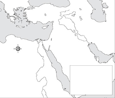
Here you can find a blank map of the Middle East for your reference and self study. In some of the maps the country borders are indicated, but the names of the countries and their cities and other features are not indicated.

Maps of the Middle East are not static, and sometimes political changes occur in the Middle East, due to wars and so on. On top of that, some countries or geographic features are referred to by different names depending on who is speaking. For example, Israel is not recognized as a country by many Arabs so Israel is often replaced with "Palestine" on maps produced in Arab countries. And the Persian Gulf, as most Westerners know it, is referred to as "The Arabian Gulf" by Arabs. Keep these kinds of things in mind when deciding how to label your blank maps.

This first map does not include country borders. Ironically, that may actually make your life simpler when it comes time to label the map!

Blank map of the Middle East

It could be said that this map is outdated, because it shows the Westbank (currently occupied by Israel and under partial Palestinian autonomy) as part of Jordan. This hasn`t been the reality since 1967. It also shows the Gaza Strip as part of Egypt.

Blank map of Middle East

The next blank map of the Middle East is not out of date, but you can say its borders related to Israel and Palestine are incomplete. The Westbank and the Gaza Strip are not indicated. In an Arab country, the entire country would be labelled "Palestine" and in Israel, the entire country would be labelled "Israel". In Israel it is actually illegal to produce a commercial map that indicates the boundaries of the Westbank and Gaza.

Small blank map of the Middle East with borders indicated

Blank Map of Central America

Contrary to popular belief, Central America is neither a continent in and of itself, nor a part of South America. It is geographically a part of North America, though is typically thought of as its own sub-region because of the cultural, political, and economic ties between the countries in the area.

Central America includes Panama, Belize, El Salvador, Costa Rica, Guatemala, Honduras, and Nicaragua. Some people tend to include Mexico because of its linguistic and cultural ties to the sub-region, but really it is not part of Central America. The official language of every country is Spanish, yet numerous indigenous languages are also spoken. Around 42 million people live in these countries, across an area of 523,780 square km.

This first blank map of Central America includes and insert with the Caribbean region.

Blank Map of Central American and Caribbean
Blank map of Central America

This blank Central America map also shows the adjacent areas in North America and South America.

Blank map of Central America and surroundings

Monday, December 19, 2011

Blank Map of Asia

Asian geography is not typically covered in United States high school curriculum, as far as I know. At least not in great detail. But I do get a lot of emails from people in Canada and Australia and other places who request more maps of Asia. Some of them are studying about Asia in school, and need some study aids like a blank map of Asia. So I decided to upload a small collection of such maps for those people to make use of.

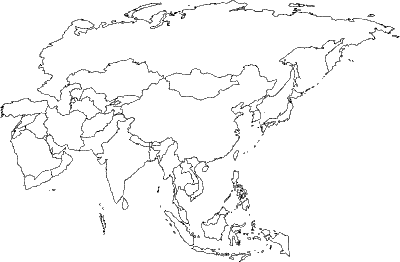
Asia is a huge continent with a lot of countries in it, so you probably can`t just memorize the map of Asia passively. So these blank Asia maps will help you when you practice and quiz yourself, then when time finally comes for your big geography test you will be confident about where all the countries are.

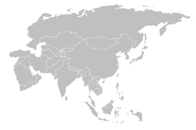
Blank map of Asia with borders indicated
Gray blank Asia map

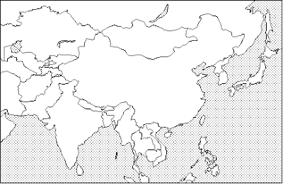
This map doesn`t quite show all of Asia, it just shows parts of Western Asia (though other parts are cut off) and South Asia (including India and Pakistan), Central Asia and East Asia. Some people don`t think of the Middle East or Western Asia when they say the word "Asia", so maybe this map is all you want. But in the two maps above, all of Asia is included, including the Middle East, etc.

Blank map of South and East Asia

Sunday, December 18, 2011

Political Map of Africa

Africa is the huge continent situated to the south of Europe. It is the second largest continent in the world, and has the second biggest population out of any continent in the world. Approximately 14.72% of the world`s population is in Africa. In specific numerical terms, that means around one billion people, similar to the population of India or China.

Africa is usually said to have 55 countries, which includes the disputed territory of Western Sahara (which is internationally recognized but is occupied by Morrocco). 48 of these countries are located on the mainland of the African contient, while 6 are island nations. It also includes the very new country of Southern Sudan.

The African Union includes 54 of the 55 internationally recognized African countries, with Morocco refusing to join because of the AU`s inclusion of Western Sahara.

There are other de facto nations with their own independently operating governments in Africa, specifically in the place we commonly know as Somalia. Only one government is internationally recognized in Somalia, but 2 de facto nations of Somaliland and Puntland exist in different areas of the country. The only thing that keeps Somaliland and Puntland from being on the political map of Africa is a lack of recognition by other countries. In practical terms, they are independent. This was the situation with South Sudan until its recent independence.


Here are some political Africa maps for your reference.

White political map of Africa
Africa Political map from Atlas

Update: Here is a 2012 political map of Africa that includes the world`s newest country: Southern Sudan.

2012 Political map of Africa with Southern Sudan

Saturday, December 17, 2011

Political Map of Asia

Asia is the largest of the world`s continents, and also the one with the biggest population. 60% of the world`s population lives in Asia. It is technically not a continent in geographic terms, but rather a subcontinent of Eurasia. But in political terms it is its own continent, as it is by convention.

Asia is a massive and culturally diverse continent. There is little in common between Jakarta and Tokyo and Riyadh, but all of them are in Asia. More conveninent regional categories exist, such as "Southeast Asia" or "Middle East" or Northeast Asia, which tend to represent more logical cultural groupings and economic partnerships.

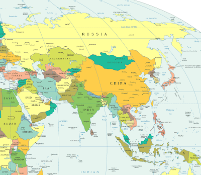
Below you can check out a political map of Asia for your reference.

Basic political map of Asia
Nearly blank political map of Asia
Atlas political map of Asia

I hope the Asia political maps above were useful!

Friday, December 16, 2011

Blank Map of the United States

A while ago I posted an entry about printable maps of the USA, and one of the most popular maps on that page was a blank map of the United States. So today I decided to gather more maps similar to that one and upload them for your benefit.

People who might benefit from these blank USA maps are students who are studying American geography in school and need to quiz themselves, and also teachers who can use these maps for geography tests and the like. I always had a hard time memorizing the locations of all 50 states, so I wish I could have easily printed out maps like this when I was in highschool. Maybe I would have gotten a better grade in geography!

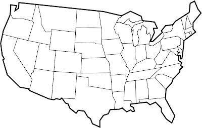
Below you can choose a blank map of the United States to print out.

Blank map of the United States
Blank map of the continental United States
Gray and blank map of the United States
Blank USA map with thick black borders